
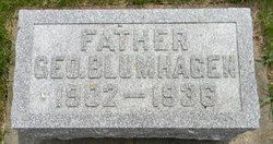

George Blumhagen
| Birth | : | 8 Aug 1902 Winneshiek County, Iowa, USA |
| Death | : | 3 Feb 1936 Decorah, Winneshiek County, Iowa, USA |
| Burial | : | Wilbury Hills Cemetery, Letchworth, North Hertfordshire District, England |
| Coordinate | : | 51.9862210, -0.2474770 |
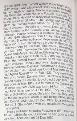
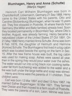
| Description | : | He married Mabel Meyer on 19 Feb 1931 and they were the parents of Mardella, Loren, and Loretta. After his death, Mable married Carl Schnitzler. Postville Herald, Thursday, February 6, 1936 Geo. Blumhagen Passes At a Decorah Hospital (Castalia Correspondent) Funeral services will be held here Thursday afternoon at 1:30 from the Zion Lutheran church for Geo. Blumhagen, a young farmer residing about 1-1/2 miles northeast of Castalia, the Rev. Wm. Striepe officiating. George Blumhagen, son of Mr. and Mrs. Henry Blumhagen, was born on a farm near Castalia, August 8, 1902, and passed away at the Decorah hospital , Monday, February 3, 1936, following... Read More |
frequently asked questions (FAQ):
-
Where is George Blumhagen's memorial?
George Blumhagen's memorial is located at: Wilbury Hills Cemetery, Letchworth, North Hertfordshire District, England.
-
When did George Blumhagen death?
George Blumhagen death on 3 Feb 1936 in Decorah, Winneshiek County, Iowa, USA
-
Where are the coordinates of the George Blumhagen's memorial?
Latitude: 51.9862210
Longitude: -0.2474770
Family Members:
Parent
Spouse
Siblings

Children
Flowers:


Nearby Cemetories:
1. Wilbury Hills Cemetery
Letchworth, North Hertfordshire District, England
Coordinate: 51.9862210, -0.2474770
2. Icknield Way Cemetery
Letchworth, North Hertfordshire District, England
Coordinate: 51.9787300, -0.2506100
3. Fairfield Hospital Cemetery
Stotfold, Central Bedfordshire Unitary Authority, England
Coordinate: 52.0040420, -0.2495440
4. St Nicholas Churchyard
Letchworth, North Hertfordshire District, England
Coordinate: 51.9948300, -0.2078900
5. North Hertfordshire Memorial Park and Crematorium
Holwell, North Hertfordshire District, England
Coordinate: 51.9847244, -0.2967870
6. All Saints Churchyard
Willian, North Hertfordshire District, England
Coordinate: 51.9609140, -0.2191160
7. Baldock Cemetery
Baldock, North Hertfordshire District, England
Coordinate: 51.9901010, -0.1960690
8. St Mary the Virgin Churchyard
Stotfold, Central Bedfordshire Unitary Authority, England
Coordinate: 52.0150980, -0.2232980
9. St Mary Churchyard
Baldock, North Hertfordshire District, England
Coordinate: 51.9897380, -0.1898930
10. Stotfold Cemetery
Stotfold, Central Bedfordshire Unitary Authority, England
Coordinate: 52.0186450, -0.2189540
11. St. Peter's Churchyard
Arlesey, Central Bedfordshire Unitary Authority, England
Coordinate: 52.0234710, -0.2643140
12. Hitchin Cemetery
Hitchin, North Hertfordshire District, England
Coordinate: 51.9429090, -0.2732690
13. All Saints Churchyard
Radwell, North Hertfordshire District, England
Coordinate: 51.9747300, -0.1668550
14. St. Vincent Churchyard
Newnham, North Hertfordshire District, England
Coordinate: 52.0229100, -0.1897200
15. All Saints Churchyard
Upper Stondon, Central Bedfordshire Unitary Authority, England
Coordinate: 52.0065450, -0.3258350
16. St Mary Magdalene's Church
Caldecote, North Hertfordshire District, England
Coordinate: 52.0304700, -0.1989020
17. St Mary Churchyard
Henlow, Central Bedfordshire Unitary Authority, England
Coordinate: 52.0348580, -0.2834610
18. Saint Mary the Virgin Churchyard
Pirton, North Hertfordshire District, England
Coordinate: 51.9722000, -0.3316600
19. St Ippolyts Church
St Ippolyts, North Hertfordshire District, England
Coordinate: 51.9298460, -0.2591680
20. Clifton Friends Burial Ground
Clifton, Central Bedfordshire Unitary Authority, England
Coordinate: 52.0378800, -0.3033100
21. All Saints Churchyard
Clifton, Central Bedfordshire Unitary Authority, England
Coordinate: 52.0393990, -0.3015550
22. Clifton Baptist Chapelyard
Clifton, Central Bedfordshire Unitary Authority, England
Coordinate: 52.0398940, -0.3025180
23. All Saints New Churchyard
Clifton, Central Bedfordshire Unitary Authority, England
Coordinate: 52.0403500, -0.3018700
24. St Mary the Virgin Churchyard
Meppershall, Central Bedfordshire Unitary Authority, England
Coordinate: 52.0102000, -0.3483000