
| Memorials | : | 0 |
| Location | : | Clifton, Central Bedfordshire Unitary Authority, England |
| Coordinate | : | 52.0393990, -0.3015550 |
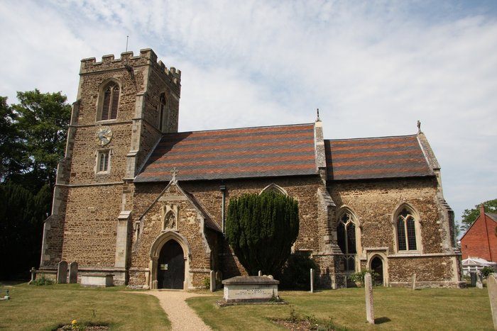
| Description | : | All Saints Church, built in the 14th and 15th centuries was heavily restored in the 19th. Nearby is the New Churchyard on Stanford Lane. |
frequently asked questions (FAQ):
-
Where is All Saints Churchyard?
All Saints Churchyard is located at Church Street Clifton, Central Bedfordshire Unitary Authority ,Bedfordshire , SG17 5ELEngland.
-
All Saints Churchyard cemetery's updated grave count on graveviews.com?
0 memorials
-
Where are the coordinates of the All Saints Churchyard?
Latitude: 52.0393990
Longitude: -0.3015550
Nearby Cemetories:
1. Clifton Baptist Chapelyard
Clifton, Central Bedfordshire Unitary Authority, England
Coordinate: 52.0398940, -0.3025180
2. All Saints New Churchyard
Clifton, Central Bedfordshire Unitary Authority, England
Coordinate: 52.0403500, -0.3018700
3. Clifton Friends Burial Ground
Clifton, Central Bedfordshire Unitary Authority, England
Coordinate: 52.0378800, -0.3033100
4. St Mary Churchyard
Henlow, Central Bedfordshire Unitary Authority, England
Coordinate: 52.0348580, -0.2834610
5. St Andrew Churchyard
Langford, Central Bedfordshire Unitary Authority, England
Coordinate: 52.0583270, -0.2721350
6. St. Peter's Churchyard
Arlesey, Central Bedfordshire Unitary Authority, England
Coordinate: 52.0234710, -0.2643140
7. Campton and Shefford Cemetery
Campton, Central Bedfordshire Unitary Authority, England
Coordinate: 52.0351600, -0.3483720
8. Langford Cemetery
Langford, Central Bedfordshire Unitary Authority, England
Coordinate: 52.0640000, -0.2710830
9. All Saints Churchyard
Southill, Central Bedfordshire Unitary Authority, England
Coordinate: 52.0666240, -0.3298690
10. All Saints Churchyard
Campton, Central Bedfordshire Unitary Authority, England
Coordinate: 52.0295430, -0.3544430
11. Chicksands Priory
Chicksands, Central Bedfordshire Unitary Authority, England
Coordinate: 52.0370000, -0.3600000
12. All Saints Churchyard
Upper Stondon, Central Bedfordshire Unitary Authority, England
Coordinate: 52.0065450, -0.3258350
13. St Mary the Virgin Churchyard
Meppershall, Central Bedfordshire Unitary Authority, England
Coordinate: 52.0102000, -0.3483000
14. Fairfield Hospital Cemetery
Stotfold, Central Bedfordshire Unitary Authority, England
Coordinate: 52.0040420, -0.2495440
15. St George Churchyard
Edworth, Central Bedfordshire Unitary Authority, England
Coordinate: 52.0510350, -0.2189810
16. St. Leonard's Churchyard
Old Warden, Central Bedfordshire Unitary Authority, England
Coordinate: 52.0855860, -0.3424550
17. St Andrew Churchyard
Biggleswade, Central Bedfordshire Unitary Authority, England
Coordinate: 52.0875360, -0.2666970
18. St Mary the Virgin Churchyard
Stotfold, Central Bedfordshire Unitary Authority, England
Coordinate: 52.0150980, -0.2232980
19. North Hertfordshire Memorial Park and Crematorium
Holwell, North Hertfordshire District, England
Coordinate: 51.9847244, -0.2967870
20. Stotfold Cemetery
Stotfold, Central Bedfordshire Unitary Authority, England
Coordinate: 52.0186450, -0.2189540
21. Beadlow Priory
Clophill, Central Bedfordshire Unitary Authority, England
Coordinate: 52.0339100, -0.3905900
22. St Giles Churchyard
Gravenhurst, Central Bedfordshire Unitary Authority, England
Coordinate: 52.0112000, -0.3797000
23. Drove Road Cemetery
Biggleswade, Central Bedfordshire Unitary Authority, England
Coordinate: 52.0895000, -0.2527300
24. St Marys Churchyard
Gravenhurst, Central Bedfordshire Unitary Authority, England
Coordinate: 52.0045690, -0.3821720