
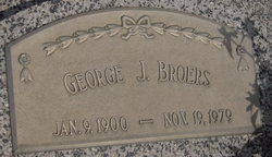
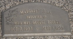
George J Broers
| Birth | : | 9 Jan 1900 Nebraska, USA |
| Death | : | 19 Nov 1979 Sterling, Johnson County, Nebraska, USA |
| Burial | : | St. Remigius Churchyard, Roydon, South Norfolk District, England |
| Coordinate | : | 52.3815610, 1.0784680 |
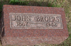
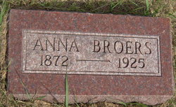
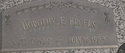
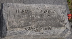
| Description | : | 1920 US Census: parents John J & Anna Broers - both born in Germany - all the children were born in Nebraska. Children listed - Herman J 23yrs; Margaret 22yrs; George J 19 yrs; Carl 18 yrs; Carrie 16 yrs; Frank 14yrs; Edwin 7 yrs; and Bertha 7yrs - showed them living in Helena, Johnson Co, NE. 1930 US Census shows George married to Dorothy and having Merlin 6yrs and living in South Branch Precinct, Otoe Co, NE |
frequently asked questions (FAQ):
-
Where is George J Broers's memorial?
George J Broers's memorial is located at: St. Remigius Churchyard, Roydon, South Norfolk District, England.
-
When did George J Broers death?
George J Broers death on 19 Nov 1979 in Sterling, Johnson County, Nebraska, USA
-
Where are the coordinates of the George J Broers's memorial?
Latitude: 52.3815610
Longitude: 1.0784680
Family Members:
Parent
Spouse
Siblings

Children
Flowers:


Nearby Cemetories:
1. St. Remigius Churchyard
Roydon, South Norfolk District, England
Coordinate: 52.3815610, 1.0784680
2. Croft Lane Baptist Church Burial Ground
Diss, South Norfolk District, England
Coordinate: 52.3771070, 1.1025490
3. St. John the Baptist Churchyard
Bressingham, South Norfolk District, England
Coordinate: 52.3853850, 1.0489290
4. Bressingham Cemetery
Bressingham, South Norfolk District, England
Coordinate: 52.3854520, 1.0486290
5. Diss War Memorial
Diss, South Norfolk District, England
Coordinate: 52.3773380, 1.1088530
6. Saint Mary Churchyard
Diss, South Norfolk District, England
Coordinate: 52.3772370, 1.1097880
7. Diss Cemetery
Diss, South Norfolk District, England
Coordinate: 52.3839060, 1.1115880
8. Unitarian Chapel Cemetery
Palgrave, Mid Suffolk District, England
Coordinate: 52.3693130, 1.1086820
9. St Peter Churchyard
Palgrave, Mid Suffolk District, England
Coordinate: 52.3634190, 1.1059170
10. All Saints Churchyard
Shelfanger, South Norfolk District, England
Coordinate: 52.4104780, 1.0969230
11. St Andrew Churchyard
Fersfield, South Norfolk District, England
Coordinate: 52.4043450, 1.0351310
12. St Andrew's Frenze Church
Scole, South Norfolk District, England
Coordinate: 52.3802000, 1.1361000
13. St. Mary the Virgin Churchyard
Redgrave, Mid Suffolk District, England
Coordinate: 52.3632900, 1.0196800
14. All Saints Churchyard
Stuston, Mid Suffolk District, England
Coordinate: 52.3571980, 1.1332590
15. Saint Mary the Virgin Churchyard
Burston, South Norfolk District, England
Coordinate: 52.4049300, 1.1402600
16. St. Mary of Pity Churchyard
Burgate, Mid Suffolk District, England
Coordinate: 52.3389250, 1.0551270
17. Saint Andrew Churchyard
Scole, South Norfolk District, England
Coordinate: 52.3671670, 1.1579150
18. St Andrew Churchyard
South Lopham, Breckland Borough, England
Coordinate: 52.3957830, 0.9969650
19. St Mary the Virgin Churchyard
Mellis, Mid Suffolk District, England
Coordinate: 52.3268950, 1.0725720
20. St. Mary's Churchyard
Brome, Mid Suffolk District, England
Coordinate: 52.3443800, 1.1475990
21. St Nicholas Churchyard
North Lopham, Breckland Borough, England
Coordinate: 52.4029430, 0.9920510
22. Saint George Churchyard
Shimpling, South Norfolk District, England
Coordinate: 52.3993000, 1.1680000
23. St. George's Churchyard
Shimpling, Babergh District, England
Coordinate: 52.3994010, 1.1680910
24. Methodist Churchyard
North Lopham, Breckland Borough, England
Coordinate: 52.4053630, 0.9920680