
| Birth | : | 21 Jan 1889 Lincoln, Logan County, Illinois, USA |
| Death | : | 27 Dec 1969 Hastings, Adams County, Nebraska, USA |
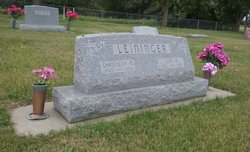
| Burial | : | Calvary Cemetery, Sutton, Clay County, USA |
| Coordinate | : | 40.5746994, -97.8636017 |
| Inscription | : | Father | Thy Will Be Done |
| Description | : | GEORGE LEININGER RITES WERE TUESDAY, RETIRED FARMER Funeral services were Tuesday at 10 a.m. for retired Clay county farmer, George M. S. Leininger, 80, who died Saturday at Mary Lanning hospital at Hastings. Rites were at St. Mary's Catholic Church, the Rev. Clement Siwinski officiating and burial in Calvary cemetery. The Kohler Mortuary was in charge. Rosary had been recited at the Kohler Mortuary on Monday evening. Mr. Leininger was born in Lincoln, Ill. and farmed in Clay county for many years before recently moving to Sutton. Survivors include his wife, Irene; two sons, Dr. Bernard Leininger... Read More |
frequently asked questions (FAQ):
-
Where is George Michael Stephenson Leininger's memorial?
George Michael Stephenson Leininger's memorial is located at: Calvary Cemetery, Sutton, Clay County, USA.
-
When did George Michael Stephenson Leininger death?
George Michael Stephenson Leininger death on 27 Dec 1969 in Hastings, Adams County, Nebraska, USA
-
Where are the coordinates of the George Michael Stephenson Leininger's memorial?
Latitude: 40.5746994
Longitude: -97.8636017
Family Members:
Parent

Spouse
Siblings
Children


Nearby Cemetories:
1. Calvary Cemetery
Sutton, Clay County, USA
Coordinate: 40.5746994, -97.8636017
2. Percival Family Lot
Saronville, Clay County, USA
Coordinate: 40.5824700, -97.9199400
3. Sutton Cemetery
Sutton, Clay County, USA
Coordinate: 40.6189003, -97.8644028
4. Saronville United Methodist Cemetery
Saronville, Clay County, USA
Coordinate: 40.6147100, -97.9188500
5. Saron Lutheran Church Cemetery
Saronville, Clay County, USA
Coordinate: 40.6110992, -97.9297028
6. Verona Danish Cemetery
Clay County, USA
Coordinate: 40.5685997, -97.9756012
7. Verona Swedish Cemetery
Clay County, USA
Coordinate: 40.5677986, -97.9764023
8. Free German Reformed Salem Church Cemetery
Fillmore County, USA
Coordinate: 40.6697220, -97.8227780
9. Fairview Cemetery
Fillmore County, USA
Coordinate: 40.4817009, -97.8133011
10. Chapel Grove Cemetery
Clay County, USA
Coordinate: 40.4660988, -97.8816986
11. Emmanuel Reformed Church Cemetery
School Creek Township, Clay County, USA
Coordinate: 40.6847220, -97.8811110
12. Marshall Union Evergreen Cemetery
Clay Center, Clay County, USA
Coordinate: 40.4880300, -97.9573000
13. Holy Cross Cemetery
Grafton, Fillmore County, USA
Coordinate: 40.6150017, -97.7108002
14. Grafton Cemetery
Grafton, Fillmore County, USA
Coordinate: 40.6157990, -97.7106018
15. Saint Marys Cemetery
Shickley, Fillmore County, USA
Coordinate: 40.4816700, -97.7295400
16. Eller Cemetery
Clay Center, Clay County, USA
Coordinate: 40.4956700, -98.0145700
17. Farmers Valley Cemetery
Hamilton County, USA
Coordinate: 40.7216988, -97.8533020
18. Clay Center Cemetery
Clay Center, Clay County, USA
Coordinate: 40.5325012, -98.0500031
19. Stockham Cemetery
Stockham, Hamilton County, USA
Coordinate: 40.7111015, -97.9408035
20. Prairieview Cemetery
Ong, Clay County, USA
Coordinate: 40.4235100, -97.9093400
21. Zion Lutheran Cemetery
Fillmore County, USA
Coordinate: 40.4668999, -97.7097015
22. Ong Cemetery
Ong, Clay County, USA
Coordinate: 40.4077988, -97.8367004
23. Lushton Cemetery
Lushton, York County, USA
Coordinate: 40.7125100, -97.7317100
24. Harvard Cemetery
Harvard, Clay County, USA
Coordinate: 40.6123047, -98.0920258