| Birth | : | 1863 San Bernardino, San Bernardino County, California, USA |
| Death | : | 1869 San Bernardino, San Bernardino County, California, USA |
| Burial | : | Devonshire Street Cemetery (Defunct), Sydney, City of Sydney, Australia |
| Coordinate | : | -33.8828080, 151.2066180 |
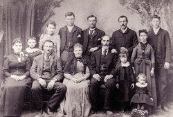
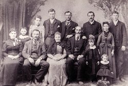
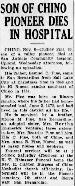
| Description | : | George's parents were: Samuel Cook Pine Sr., b. Jul. 30, 1825 in Stockholm Center, St. Lawrence County, NY. and d. Jan. 16, 1897 in San Bernardino County, CA. & Jane Morrison, b. Sep. 5, 1836 in Kingston, Frontenac County, Ontario, Canada and d. Nov. 26, 1913 in Chino, San Bernardino County, CA. Samuel Pine and Jane Morrison were married in 1855 in Salt Lake City, UT.. Samuel & Jane Pine's children were: 1. Samuel Cook Pine Jr., b. Dec. 26, 1856 in Salt Lake City, Salt Lake county, UT. and d. Mar. 24, 1919 in Chino, San Bernardino... Read More |
frequently asked questions (FAQ):
-
Where is George Pine's memorial?
George Pine's memorial is located at: Devonshire Street Cemetery (Defunct), Sydney, City of Sydney, Australia.
-
When did George Pine death?
George Pine death on 1869 in San Bernardino, San Bernardino County, California, USA
-
Where are the coordinates of the George Pine's memorial?
Latitude: -33.8828080
Longitude: 151.2066180
Family Members:
Parent
Siblings
Flowers:
Nearby Cemetories:
1. Devonshire Street Cemetery (Defunct)
Sydney, City of Sydney, Australia
Coordinate: -33.8828080, 151.2066180
2. Old Sydney Burial Ground
Sydney, City of Sydney, Australia
Coordinate: -33.8731750, 151.2063850
3. Saint Mary's Cathedral
Sydney, City of Sydney, Australia
Coordinate: -33.8708540, 151.2135820
4. Parish Church of Saint James
Sydney, City of Sydney, Australia
Coordinate: -33.8693760, 151.2111540
5. Royal Botanic Gardens
Sydney, City of Sydney, Australia
Coordinate: -33.8647440, 151.2170610
6. Camperdown Cemetery
Newtown, City of Sydney, Australia
Coordinate: -33.8942220, 151.1804900
7. Garden Island
Potts Point, City of Sydney, Australia
Coordinate: -33.8613635, 151.2280308
8. St Luke's Anglican Church
Enmore, Inner West Council, Australia
Coordinate: -33.8989218, 151.1700724
9. St. Peters Cooks River Cemetery
Saint Peters, Inner West Council, Australia
Coordinate: -33.9139390, 151.1775670
10. Saint Jude's Cemetery
Randwick, Randwick City, Australia
Coordinate: -33.9115460, 151.2417130
11. Pioneers Memorial Park
Leichhardt, Inner West Council, Australia
Coordinate: -33.8780800, 151.1575000
12. Mary MacKillop Memorial Chapel
North Sydney, North Sydney Council, Australia
Coordinate: -33.8388250, 151.2049160
13. Balmain Catholic Cemetery (Defunct)
Leichhardt, Inner West Council, Australia
Coordinate: -33.8797270, 151.1523730
14. Holy Trinity Church
Kingsford, Randwick City, Australia
Coordinate: -33.9267060, 151.2321180
15. St Thomas Becket Churchyard
Lewisham, Inner West Council, Australia
Coordinate: -33.8928760, 151.1480490
16. St David’s Presbyterian Cemetery
Haberfield, Inner West Council, Australia
Coordinate: -33.8823220, 151.1378500
17. St. Thomas Rest Park
Crows Nest, North Sydney Council, Australia
Coordinate: -33.8244490, 151.2063050
18. Botany Wesleyan Cemetery (Defunct)
Botany Bay, Bayside Council, Australia
Coordinate: -33.9421070, 151.1961480
19. Rawson Park
Mosman, Mosman Municipality, Australia
Coordinate: -33.8350640, 151.2504980
20. Randwick General Cemetery
South Coogee, Randwick City, Australia
Coordinate: -33.9295780, 151.2549810
21. Gore Hill Cemetery
St Leonards, North Sydney Council, Australia
Coordinate: -33.8229500, 151.1887590
22. St Aidan's Anglican Church
Longueville, Lane Cove Municipality, Australia
Coordinate: -33.8281510, 151.1709560
23. St. John's Anglican Church Cemetery
Ashfield, Inner West Council, Australia
Coordinate: -33.8817160, 151.1278730
24. St. Paul's Anglican Church Cemetery
Canterbury, Canterbury-Bankstown Council, Australia
Coordinate: -33.9081600, 151.1236000


