


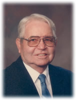
George W Mangold
| Birth | : | 30 May 1948 Buena Vista County, Iowa, USA |
| Death | : | 18 Jan 2012 Rapid City, Pennington County, South Dakota, USA |
| Burial | : | Barnes Township Cemetery, Linn Grove, Buena Vista County, USA |
| Coordinate | : | 42.8880997, -95.2397003 |
| Description | : | Hill City, SD dateline George W. Mangold, 63, Hill City, died Wednesday, January 18, 2012 at Rapid City Regional Hospital. He was born May 30, 1948 in Buena Vista County, IA to Floyd and Emogene (Wienands) Mangold. George grew up on a farm in rural Linn Grove, where he developed his interest in agriculture. He was baptized and confirmed in Trinity Lutheran Church in Linn Grove. He attended and graduated from Sioux Valley Community School, attended Buena Vista College and Graduated from South Dakota State University, first with a degree in Agronomy and later with a teaching degree in Agronomy.... Read More |
frequently asked questions (FAQ):
-
Where is George W Mangold's memorial?
George W Mangold's memorial is located at: Barnes Township Cemetery, Linn Grove, Buena Vista County, USA.
-
When did George W Mangold death?
George W Mangold death on 18 Jan 2012 in Rapid City, Pennington County, South Dakota, USA
-
Where are the coordinates of the George W Mangold's memorial?
Latitude: 42.8880997
Longitude: -95.2397003
Family Members:
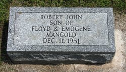
Parent

Siblings
Flowers:


Nearby Cemetories:
1. Barnes Township Cemetery
Linn Grove, Buena Vista County, USA
Coordinate: 42.8880997, -95.2397003
2. Douglas Township Cemetery
Clay County, USA
Coordinate: 42.9255981, -95.2450027
3. Little Sioux Valley Cemetery
Rembrandt, Buena Vista County, USA
Coordinate: 42.8375015, -95.2074966
4. Lone Tree Cemetery
Sioux Rapids, Buena Vista County, USA
Coordinate: 42.8819008, -95.1492004
5. Saint Josephs Cemetery
Sioux Rapids, Buena Vista County, USA
Coordinate: 42.8883018, -95.1324997
6. Oakland Cemetery
Peterson, Clay County, USA
Coordinate: 42.9281006, -95.3432999
7. Fanny Fern Cemetery
Clay County, USA
Coordinate: 42.9530983, -95.1607971
8. Zion Methodist Cemetery
Clay County, USA
Coordinate: 42.9808006, -95.2497025
9. Saint Johannes Cemetery
Brooke Township, Buena Vista County, USA
Coordinate: 42.8662758, -95.3669968
10. Plainview Cemetery
Alta, Buena Vista County, USA
Coordinate: 42.8087100, -95.3280200
11. Burr Oak Cemetery
Herdland Township, Clay County, USA
Coordinate: 42.9235992, -95.0907974
12. Lincoln Cemetery
Rossie, Clay County, USA
Coordinate: 43.0111008, -95.2313995
13. Liberty Cemetery
Greenville, Clay County, USA
Coordinate: 42.9897003, -95.1417007
14. Immanuel Lutheran Church Cemetery
Aurelia, Cherokee County, USA
Coordinate: 42.8165000, -95.3885000
15. Elk Cemetery
Elk Township, Buena Vista County, USA
Coordinate: 42.7641983, -95.3094025
16. Willow Creek Cemetery
Royal, Clay County, USA
Coordinate: 43.0214005, -95.2885971
17. Hannibal H Waterman Cemetery
O'Brien County, USA
Coordinate: 42.9375530, -95.4170760
18. Osborn Cemetery
Webb, Clay County, USA
Coordinate: 42.9346918, -95.0608244
19. Haight Family Farm Cemetery
Aurelia, Cherokee County, USA
Coordinate: 42.7778400, -95.3781060
20. Fred Feldman Grave
Waterman Township, O'Brien County, USA
Coordinate: 42.9178590, -95.4433340
21. Clay Center Cemetery
Royal, Clay County, USA
Coordinate: 43.0410995, -95.3272018
22. Lincoln Township Cemetery
Buena Vista County, USA
Coordinate: 42.7413000, -95.1282000
23. Swedish Lutheran Cemetery
Royal, Clay County, USA
Coordinate: 43.0683000, -95.2350000
24. Poland Township Cemetery
Marathon, Buena Vista County, USA
Coordinate: 42.8610992, -94.9916992