
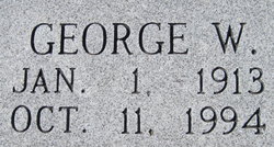
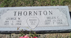
George W. Thornton
| Birth | : | 1 Jan 1913 |
| Death | : | 11 Oct 1994 |
| Burial | : | Rose Hill Cemetery, Berrien Springs, Berrien County, USA |
| Coordinate | : | 41.9331017, -86.3403015 |
| Plot | : | Thornton |
| Description | : | THORNTON, GEORGE W. Thornton, George W., 81, retired farmer, died Tuesday, Oct. 11, 1994. Service 11 a.m. Friday, Chicago Mound Cemetery, rural Emporia. Survivors: sons, Noble of Hartford, George A. of Sedalia, Mo.; sister, Ruth Ream of Kansas City, Kan.; four grandchildren; four great-grandchildren. Memorials have been established with the Emporia Friends of the Zoo and Sacred Heart Catholic Church. Roberts-Blue-Barnett Funeral Home. (Wichita Eagle ~ 12 Oct 1994) |
frequently asked questions (FAQ):
-
Where is George W. Thornton's memorial?
George W. Thornton's memorial is located at: Rose Hill Cemetery, Berrien Springs, Berrien County, USA.
-
When did George W. Thornton death?
George W. Thornton death on 11 Oct 1994 in
-
Where are the coordinates of the George W. Thornton's memorial?
Latitude: 41.9331017
Longitude: -86.3403015
Family Members:
Spouse
Children
Flowers:


Nearby Cemetories:
1. Rose Hill Cemetery
Berrien Springs, Berrien County, USA
Coordinate: 41.9331017, -86.3403015
2. Long Lake Cemetery
Berrien Springs, Berrien County, USA
Coordinate: 41.9185982, -86.3125000
3. Berrien County Poor Farm Cemetery
Berrien Springs, Berrien County, USA
Coordinate: 41.9539700, -86.3028900
4. Burke Cemetery
Berrien Springs, Berrien County, USA
Coordinate: 41.9216995, -86.3974991
5. Union Cemetery
Berrien Center, Berrien County, USA
Coordinate: 41.9299431, -86.2727356
6. Colvin Cemetery
Buchanan, Berrien County, USA
Coordinate: 41.8986110, -86.3944440
7. Oak Grove Cemetery
Oronoko, Berrien County, USA
Coordinate: 41.9241982, -86.4122009
8. Maple Grove Cemetery
Eau Claire, Berrien County, USA
Coordinate: 41.9719009, -86.2872009
9. Caldwell Cemetery
Eau Claire, Berrien County, USA
Coordinate: 41.9860992, -86.2861023
10. Sherwood Cemetery
Buchanan, Berrien County, USA
Coordinate: 41.8669440, -86.3636110
11. Lett Cemetery
Sodus, Berrien County, USA
Coordinate: 42.0038890, -86.3447220
12. Salem Cemetery
Oronoko Township, Berrien County, USA
Coordinate: 41.9644012, -86.4278030
13. Morris Chapel Cemetery
Niles, Berrien County, USA
Coordinate: 41.9063880, -86.2463880
14. Benton Cemetery
Niles, Berrien County, USA
Coordinate: 41.8542190, -86.3501790
15. Feather Cemetery
Hinchman, Berrien County, USA
Coordinate: 41.9720955, -86.4356689
16. Mount Pleasant Cemetery
Sodus Township, Berrien County, USA
Coordinate: 42.0194016, -86.3581009
17. Robert Farry Cemetery
Eau Claire, Berrien County, USA
Coordinate: 42.0002778, -86.2619444
18. Hinman Cemetery
Baroda Township, Berrien County, USA
Coordinate: 41.9272003, -86.4597015
19. Boyle Cemetery
Oronoko, Berrien County, USA
Coordinate: 41.9013889, -86.4527778
20. Johnson Cemetery
Niles, Berrien County, USA
Coordinate: 41.8594440, -86.2691660
21. Harrah Road Cemetery
Niles, Berrien County, USA
Coordinate: 41.8425000, -86.3058333
22. Rodgers Cemetery
Pokagon, Cass County, USA
Coordinate: 41.9169365, -86.2149947
23. Franklin Cemetery
Berrien Township, Berrien County, USA
Coordinate: 41.9711110, -86.2236110
24. Virginians Burying Ground
Buchanan, Berrien County, USA
Coordinate: 41.8373070, -86.3694077