
| Birth | : | 23 May 1846 New Jersey, USA |
| Death | : | 13 Aug 1940 Sacramento, Sacramento County, California, USA |
| Burial | : | East Lawn Memorial Park, Sacramento, Sacramento County, USA |
| Coordinate | : | 38.5612960, -121.4492760 |
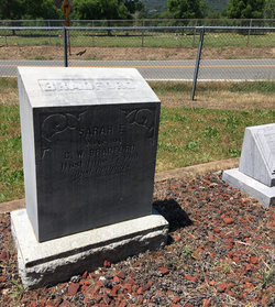
| Description | : | George was one of six children born to John Harrison Bradford and Caroline Ward. He married Ellen Catherine Martin in Colusa County January 1, 1875. They had 3 sons. Louis, John and Delbert. George and Ellen divorced sometime before 1894. In November of 1902 George married Sarah Emma Rantz Adams, widow of Lorenzo Theodore Adams and daughter of Daniel and Mary J. Kipp Rantz. George and Sarah were living in Upper Lake, Lake Co., CA with an adopted daughter Irene and Sarahs son Lorenzo Adams when Sarah died June 15, 1910. On November 3, 1914 in Lake... Read More |
frequently asked questions (FAQ):
-
Where is George Ward Bradford's memorial?
George Ward Bradford's memorial is located at: East Lawn Memorial Park, Sacramento, Sacramento County, USA.
-
When did George Ward Bradford death?
George Ward Bradford death on 13 Aug 1940 in Sacramento, Sacramento County, California, USA
-
Where are the coordinates of the George Ward Bradford's memorial?
Latitude: 38.5612960
Longitude: -121.4492760
Family Members:
Spouse

Children
Flowers:


Nearby Cemetories:
1. East Lawn Memorial Park
Sacramento, Sacramento County, USA
Coordinate: 38.5612960, -121.4492760
2. New Helvetia Cemetery (Defunct)
Sacramento, Sacramento County, USA
Coordinate: 38.5731600, -121.4639900
3. Trinity Episcopal Cathedral Columbarium
Sacramento, Sacramento County, USA
Coordinate: 38.5705500, -121.4723770
4. Saint Joseph Cemetery
Sacramento, Sacramento County, USA
Coordinate: 38.5574989, -121.4835968
5. Pho Minh Temple Columbarium
Sacramento, Sacramento County, USA
Coordinate: 38.5340100, -121.4769000
6. Saint Mary's Catholic Cemetery and Mausoleum
Sacramento, Sacramento County, USA
Coordinate: 38.5298900, -121.4261200
7. California State Capitol
Sacramento, Sacramento County, USA
Coordinate: 38.5760994, -121.4931488
8. Sacramento County Hospital Cemetery
Sacramento, Sacramento County, USA
Coordinate: 38.5289300, -121.4239100
9. Buddhist Church of Sacramento Nokotsudo
Sacramento, Sacramento County, USA
Coordinate: 38.5639300, -121.4978400
10. Russian Orthodox Cemetery
Sacramento, Sacramento County, USA
Coordinate: 38.5268800, -121.4244300
11. Sacramento County Cemetery
Sacramento County, USA
Coordinate: 38.5267900, -121.4233700
12. Sacramento City Cemetery
Sacramento, Sacramento County, USA
Coordinate: 38.5636864, -121.5009537
13. Odd Fellows Lawn Cemetery and Mausoleum
Sacramento, Sacramento County, USA
Coordinate: 38.5585000, -121.5011000
14. Sacramento County Veterans Memorial Cemetery
Sacramento, Sacramento County, USA
Coordinate: 38.5252838, -121.4239120
15. National Shrine of Our Lady of Guadalupe Crypt
Sacramento, Sacramento County, USA
Coordinate: 38.5704800, -121.5014400
16. Holy Ascension Russian Orthodox Cemetery
Sacramento, Sacramento County, USA
Coordinate: 38.5846212, -121.4936736
17. Masonic Lawn Cemetery
Sacramento, Sacramento County, USA
Coordinate: 38.5604720, -121.5032600
18. Sunset Hill Cemetery
Sacramento, Sacramento County, USA
Coordinate: 38.5608000, -121.5037300
19. Saint Rose Cemetery (Defunct)
Sacramento, Sacramento County, USA
Coordinate: 38.5208015, -121.4672012
20. Sacramento Memorial Lawn Cemetery
Sacramento, Sacramento County, USA
Coordinate: 38.5146484, -121.4380341
21. Home of Peace Cemetery
Sacramento, Sacramento County, USA
Coordinate: 38.5137558, -121.4382782
22. Tinh Xa Ngoc An Temple Columbarium
Sacramento, Sacramento County, USA
Coordinate: 38.5190200, -121.4159500
23. Elder Creek Cemetery
Florin, Sacramento County, USA
Coordinate: 38.5111008, -121.4169006
24. Kim Quang Temple Columbarium
Sacramento, Sacramento County, USA
Coordinate: 38.5996600, -121.3904700