
| Birth | : | 6 Jan 1857 Arkansas, USA |
| Death | : | 5 Feb 1930 Sacramento, Sacramento County, California, USA |
| Burial | : | East Lawn Memorial Park, Sacramento, Sacramento County, USA |
| Coordinate | : | 38.5612960, -121.4492760 |
| Plot | : | Section 2 |
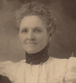
| Description | : | OBITUARY-SACRAMENTO BEE, THURSDAY, FEBRUARY 6, 1930, PAGE 5/7 BIRD-Entered into rest in this city, February 5th, 1930, Ellen C. Bird, beloved wife of the late John W. Bird, mother of Louie M., John D., and Delbert L. Bradford, sister of John L. Martin and Tennessee Corrigan, a native of Tennessee aged 74 years and 1 month. Friends are welcome at the home of Andrews and Greilich, 1700 "O" Street, until 10 A.M. Saturday, and are respectfully invited to attend the funeral at East Lawn Chapel where services will be held at 2 P. M. under the auspices of Rainbow Chapter... Read More |
frequently asked questions (FAQ):
-
Where is Ellen Catherine Martin Bird's memorial?
Ellen Catherine Martin Bird's memorial is located at: East Lawn Memorial Park, Sacramento, Sacramento County, USA.
-
When did Ellen Catherine Martin Bird death?
Ellen Catherine Martin Bird death on 5 Feb 1930 in Sacramento, Sacramento County, California, USA
-
Where are the coordinates of the Ellen Catherine Martin Bird's memorial?
Latitude: 38.5612960
Longitude: -121.4492760
Family Members:
Parent

Spouse
Siblings
Children
Flowers:


Nearby Cemetories:
1. East Lawn Memorial Park
Sacramento, Sacramento County, USA
Coordinate: 38.5612960, -121.4492760
2. New Helvetia Cemetery (Defunct)
Sacramento, Sacramento County, USA
Coordinate: 38.5731600, -121.4639900
3. Trinity Episcopal Cathedral Columbarium
Sacramento, Sacramento County, USA
Coordinate: 38.5705500, -121.4723770
4. Saint Joseph Cemetery
Sacramento, Sacramento County, USA
Coordinate: 38.5574989, -121.4835968
5. Pho Minh Temple Columbarium
Sacramento, Sacramento County, USA
Coordinate: 38.5340100, -121.4769000
6. Saint Mary's Catholic Cemetery and Mausoleum
Sacramento, Sacramento County, USA
Coordinate: 38.5298900, -121.4261200
7. California State Capitol
Sacramento, Sacramento County, USA
Coordinate: 38.5760994, -121.4931488
8. Sacramento County Hospital Cemetery
Sacramento, Sacramento County, USA
Coordinate: 38.5289300, -121.4239100
9. Buddhist Church of Sacramento Nokotsudo
Sacramento, Sacramento County, USA
Coordinate: 38.5639300, -121.4978400
10. Russian Orthodox Cemetery
Sacramento, Sacramento County, USA
Coordinate: 38.5268800, -121.4244300
11. Sacramento County Cemetery
Sacramento County, USA
Coordinate: 38.5267900, -121.4233700
12. Sacramento City Cemetery
Sacramento, Sacramento County, USA
Coordinate: 38.5636864, -121.5009537
13. Odd Fellows Lawn Cemetery and Mausoleum
Sacramento, Sacramento County, USA
Coordinate: 38.5585000, -121.5011000
14. Sacramento County Veterans Memorial Cemetery
Sacramento, Sacramento County, USA
Coordinate: 38.5252838, -121.4239120
15. National Shrine of Our Lady of Guadalupe Crypt
Sacramento, Sacramento County, USA
Coordinate: 38.5704800, -121.5014400
16. Holy Ascension Russian Orthodox Cemetery
Sacramento, Sacramento County, USA
Coordinate: 38.5846212, -121.4936736
17. Masonic Lawn Cemetery
Sacramento, Sacramento County, USA
Coordinate: 38.5604720, -121.5032600
18. Sunset Hill Cemetery
Sacramento, Sacramento County, USA
Coordinate: 38.5608000, -121.5037300
19. Saint Rose Cemetery (Defunct)
Sacramento, Sacramento County, USA
Coordinate: 38.5208015, -121.4672012
20. Sacramento Memorial Lawn Cemetery
Sacramento, Sacramento County, USA
Coordinate: 38.5146484, -121.4380341
21. Home of Peace Cemetery
Sacramento, Sacramento County, USA
Coordinate: 38.5137558, -121.4382782
22. Tinh Xa Ngoc An Temple Columbarium
Sacramento, Sacramento County, USA
Coordinate: 38.5190200, -121.4159500
23. Elder Creek Cemetery
Florin, Sacramento County, USA
Coordinate: 38.5111008, -121.4169006
24. Kim Quang Temple Columbarium
Sacramento, Sacramento County, USA
Coordinate: 38.5996600, -121.3904700