
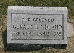

Gerald Bee Noland
| Birth | : | 5 Feb 1911 Oak Hill, Clay County, Kansas, USA |
| Death | : | 15 Jan 1938 Bristol, Bristol City, Virginia, USA |
| Burial | : | Rose Meron Cemetery, Oak Hill, Clay County, USA |
| Coordinate | : | 39.2194700, -97.3338900 |
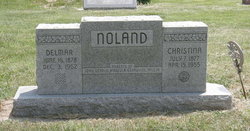
| Description | : | Son of Delmar W. and Christina Ann (French) Noland. Married in 1929, to Elsie Modean. They were the parents of one daughter, Patricia. He was one of the nation's leading wrestlers. A month prior to his death, he suffered broken ribs and a blow on the head, when he fell from the ring. His death was partly attributed to inflamation of the brain caused by a blow or fall. He also had been diagnosed with smallpox and later developed pheumonia. |
frequently asked questions (FAQ):
-
Where is Gerald Bee Noland's memorial?
Gerald Bee Noland's memorial is located at: Rose Meron Cemetery, Oak Hill, Clay County, USA.
-
When did Gerald Bee Noland death?
Gerald Bee Noland death on 15 Jan 1938 in Bristol, Bristol City, Virginia, USA
-
Where are the coordinates of the Gerald Bee Noland's memorial?
Latitude: 39.2194700
Longitude: -97.3338900
Family Members:
Parent

Spouse
Siblings

Children

Flowers:


Nearby Cemetories:
1. Rose Meron Cemetery
Oak Hill, Clay County, USA
Coordinate: 39.2194700, -97.3338900
2. Pleasant Valley Cemetery
Oak Hill, Clay County, USA
Coordinate: 39.2468987, -97.2889023
3. Wesleyan Cemetery
Oak Hill, Clay County, USA
Coordinate: 39.2268982, -97.2572021
4. Mount Liberty Church Cemetery
Ottawa County, USA
Coordinate: 39.2489400, -97.4356200
5. Swartwood Cemetery
Longford, Clay County, USA
Coordinate: 39.1323200, -97.3431500
6. Shields Cemetery
Clay County, USA
Coordinate: 39.3208008, -97.3507996
7. Table Mound Cemetery
Idana, Clay County, USA
Coordinate: 39.3141300, -97.2792300
8. Keystone Cemetery
Manchester, Dickinson County, USA
Coordinate: 39.1185989, -97.2917023
9. Hebron Cemetery
Clay County, USA
Coordinate: 39.3213800, -97.2601400
10. Vine Creek Cemetery
Ottawa County, USA
Coordinate: 39.1194000, -97.4180984
11. Athelstane Cemetery
Athelstane Township, Clay County, USA
Coordinate: 39.1768990, -97.1753006
12. Pleasant Ridge Cemetery
Clay County, USA
Coordinate: 39.2789001, -97.1841965
13. Miltonvale Cemetery
Miltonvale, Cloud County, USA
Coordinate: 39.3358002, -97.4447021
14. White Cloud Cemetery
Manchester, Dickinson County, USA
Coordinate: 39.0744019, -97.3525009
15. Idana Cemetery
Idana, Clay County, USA
Coordinate: 39.3574500, -97.2693300
16. Zion Lutheran Cemetery
Clay County, USA
Coordinate: 39.2928009, -97.1557999
17. Mizpah Cemetery
Clay County, USA
Coordinate: 39.2057800, -97.1238500
18. Smith Grave
Miltonvale, Cloud County, USA
Coordinate: 39.3645300, -97.4308700
19. Fairview Cemetery
Lamar, Ottawa County, USA
Coordinate: 39.2928009, -97.5299988
20. Ackley Cemetery
Ottawa County, USA
Coordinate: 39.0893160, -97.4797040
21. Greenridge Cemetery
Dickinson County, USA
Coordinate: 39.1199989, -97.1433029
22. Henry Cemetery
Buckeye, Dickinson County, USA
Coordinate: 39.0828018, -97.1857986
23. Prairiedale Cemetery
Talmage, Dickinson County, USA
Coordinate: 39.0471992, -97.2652969
24. Republican City Cemetery
Clay Center, Clay County, USA
Coordinate: 39.3431015, -97.1628036