
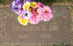
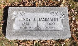
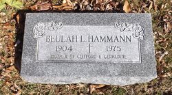
Geraldine Roberta Hammann Lee
| Birth | : | 7 Jul 1941 Muscatine, Muscatine County, Iowa, USA |
| Death | : | 2 Feb 1975 Muscatine, Muscatine County, Iowa, USA |
| Burial | : | Saint Alphonsus Cemetery, Saint Joseph, Daviess County, USA |
| Coordinate | : | 37.6948800, -87.3247700 |
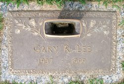
| Description | : | Taken from the Muscatine Journal Feb. 3, 1975. Mrs. Gary R. (Geraldine) Lee, 33, Rt. 4, Muscatine, died at 8:05 a. m. Sunday at Muscatine General Hospital following an extended illness. Funeral services will be held at at the Letts Independent Church with Rev. Walter Glasscock officiating. Interment will be at Memorial Park Cemetery. Born July 7, 1941, at Muscatine, she was the daughter of Henry and Beulah McCallan Hammann, and had been a life resident of this community. Her marriage to Gary R. Lee, took place April 24, 1960, at Muscatine. She was a member of the Letts Independent church. Survivors include her... Read More |
frequently asked questions (FAQ):
-
Where is Geraldine Roberta Hammann Lee's memorial?
Geraldine Roberta Hammann Lee's memorial is located at: Saint Alphonsus Cemetery, Saint Joseph, Daviess County, USA.
-
When did Geraldine Roberta Hammann Lee death?
Geraldine Roberta Hammann Lee death on 2 Feb 1975 in Muscatine, Muscatine County, Iowa, USA
-
Where are the coordinates of the Geraldine Roberta Hammann Lee's memorial?
Latitude: 37.6948800
Longitude: -87.3247700
Family Members:
Parent
Spouse
Flowers:


Nearby Cemetories:
1. Saint Alphonsus Cemetery
Saint Joseph, Daviess County, USA
Coordinate: 37.6948800, -87.3247700
2. Mount Saint Joseph Cemetery
Maple Mount, Daviess County, USA
Coordinate: 37.6931000, -87.3216570
3. Travis Cemetery
Saint Joseph, Daviess County, USA
Coordinate: 37.6777992, -87.3469009
4. Jewell Cemetery
Saint Joseph, Daviess County, USA
Coordinate: 37.6804199, -87.3699799
5. McCain Cemetery
Curdsville, Daviess County, USA
Coordinate: 37.7322006, -87.3480988
6. Old Macedonia Cemetery
Panther, Daviess County, USA
Coordinate: 37.6530000, -87.3042000
7. Pleasant Hill Cumberland Presb. Church Cemetery
Elba, McLean County, USA
Coordinate: 37.6660690, -87.3741989
8. Calhoon Curdsville Cemetery
Curdsville, Daviess County, USA
Coordinate: 37.7440000, -87.3020000
9. Welden Cemetery
Hebbardsville, Henderson County, USA
Coordinate: 37.7503200, -87.3253800
10. Old Macedonia Cemetery
Daviess County, USA
Coordinate: 37.6489000, -87.2822000
11. New Salem Primitive Baptist Church Cemetery
Beech Grove, McLean County, USA
Coordinate: 37.6372795, -87.3351974
12. Saint Raphael Cemetery
West Louisville, Daviess County, USA
Coordinate: 37.7033900, -87.2489000
13. Delaware Church Cemetery
Delaware, Daviess County, USA
Coordinate: 37.6859130, -87.4041040
14. Saint Raphael Original Log Church and Cemetery
West Louisville, Daviess County, USA
Coordinate: 37.7009600, -87.2442900
15. Mount Liberty Baptist Church Cemetery
Wyman, McLean County, USA
Coordinate: 37.6312256, -87.3094635
16. Hitchcock Family Cemetery
Sorgho, Daviess County, USA
Coordinate: 37.7423261, -87.2686245
17. Beulah General Baptist Church Cemetery
McLean County, USA
Coordinate: 37.6285706, -87.3355026
18. Little Flock Cemetery
West Louisville, Daviess County, USA
Coordinate: 37.6369900, -87.2733300
19. Hazelwood Cemetery
Hebbardsville, Henderson County, USA
Coordinate: 37.7596110, -87.3692780
20. Little Flock Baptist Cemetery
Sorgho, Daviess County, USA
Coordinate: 37.7573600, -87.2687700
21. Mount Zion Methodist Episcopal Church Cemetery
Panther, Daviess County, USA
Coordinate: 37.6638700, -87.2325500
22. Sorgho Baptist Church Cemetery
Sorgho, Daviess County, USA
Coordinate: 37.7552700, -87.2588600
23. Brushy Fork Cemetery
Panther, Daviess County, USA
Coordinate: 37.6375999, -87.2545013
24. Bethel Cemetery
Hebbardsville, Henderson County, USA
Coordinate: 37.7684898, -87.3658829