
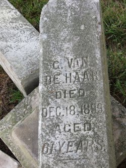
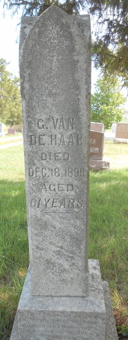
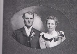
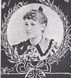
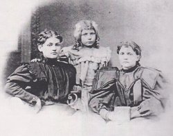
Gerrit M. VanDe Haar
| Birth | : | 22 Dec 1833 Renkum, Renkum Municipality, Gelderland, Netherlands |
| Death | : | 18 Dec 1899 Mahaska County, Iowa, USA |
| Burial | : | Carinya Gardens, Mount Gambier, Mount Gambier City, Australia |
| Coordinate | : | -37.8370330, 140.7494970 |
| Inscription | : | aged 61 years |
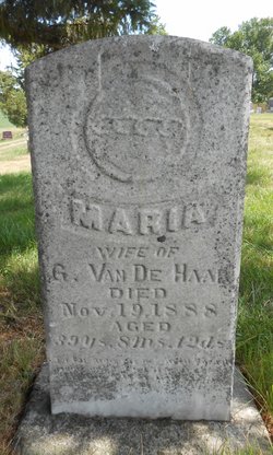
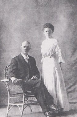
| Description | : | Gerrit and Maria deJong were married September 10, 1868 by Rev Egbert Winter, pastor of the First Reformed Church of Pella, Iowa. They had ten children - Elizabeth (Lizzie), Arie, Peter, Gysbertha, Cornelius (Neal), Everta (Eva), Dora, William, Martinus, and Greta. They lived on several farms in the Black Oak area. In 1880 they had 240 acres and had horses, cattle, swine, poultry and raised wheat, corn, oats, Irish potatoes, hay. They made butter, cheese, and molasses. Maria passed away in 1888 shortly after the birth of Greta. Gerrit lived on for another 11... Read More |
frequently asked questions (FAQ):
-
Where is Gerrit M. VanDe Haar's memorial?
Gerrit M. VanDe Haar's memorial is located at: Carinya Gardens, Mount Gambier, Mount Gambier City, Australia.
-
When did Gerrit M. VanDe Haar death?
Gerrit M. VanDe Haar death on 18 Dec 1899 in Mahaska County, Iowa, USA
-
Where are the coordinates of the Gerrit M. VanDe Haar's memorial?
Latitude: -37.8370330
Longitude: 140.7494970
Family Members:
Spouse
Children

Flowers:


Nearby Cemetories:
1. Pioneer Park
Mount Gambier, Mount Gambier City, Australia
Coordinate: -37.8348290, 140.7840010
2. Mieschel Park
Mount Gambier, Mount Gambier City, Australia
Coordinate: -37.8374980, 140.7855890
3. Lake Terrace Cemetery
Mount Gambier, Mount Gambier City, Australia
Coordinate: -37.8425950, 140.7854720
4. Port MacDonnell Lighthouse Cemetery
Port MacDonnell, District Council of Grant, Australia
Coordinate: -38.0558330, 140.6630560
5. Kalangadoo Cemetery
Kalangadoo, Wattle Range Council, Australia
Coordinate: -37.5694190, 140.7045780
6. Nelson Cemetery
Nelson, Glenelg Shire, Australia
Coordinate: -38.0359977, 141.0123516
7. Strathdownie Cemetery
Strathdownie, Glenelg Shire, Australia
Coordinate: -37.7174000, 141.1676280
8. Millicent Cemetery
Millicent, Wattle Range Council, Australia
Coordinate: -37.6184335, 140.3770980
9. Dartmoor Cemetery
Dartmoor, Glenelg Shire, Australia
Coordinate: -37.9148220, 141.2491380
10. Heathfield Cemetery
Lake Mundi, Glenelg Shire, Australia
Coordinate: -37.5713233, 141.1436213
11. Penola Cemetery
Penola, Wattle Range Council, Australia
Coordinate: -37.4009210, 140.8362800
12. Drik Drik Cemetery
Drik Drik, Glenelg Shire, Australia
Coordinate: -37.9858333, 141.2952778
13. Penola Old Cemetery
Penola, Wattle Range Council, Australia
Coordinate: -37.3670740, 140.8412400
14. Casterton Old Cemetery
Casterton, Glenelg Shire, Australia
Coordinate: -37.5948850, 141.3700380
15. Casterton Cemetery
Casterton, Glenelg Shire, Australia
Coordinate: -37.5992440, 141.4088270
16. Digby Cemetery
Digby, Glenelg Shire, Australia
Coordinate: -37.8196840, 141.5040810
17. Sandford Cemetery
Sandford, Glenelg Shire, Australia
Coordinate: -37.6290998, 141.4562576
18. Dergholm Cemetery
Dergholm, West Wimmera Shire, Australia
Coordinate: -37.3717520, 141.2253000
19. Rifle Ranges Pastoral Run
Digby, Glenelg Shire, Australia
Coordinate: -37.7813184, 141.5104222
20. Merino Cemetery
Merino, Glenelg Shire, Australia
Coordinate: -37.6908180, 141.5434050
21. Beachport Cemetery
Beachport, Wattle Range Council, Australia
Coordinate: -37.4725340, 140.0475120
22. Hotspur Cemetery
Hotspur, Glenelg Shire, Australia
Coordinate: -37.9297580, 141.5866650
23. Corkhill Station Cemetery
Cape Bridgewater, Glenelg Shire, Australia
Coordinate: -38.3451060, 141.4092120
24. Cape Bridgewater Cemetery
Cape Bridgewater Lower, Glenelg Shire, Australia
Coordinate: -38.3396480, 141.4298350