
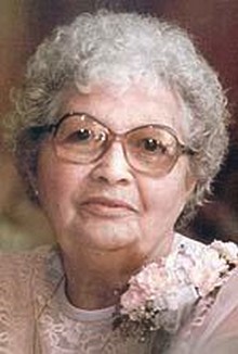

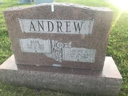
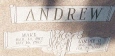
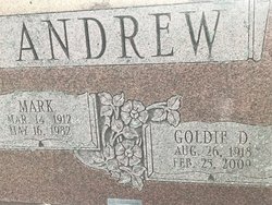
Goldie D Manning Andrew
| Birth | : | 26 Aug 1918 Mount Hope, Adams County, Pennsylvania, USA |
| Death | : | 25 Feb 2009 Maryland, USA |
| Burial | : | Mount Olivet Catholic Cemetery, San Rafael, Marin County, USA |
| Coordinate | : | 38.0024986, -122.5397034 |
| Plot | : | Section nearest Church |
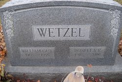
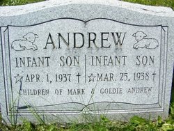
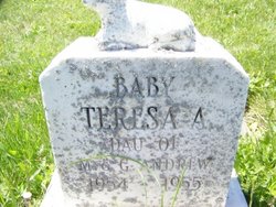
| Description | : | The daughter of Mary Ellen (Snyder) and John Michael Manning. Goldie loved her family, and enjoyed spending time with all her children, grandchildren, great-grandchildren, and great-great-grandchildren. Surviving are two daughters, Nancy Lee Tyler and husband Frank, and Patricia Jean Rosensteel and husband Robert Sr., both of Emmitsburg; six grandchildren, Francis Topper Jr., Karen McDannell, Susan Swartz, Ronald Topper, Robert Rosensteel Jr., and Laura Money; 12 great-grandchildren; four great-great-grandchildren; several nieces and nephews; five step-grandchildren; and 11 step-great-grandchildren. She was also predeceased by one daughter, Teresa Arlene Andrew, and by two infant sons; and by four siblings, Rita Wetzel, Teresa Mort,... Read More |
frequently asked questions (FAQ):
-
Where is Goldie D Manning Andrew's memorial?
Goldie D Manning Andrew's memorial is located at: Mount Olivet Catholic Cemetery, San Rafael, Marin County, USA.
-
When did Goldie D Manning Andrew death?
Goldie D Manning Andrew death on 25 Feb 2009 in Maryland, USA
-
Where are the coordinates of the Goldie D Manning Andrew's memorial?
Latitude: 38.0024986
Longitude: -122.5397034
Family Members:
Parent

Spouse
Siblings

Children

Flowers:


Nearby Cemetories:
1. Mount Olivet Catholic Cemetery
San Rafael, Marin County, USA
Coordinate: 38.0024986, -122.5397034
2. Mount Tamalpais Cemetery
San Rafael, Marin County, USA
Coordinate: 37.9861984, -122.5544891
3. Mission San Rafael Arcangel Cemetery
San Rafael, Marin County, USA
Coordinate: 37.9744330, -122.5280570
4. Marin County Farm Cemetery
Marin County, USA
Coordinate: 38.0285500, -122.5652530
5. Saint Vincents Orphanage Cemetery
San Rafael, Marin County, USA
Coordinate: 38.0355800, -122.5334550
6. First Presbyterian Church Memorial Garden
San Anselmo, Marin County, USA
Coordinate: 37.9703310, -122.5667860
7. Montgomery Memorial Chapel Crypt
San Anselmo, Marin County, USA
Coordinate: 37.9687940, -122.5638630
8. San Quentin Prison Cemetery
San Rafael, Marin County, USA
Coordinate: 37.9436480, -122.4883760
9. Druid Heights Burial Site
Mill Valley, Marin County, USA
Coordinate: 37.8892100, -122.5647100
10. Pioneer Memorial Cemetery
Novato, Marin County, USA
Coordinate: 38.1132532, -122.5902599
11. Valley Memorial Park
Novato, Marin County, USA
Coordinate: 38.1204300, -122.5436300
12. Fernwood Cemetery
Mill Valley, Marin County, USA
Coordinate: 37.8767014, -122.5231018
13. St. Stephen's Episcopal Church Memorial Garden
Belvedere, Marin County, USA
Coordinate: 37.8767515, -122.4712901
14. Saint Mary Magdalene Catholic Church Cemetery
Bolinas, Marin County, USA
Coordinate: 37.9212570, -122.6938858
15. Bolinas Cemetery
Bolinas, Marin County, USA
Coordinate: 37.9212600, -122.6938900
16. Taylor Cemetery
Lagunitas, Marin County, USA
Coordinate: 38.0272580, -122.7346590
17. Saint Pauls Cemetery (Defunct)
San Pablo, Contra Costa County, USA
Coordinate: 37.9563332, -122.3430099
18. Angel Island Cemetery (defunct)
Tiburon, Marin County, USA
Coordinate: 37.8621830, -122.4325920
19. Salesian Cemetery
Richmond, Contra Costa County, USA
Coordinate: 37.9532650, -122.3401230
20. Sailors Cemetery
Sausalito, Marin County, USA
Coordinate: 37.8442390, -122.4774770
21. Saint Joseph Catholic Cemetery
San Pablo, Contra Costa County, USA
Coordinate: 37.9612700, -122.3336600
22. Rolling Hills Memorial Park
Richmond, Contra Costa County, USA
Coordinate: 37.9756012, -122.3146973
23. Olema Cemetery
Olema, Marin County, USA
Coordinate: 38.0313988, -122.7789001
24. Presidio of San Francisco Pet Cemetery
San Francisco, San Francisco County, USA
Coordinate: 37.8025490, -122.4671960