
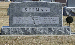
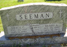
Grace C. Piel Seeman
| Birth | : | 30 Jul 1897 Adams County, Nebraska, USA |
| Death | : | 5 Sep 1990 Blue Hill, Webster County, Nebraska, USA |
| Burial | : | Mount Pleasant Cemetery, Mount Pleasant, Hunterdon County, USA |
| Coordinate | : | 40.5835267, -75.0536867 |
| Plot | : | NW section Lot 46 |
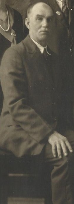
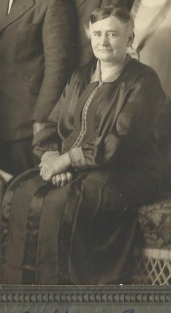
| Description | : | Obituary of Grace C. Seeman Grace C. (Piel) Seeman passed away September 5, 1990, at Bethesda Care Center in Blue Hill. She was born July 30, 1897 to John and Bertha (Steward) Piel in Adams County. She lived her entire life in Adams and Webster County. She attended School District 50 in Webster County. Grace married Henry A. Seeman February 17, 1926. On May 16, 1948, she was baptized and confirmed in Trinity Lutheran Church. They moved into Blue Hill from a farm near Rosemont in November 1959. Henry died on October 16, 1962. She lived in... Read More |
frequently asked questions (FAQ):
-
Where is Grace C. Piel Seeman's memorial?
Grace C. Piel Seeman's memorial is located at: Mount Pleasant Cemetery, Mount Pleasant, Hunterdon County, USA.
-
When did Grace C. Piel Seeman death?
Grace C. Piel Seeman death on 5 Sep 1990 in Blue Hill, Webster County, Nebraska, USA
-
Where are the coordinates of the Grace C. Piel Seeman's memorial?
Latitude: 40.5835267
Longitude: -75.0536867
Family Members:
Parent
Spouse

Siblings
Children

Flowers:


Nearby Cemetories:
1. Mount Pleasant Cemetery
Mount Pleasant, Hunterdon County, USA
Coordinate: 40.5835267, -75.0536867
2. Everittstown Methodist Cemetery
Everittstown, Hunterdon County, USA
Coordinate: 40.5655823, -75.0279922
3. Milford Union Cemetery
Milford, Hunterdon County, USA
Coordinate: 40.5667000, -75.0922012
4. Milford Christian Churchyard
Milford, Hunterdon County, USA
Coordinate: 40.5685425, -75.0972214
5. Pursell Burying Ground
Upper Black Eddy, Bucks County, USA
Coordinate: 40.5584410, -75.0933950
6. Robins Family Burying Ground
Pattenburg, Hunterdon County, USA
Coordinate: 40.6284027, -75.0432663
7. Oak Hill Golf Course Burial Ground
Holland, Hunterdon County, USA
Coordinate: 40.6061170, -75.1085940
8. Garrison-Tharp Cemetery
Pattenburg, Hunterdon County, USA
Coordinate: 40.6340294, -75.0494461
9. Saint Thomas Episcopal Church Cemetery
Pittstown, Hunterdon County, USA
Coordinate: 40.5606900, -74.9890000
10. Oak Summit Cemetery
Kingwood, Hunterdon County, USA
Coordinate: 40.5419000, -75.0051000
11. Erwin Family Cemetery
Erwinna, Bucks County, USA
Coordinate: 40.5279105, -75.0674030
12. Mount Salem Methodist Cemetery
Mount Salem, Hunterdon County, USA
Coordinate: 40.6057200, -74.9831300
13. Upper Tinicum Cemetery
Upper Black Eddy, Bucks County, USA
Coordinate: 40.5292650, -75.0822933
14. Frenchtown Cemetery
Frenchtown, Hunterdon County, USA
Coordinate: 40.5237503, -75.0605545
15. Pattenburg United Methodist Church Cemetery
Pattenburg, Hunterdon County, USA
Coordinate: 40.6355800, -75.0126900
16. Baptistown Cemetery
Baptistown, Hunterdon County, USA
Coordinate: 40.5240100, -75.0061190
17. Bethlehem Baptist Cemetery
Pattenburg, Hunterdon County, USA
Coordinate: 40.6418076, -74.9937515
18. Bloomsbury Methodist Churchyard
Bloomsbury, Hunterdon County, USA
Coordinate: 40.6536522, -75.0852127
19. Bloomsbury Presbyterian Cemetery
Bloomsbury, Hunterdon County, USA
Coordinate: 40.6539497, -75.0865173
20. Bloomsbury Cemetery
Greenwich Township, Warren County, USA
Coordinate: 40.6552500, -75.0972200
21. Locust Grove Cemetery
Quakertown, Hunterdon County, USA
Coordinate: 40.5695469, -74.9490572
22. Creveling Family Burying Ground
West Portal, Hunterdon County, USA
Coordinate: 40.6642600, -75.0420000
23. Friends Cemetery
Pittstown, Hunterdon County, USA
Coordinate: 40.5667700, -74.9437100
24. Vliet Family Burial Ground
Bloomsbury, Hunterdon County, USA
Coordinate: 40.6700310, -75.0557040