
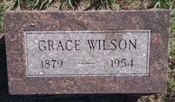
Grace May Kay Wilson
| Birth | : | Feb 1879 Nemaha County, Nebraska, USA |
| Death | : | 1954 Nebraska, USA |
| Burial | : | Evergreen Cemetery, Loup City, Sherman County, USA |
| Coordinate | : | 41.2997017, -98.9852982 |
| Description | : | Married 1907 Sherman Co, NE, Sherman Louis Wilson (b. Oct 30 1879, living in CO 1930) In the 1920 and 1930 Censuses, she was in the Hastings State Hospital, Adams Co, NE Other children: Charles (b.~1908 NE) Wilber (b.~1911 NE) George (b.~1913 NE) |
frequently asked questions (FAQ):
-
Where is Grace May Kay Wilson's memorial?
Grace May Kay Wilson's memorial is located at: Evergreen Cemetery, Loup City, Sherman County, USA.
-
When did Grace May Kay Wilson death?
Grace May Kay Wilson death on 1954 in Nebraska, USA
-
Where are the coordinates of the Grace May Kay Wilson's memorial?
Latitude: 41.2997017
Longitude: -98.9852982
Family Members:
Parent

Siblings
Children
Flowers:


Nearby Cemetories:
1. Evergreen Cemetery
Loup City, Sherman County, USA
Coordinate: 41.2997017, -98.9852982
2. Saint Josaphats Cemetery
Loup City, Sherman County, USA
Coordinate: 41.3022003, -98.9847031
3. Sunny Slope Cemetery
Loup City, Sherman County, USA
Coordinate: 41.2906000, -99.0267000
4. Cleoria Cemetery
Loup City, Sherman County, USA
Coordinate: 41.2779000, -99.0893500
5. Balsora Cemetery
Sherman County, USA
Coordinate: 41.3782997, -99.0975037
6. Austin Cemetery
Rockville, Sherman County, USA
Coordinate: 41.1880989, -98.8981018
7. Verdurette Cemetery
Sherman County, USA
Coordinate: 41.1697006, -98.9757996
8. Davis Creek Cemetery
Valley County, USA
Coordinate: 41.4219017, -98.9052963
9. Saint Francis Cemetery
Ashton, Sherman County, USA
Coordinate: 41.2438000, -98.7994000
10. Lone Elm Cemetery
Loup City, Sherman County, USA
Coordinate: 41.2921982, -99.1864014
11. Immanuel Lutheran Cemetery
Ashton, Sherman County, USA
Coordinate: 41.2140000, -98.8142000
12. Gray Cemetery
Sherman County, USA
Coordinate: 41.2099991, -99.1567001
13. Arcadia Cemetery
Arcadia, Valley County, USA
Coordinate: 41.4237000, -99.1167000
14. Pleasant Hill Friends Cemetery
Valley County, USA
Coordinate: 41.4230800, -98.8377700
15. Dunkard Cemetery
Arcadia, Valley County, USA
Coordinate: 41.4522000, -99.0769000
16. Union Cemetery
Ashton, Sherman County, USA
Coordinate: 41.2214012, -98.7855988
17. Litchfield Cemetery
Litchfield, Sherman County, USA
Coordinate: 41.1543999, -99.1283035
18. Mount Carmel Cemetery
Howard County, USA
Coordinate: 41.2797012, -98.7328033
19. Salem Evangelical Church Cemetery
Ord, Valley County, USA
Coordinate: 41.4902992, -98.9244003
20. Lewis Burial Plat
Litchfield, Sherman County, USA
Coordinate: 41.1383000, -99.1484000
21. Trinity Lutheran Church Cemetery
Hazard, Sherman County, USA
Coordinate: 41.0913000, -99.0052000
22. Lee Park Cemetery
Custer County, USA
Coordinate: 41.4025002, -99.2307968
23. Lee Park Catholic Cemetery
Westerville, Custer County, USA
Coordinate: 41.4091988, -99.2311020
24. Saint Marys Cemetery
Rockville, Sherman County, USA
Coordinate: 41.1202000, -98.8255000