
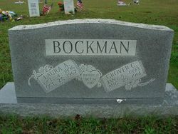
Grover Cleveland “Cleve” Bockman
| Birth | : | 8 Jan 1893 Oregon County, Missouri, USA |
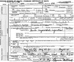
| Death | : | 25 Aug 1961 Mountain View, Howell County, Missouri, USA |
| Burial | : | Milton Cemetery, Portsmouth, Portsmouth Unitary Authority, England |
| Coordinate | : | 50.7988700, -1.0608030 |
| Plot | : | E Cen Sec |
| Description | : | Son of Thomas Bockman and Missouri (Hahn) Bockman. Married Laura Williams 14/Oct/1917 at Greer, MO. Grocer. Per MO Death certificate #61-032672, burial 27/Aug/1961. |
frequently asked questions (FAQ):
-
Where is Grover Cleveland “Cleve” Bockman's memorial?
Grover Cleveland “Cleve” Bockman's memorial is located at: Milton Cemetery, Portsmouth, Portsmouth Unitary Authority, England.
-
When did Grover Cleveland “Cleve” Bockman death?
Grover Cleveland “Cleve” Bockman death on 25 Aug 1961 in Mountain View, Howell County, Missouri, USA
-
Where are the coordinates of the Grover Cleveland “Cleve” Bockman's memorial?
Latitude: 50.7988700
Longitude: -1.0608030
Family Members:
Parent
Spouse

Siblings
Children

Flowers:


Nearby Cemetories:
1. Milton Cemetery
Portsmouth, Portsmouth Unitary Authority, England
Coordinate: 50.7988700, -1.0608030
2. St James Churchyard
Eastney, Portsmouth Unitary Authority, England
Coordinate: 50.7940650, -1.0581150
3. Kingston Cemetery
Portsmouth, Portsmouth Unitary Authority, England
Coordinate: 50.8031440, -1.0683260
4. St. Mary's Churchyard
Portsea, Portsmouth Unitary Authority, England
Coordinate: 50.8035350, -1.0763490
5. Old Jewish Cemetery
Portsmouth, Portsmouth Unitary Authority, England
Coordinate: 50.7887000, -1.0738800
6. Highland Road Cemetery
Portsmouth, Portsmouth Unitary Authority, England
Coordinate: 50.7860500, -1.0671790
7. Mile End Cemetery
Portsea, Portsmouth Unitary Authority, England
Coordinate: 50.8108900, -1.0876400
8. HMS Victoria Monument
Portsmouth, Portsmouth Unitary Authority, England
Coordinate: 50.7997200, -1.0950800
9. Portsmouth Unitarian Church
Portsmouth, Portsmouth Unitary Authority, England
Coordinate: 50.7915640, -1.1011840
10. Portsmouth Naval Memorial
Portsmouth, Portsmouth Unitary Authority, England
Coordinate: 50.7824440, -1.0957720
11. Portsmouth Cathedral Churchyard
Portsmouth, Portsmouth Unitary Authority, England
Coordinate: 50.7904650, -1.1043720
12. Royal Garrison Church Churchyard
Plymouth, Plymouth Unitary Authority, England
Coordinate: 50.7889690, -1.1039650
13. Royal Garrison Churchyard
Portsmouth, Portsmouth Unitary Authority, England
Coordinate: 50.7890180, -1.1040520
14. HMS Victory Ship
Portsmouth, Portsmouth Unitary Authority, England
Coordinate: 50.8017290, -1.1095590
15. Holy Trinity Churchyard
Gosport, Gosport Borough, England
Coordinate: 50.7930600, -1.1207620
16. St Peter and St Paul Churchyard
Wymering, Portsmouth Unitary Authority, England
Coordinate: 50.8457490, -1.0777170
17. St John the Evangelist Churchyard
Gosport, Gosport Borough, England
Coordinate: 50.7995600, -1.1397800
18. St. Mary's Churchyard
Portchester, Fareham Borough, England
Coordinate: 50.8366280, -1.1134270
19. Clayhall Naval Cemetery
Gosport, Gosport Borough, England
Coordinate: 50.7833862, -1.1373420
20. Turkish Naval Cemetery
Gosport, Gosport Borough, England
Coordinate: 50.7840710, -1.1383980
21. St Mary the Virgin Churchyard
South Hayling, Havant Borough, England
Coordinate: 50.7954750, -0.9768230
22. St. Andrew's Churchyard
Farlington, Portsmouth Unitary Authority, England
Coordinate: 50.8477200, -1.0274510
23. Roman Grove Cemetery
Portchester, Fareham Borough, England
Coordinate: 50.8384600, -1.1206200
24. St. Mark's Churchyard
Alverstoke, Gosport Borough, England
Coordinate: 50.7826800, -1.1436100