

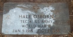
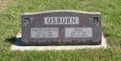
Hale Osborn
| Birth | : | 5 Jan 1918 Battle Creek, Madison County, Nebraska, USA |
| Death | : | 8 Oct 1988 Ord, Valley County, Nebraska, USA |
| Burial | : | Zion Congregational Cemetery, Treynor, Pottawattamie County, USA |
| Coordinate | : | 41.2325090, -95.6079200 |
| Plot | : | Block 7, Lot 60 |
| Inscription | : | † HALE OSBORN TEC 4 US ARMY WORLD WAR II JAN 5 1918 OCT 8 1988 |
frequently asked questions (FAQ):
-
Where is Hale Osborn's memorial?
Hale Osborn's memorial is located at: Zion Congregational Cemetery, Treynor, Pottawattamie County, USA.
-
When did Hale Osborn death?
Hale Osborn death on 8 Oct 1988 in Ord, Valley County, Nebraska, USA
-
Where are the coordinates of the Hale Osborn's memorial?
Latitude: 41.2325090
Longitude: -95.6079200
Family Members:
Parent

Spouse
Siblings
Children

Flowers:


Nearby Cemetories:
1. Zion Congregational Cemetery
Treynor, Pottawattamie County, USA
Coordinate: 41.2325090, -95.6079200
2. Saint Paul Lutheran Cemetery
Treynor, Pottawattamie County, USA
Coordinate: 41.2322000, -95.6380000
3. Fairview Pioneer Cemetery
Treynor, Pottawattamie County, USA
Coordinate: 41.2812843, -95.5555267
4. Hardin Township Cemetery
McClelland, Pottawattamie County, USA
Coordinate: 41.2949982, -95.6513977
5. Keg Creek Township Cemetery
Treynor, Pottawattamie County, USA
Coordinate: 41.1913986, -95.6893997
6. Pottawattamie County Home Cemetery
McClelland, Pottawattamie County, USA
Coordinate: 41.3269400, -95.6691738
7. Zion Cemetery
Pottawattamie County, USA
Coordinate: 41.1778000, -95.7272000
8. Mineola Cemetery
Mineola, Mills County, USA
Coordinate: 41.1391130, -95.6941800
9. Saint Pauls Evangelical Country Church Cemetery
Dumfries, Pottawattamie County, USA
Coordinate: 41.1748352, -95.7492371
10. Stoker-Graybill Cemetery
Council Bluffs, Pottawattamie County, USA
Coordinate: 41.2532620, -95.7751770
11. Old Town Cemetery
Macedonia, Pottawattamie County, USA
Coordinate: 41.2030983, -95.4421997
12. Silver City Cemetery
Silver City, Mills County, USA
Coordinate: 41.1042442, -95.6380005
13. Belknap Cemetery
Oakland, Pottawattamie County, USA
Coordinate: 41.2924995, -95.4424973
14. Downsville Cemetery
Pottawattamie County, USA
Coordinate: 41.3502998, -95.7039032
15. Saint Boniface Catholic Cemetery
Mills County, USA
Coordinate: 41.1419000, -95.7467100
16. Salem Lutheran Church Cemetery
Glenwood, Mills County, USA
Coordinate: 41.1556015, -95.7617035
17. Lewis Township Cemetery
Council Bluffs, Pottawattamie County, USA
Coordinate: 41.2117004, -95.7938995
18. Jones - Williams Cemetery
Pottawattamie County, USA
Coordinate: 41.3761000, -95.5846000
19. Macedonia Cemetery
Macedonia, Pottawattamie County, USA
Coordinate: 41.1921997, -95.4167023
20. Saint Columbanus Cemetery
Weston, Pottawattamie County, USA
Coordinate: 41.3429440, -95.7435260
21. Saylers Farm Cemetery
Henderson, Mills County, USA
Coordinate: 41.1083300, -95.4919440
22. Big Grove Cemetery
Pottawattamie County, USA
Coordinate: 41.3088420, -95.4322120
23. Carson Cemetery
Carson, Pottawattamie County, USA
Coordinate: 41.2392006, -95.4044037
24. Wesley Chapel Cemetery
Henderson, Mills County, USA
Coordinate: 41.1019249, -95.4987793