
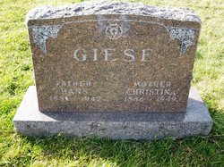
Hans Giese
| Birth | : | 16 Mar 1881 Germany |
| Death | : | 12 Oct 1942 Ogden, Boone County, Iowa, USA |
| Burial | : | Greenwood Cemetery, Aurelius, Ingham County, USA |
| Coordinate | : | 42.5138893, -84.5233307 |
frequently asked questions (FAQ):
-
Where is Hans Giese's memorial?
Hans Giese's memorial is located at: Greenwood Cemetery, Aurelius, Ingham County, USA.
-
When did Hans Giese death?
Hans Giese death on 12 Oct 1942 in Ogden, Boone County, Iowa, USA
-
Where are the coordinates of the Hans Giese's memorial?
Latitude: 42.5138893
Longitude: -84.5233307
Family Members:
Spouse

Children

Flowers:


Nearby Cemetories:
1. Greenwood Cemetery
Aurelius, Ingham County, USA
Coordinate: 42.5138893, -84.5233307
2. Rolfe Cemetery
Mason, Ingham County, USA
Coordinate: 42.5243988, -84.4569016
3. Fowler Cemetery
Aurelius, Ingham County, USA
Coordinate: 42.5400367, -84.5822004
4. Plains Cemetery
Aurelius, Ingham County, USA
Coordinate: 42.5096200, -84.5944480
5. Lane Cemetery
Onondaga, Ingham County, USA
Coordinate: 42.4505600, -84.5358300
6. North Aurelius Cemetery
Aurelius Township, Ingham County, USA
Coordinate: 42.5818420, -84.5388130
7. Bunker Hill Cemetery
Eaton Rapids, Eaton County, USA
Coordinate: 42.5534280, -84.6042970
8. Eden Cemetery
Mason, Ingham County, USA
Coordinate: 42.5210991, -84.4191971
9. Onondaga Cemetery
Onondaga, Ingham County, USA
Coordinate: 42.4445877, -84.5699387
10. First United Methodist Church of Mason Columbarium
Mason, Ingham County, USA
Coordinate: 42.5796620, -84.4414330
11. Woodlawn Cemetery
Leslie, Ingham County, USA
Coordinate: 42.4570274, -84.4298935
12. Maple Grove Cemetery
Mason, Ingham County, USA
Coordinate: 42.5856018, -84.4458008
13. Munger Cemetery
Eaton Rapids, Eaton County, USA
Coordinate: 42.5746994, -84.6213989
14. Walker Cemetery
Rives Junction, Jackson County, USA
Coordinate: 42.4218712, -84.4820557
15. Markham Cemetery
Holt, Ingham County, USA
Coordinate: 42.6035995, -84.5819016
16. Rosehill Cemetery
Eaton Rapids, Eaton County, USA
Coordinate: 42.5003014, -84.6635971
17. Oakwood Cemetery
Eaton Rapids, Eaton County, USA
Coordinate: 42.4947014, -84.6659012
18. Hawley Cemetery
Mason, Ingham County, USA
Coordinate: 42.5508003, -84.3792038
19. Bentley Cemetery
Eaton Rapids, Eaton County, USA
Coordinate: 42.5456009, -84.6761017
20. Stewart Cemetery (Defunct)
Tompkins, Jackson County, USA
Coordinate: 42.3944321, -84.5210876
21. Rives Township Memorial Cemetery
Rives Junction, Jackson County, USA
Coordinate: 42.3993660, -84.4731100
22. Griffith Cemetery
Springport, Jackson County, USA
Coordinate: 42.4150620, -84.6215515
23. Felt Plains Cemetery
Leslie, Ingham County, USA
Coordinate: 42.4874992, -84.3585968
24. Brown Cemetery
Tompkins, Jackson County, USA
Coordinate: 42.3927765, -84.5833359