
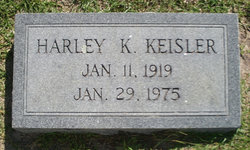
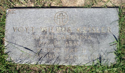
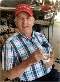
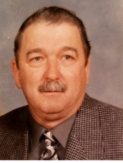
Harley K. Keisler
| Birth | : | 11 Jan 1919 |
| Death | : | 29 Jan 1975 |
| Burial | : | Christ Church Churchyard, Accrington, Hyndburn Borough, England |
| Coordinate | : | 53.7478560, -2.3605820 |
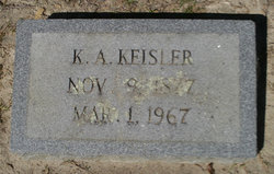
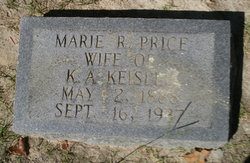
| Description | : | Funeral services for Harley Keisler will be held at 4 p.m. tomorrow at St. Paul's Lutheran Church. Mr. Keisler, 56, died yesterday in a fire at his home. Pallbearers will be Curtis Reynolds, John Cogburn, H. E. Shealy, Greever Sease, D. G. Long and Wayne Rawl. Born in Lexington County, he was a son of the late K. A. and Marie Price Keisler. He was a farmer and a member of St. Paul's Lutheran Church. Surviving are two daughters, Mrs. Patty Gunter and Mrs. Ann Sharpe of Gilbert; three sons, Bobby G., H. B. and David Keisler of Gilbert and... Read More |
frequently asked questions (FAQ):
-
Where is Harley K. Keisler's memorial?
Harley K. Keisler's memorial is located at: Christ Church Churchyard, Accrington, Hyndburn Borough, England.
-
When did Harley K. Keisler death?
Harley K. Keisler death on 29 Jan 1975 in
-
Where are the coordinates of the Harley K. Keisler's memorial?
Latitude: 53.7478560
Longitude: -2.3605820
Family Members:
Parent
Spouse
Siblings
Children
Flowers:


Nearby Cemetories:
1. Christ Church Churchyard
Accrington, Hyndburn Borough, England
Coordinate: 53.7478560, -2.3605820
2. St. James' Parish Church
Accrington, Hyndburn Borough, England
Coordinate: 53.7519900, -2.3652600
3. St. John the Baptist Churchyard
Baxenden, Hyndburn Borough, England
Coordinate: 53.7346500, -2.3470230
4. Accrington Cemetery and Crematorium
Accrington, Hyndburn Borough, England
Coordinate: 53.7623787, -2.3508649
5. Church and Clayton-le-Moors Cemetery
Accrington, Hyndburn Borough, England
Coordinate: 53.7630200, -2.3804820
6. St James Churchyard
Church, Hyndburn Borough, England
Coordinate: 53.7574640, -2.3942660
7. New Lane Baptist Chapel Chapelyard
Oswaldwistle, Hyndburn Borough, England
Coordinate: 53.7381100, -2.4049500
8. Immanuel Churchyard
Oswaldwistle, Hyndburn Borough, England
Coordinate: 53.7358300, -2.4056200
9. Barnes Square Weslyan Methodist Churchyard
Clayton-le-Moors, Hyndburn Borough, England
Coordinate: 53.7744350, -2.3853800
10. All Saints Churchyard
Clayton-le-Moors, Hyndburn Borough, England
Coordinate: 53.7738520, -2.3881690
11. St Marys Burial Ground
Clayton-le-Moors, Hyndburn Borough, England
Coordinate: 53.7792778, -2.3705871
12. St Margaret Churchyard
Hapton, Burnley Borough, England
Coordinate: 53.7802400, -2.3169230
13. Rehoboth Chapel
Goodshaw, Rossendale Borough, England
Coordinate: 53.7355870, -2.2914730
14. Great Harwood Cemetery
Great Harwood, Hyndburn Borough, England
Coordinate: 53.7796190, -2.4091680
15. Our Lady and Saint Hubert
Great Harwood, Hyndburn Borough, England
Coordinate: 53.7851070, -2.4009760
16. St James Churchyard
Haslingden, Rossendale Borough, England
Coordinate: 53.7084000, -2.3259550
17. St James Church
Altham, Hyndburn Borough, England
Coordinate: 53.7928940, -2.3465250
18. Providence Free United Methodist Graveyard
Crawshawbooth, Rossendale Borough, England
Coordinate: 53.7442070, -2.2825700
19. King Street Methodist Chapel Chapelyard
Haslingden, Rossendale Borough, England
Coordinate: 53.7066710, -2.3231330
20. Haslingden Grane Methodist Chapel Cemetery
Haslingden, Rossendale Borough, England
Coordinate: 53.7016300, -2.3728190
21. Ebenezer Baptist Chapel Chapelyard
Haslingden, Rossendale Borough, England
Coordinate: 53.7053960, -2.3230070
22. St. Mary and All Saints Churchyard
Goodshaw, Rossendale Borough, England
Coordinate: 53.7315270, -2.2828940
23. Crawshawbooth Quaker Burial Ground
Crawshawbooth, Rossendale Borough, England
Coordinate: 53.7242420, -2.2879400
24. Goodshaw Particular Baptist Chapel Graveyard
Goodshaw, Rossendale Borough, England
Coordinate: 53.7328210, -2.2815530