
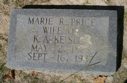
Marie Ruth Price Keisler
| Birth | : | 2 May 1888 Lexington County, South Carolina, USA |
| Death | : | 16 Sep 1937 Gilbert, Lexington County, South Carolina, USA |
| Burial | : | Prospect Hill Cemetery, Omaha, Douglas County, USA |
| Coordinate | : | 41.2780991, -95.9593964 |
| Inscription | : | w/o K.A. Keisler |
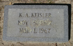
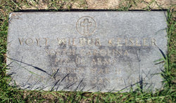
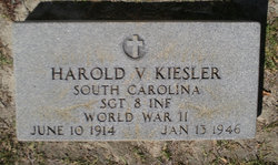
| Description | : | Lexington, Sept. 16 - Mrs. K. A. Keisler, 49, died at her home in the Hollow Creek section of Lexington county, near Gilbert, Thursday afternoon after a short illness. She was a member of St. Paul's Hollow Creek Lutheran church and of the Ladies' Aid society of that church. She took an active interest in all of the activities of the church. She was always ready to lend a helping hand to her many friends to her many friends and neighbors. She is survived by her husband, K. A. Keisler; three sons, Voight Keisler, Harvey Keisler, Harold Keisler, all of... Read More |
frequently asked questions (FAQ):
-
Where is Marie Ruth Price Keisler's memorial?
Marie Ruth Price Keisler's memorial is located at: Prospect Hill Cemetery, Omaha, Douglas County, USA.
-
When did Marie Ruth Price Keisler death?
Marie Ruth Price Keisler death on 16 Sep 1937 in Gilbert, Lexington County, South Carolina, USA
-
Where are the coordinates of the Marie Ruth Price Keisler's memorial?
Latitude: 41.2780991
Longitude: -95.9593964
Family Members:
Parent
Spouse
Siblings
Children
Flowers:


Nearby Cemetories:
1. Prospect Hill Cemetery
Omaha, Douglas County, USA
Coordinate: 41.2780991, -95.9593964
2. Nash Chapel Crypt
Omaha, Douglas County, USA
Coordinate: 41.2665090, -95.9721790
3. First Central Congregational Columbarium
Omaha, Douglas County, USA
Coordinate: 41.2563456, -95.9658365
4. Trinity Cathedral Columbarium
Omaha, Douglas County, USA
Coordinate: 41.2603900, -95.9393660
5. Golden Hill Cemetery
Omaha, Douglas County, USA
Coordinate: 41.3050003, -95.9744034
6. Holy Sepulchre Cemetery
Omaha, Douglas County, USA
Coordinate: 41.2543983, -95.9875031
7. Douglas County Poor Farm Cemetery
Omaha, Douglas County, USA
Coordinate: 41.2437240, -95.9723480
8. Pleasant Hill Jewish Cemetery
Omaha, Douglas County, USA
Coordinate: 41.3185997, -95.9766998
9. Bohemian Cemetery
Omaha, Douglas County, USA
Coordinate: 41.2388992, -95.9955978
10. Springwell Cemetery
Omaha, Douglas County, USA
Coordinate: 41.3114014, -96.0096970
11. Westlawn-Hillcrest Memorial Park
Omaha, Douglas County, USA
Coordinate: 41.2346992, -95.9966965
12. Forest Lawn Memorial Park
Omaha, Douglas County, USA
Coordinate: 41.3272018, -95.9847031
13. Servants of Mary Cemetery
Omaha, Douglas County, USA
Coordinate: 41.3017170, -96.0258260
14. Ak-Sar-Ben Racetrack Grounds
Omaha, Douglas County, USA
Coordinate: 41.2414703, -96.0159607
15. Mormon Pioneer Cemetery
Omaha, Douglas County, USA
Coordinate: 41.3348450, -95.9663720
16. Potter Field
Omaha, Douglas County, USA
Coordinate: 41.3320274, -95.9902878
17. Mount Hope Cemetery
Omaha, Douglas County, USA
Coordinate: 41.3041992, -96.0310974
18. Mount Sinai Cemetery
Omaha, Douglas County, USA
Coordinate: 41.3116989, -96.0314026
19. Calvary Cemetery
Omaha, Douglas County, USA
Coordinate: 41.2364006, -96.0294037
20. Graceland Park Cemetery
Omaha, Douglas County, USA
Coordinate: 41.2113991, -95.9785995
21. Saint Andrews Episcopal Church Columbarium
Omaha, Douglas County, USA
Coordinate: 41.2492500, -96.0427500
22. Evergreen Memorial Park Cemetery
Omaha, Douglas County, USA
Coordinate: 41.2393990, -96.0355988
23. Resurrection Cemetery
Omaha, Douglas County, USA
Coordinate: 41.2344208, -96.0365448
24. Saint Mary's Cemetery
Omaha, Douglas County, USA
Coordinate: 41.2042007, -95.9646988