
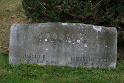
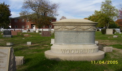
Harold Rollin Woodruff
| Birth | : | 4 Oct 1900 Mount Carmel, New Haven County, Connecticut, USA |
| Death | : | 15 May 1989 Branford, New Haven County, Connecticut, USA |
| Burial | : | St. Peter's Churchyard, Lowick, East Northamptonshire Borough, England |
| Coordinate | : | 52.4116300, -0.5570600 |
| Description | : | Source: Descendants of Mathew Woodruff of Farmington, Connecticut By Susan Emma Woodruff Abbott · 1963 page 562 |
frequently asked questions (FAQ):
-
Where is Harold Rollin Woodruff's memorial?
Harold Rollin Woodruff's memorial is located at: St. Peter's Churchyard, Lowick, East Northamptonshire Borough, England.
-
When did Harold Rollin Woodruff death?
Harold Rollin Woodruff death on 15 May 1989 in Branford, New Haven County, Connecticut, USA
-
Where are the coordinates of the Harold Rollin Woodruff's memorial?
Latitude: 52.4116300
Longitude: -0.5570600
Family Members:
Parent

Spouse

Siblings
Flowers:


Nearby Cemetories:
1. St. Peter's Churchyard
Lowick, East Northamptonshire Borough, England
Coordinate: 52.4116300, -0.5570600
2. St. Nicholas Churchyard
Islip, East Northamptonshire Borough, England
Coordinate: 52.3991300, -0.5513600
3. Thrapston Cemetery
Thrapston, East Northamptonshire Borough, England
Coordinate: 52.4000170, -0.5292640
4. All Saints Church
Sudborough, East Northamptonshire Borough, England
Coordinate: 52.4283980, -0.5782500
5. Aldwincle St Peters Churchyard
Aldwincle, East Northamptonshire Borough, England
Coordinate: 52.4255060, -0.5217460
6. All Saints Churchyard
Aldwincle, East Northamptonshire Borough, England
Coordinate: 52.4222080, -0.5142150
7. St. Nicholas' Churchyard
Twywell, East Northamptonshire Borough, England
Coordinate: 52.3936001, -0.6024166
8. Holy Trinity Church
Denford, East Northamptonshire Borough, England
Coordinate: 52.3787353, -0.5450568
9. St. Mary's Churchyard
Titchmarsh, East Northamptonshire Borough, England
Coordinate: 52.4076080, -0.4998860
10. St. Michael and All Angels Churchyard
Wadenhoe, East Northamptonshire Borough, England
Coordinate: 52.4382400, -0.5176200
11. Station Street Cemetery
Ringstead, East Northamptonshire Borough, England
Coordinate: 52.3654427, -0.5538628
12. Nativity of the Blessed Virgin Mary Churchyard
Ringstead, East Northamptonshire Borough, England
Coordinate: 52.3652660, -0.5533620
13. Station Road Cemetery
Ringsted Kommune, Denmark
Coordinate: 52.3638126, -0.5592430
14. All Saints Churchyard
Great Addington, East Northamptonshire Borough, England
Coordinate: 52.3657660, -0.5937010
15. Brigstock Parish Cemetery
Brigstock, East Northamptonshire Borough, England
Coordinate: 52.4552481, -0.6061781
16. St. James the Apostle Churchyard
Grafton Underwood, Kettering Borough, England
Coordinate: 52.4108323, -0.6449725
17. St. John's Churchyard
Cranford St John, Kettering Borough, England
Coordinate: 52.3840560, -0.6391670
18. St. Andrew's Churchyard
Cranford, Kettering Borough, England
Coordinate: 52.3856700, -0.6438700
19. Raunds Cemetery
Raunds, East Northamptonshire Borough, England
Coordinate: 52.3494100, -0.5467400
20. All Saints Chancel
Barnwell, East Northamptonshire Borough, England
Coordinate: 52.4482400, -0.4594600
21. St. Rumbold Churchyard
Stoke Doyle, East Northamptonshire Borough, England
Coordinate: 52.4678253, -0.4880529
22. St. Mary Churchyard
Benefield, East Northamptonshire Borough, England
Coordinate: 52.4854100, -0.5460660
23. St. Peter's Churchyard
Clopton, East Northamptonshire Borough, England
Coordinate: 52.4077000, -0.4342000
24. St. Laurence Churchyard Stanwick
Stanwick, East Northamptonshire Borough, England
Coordinate: 52.3324970, -0.5628585