
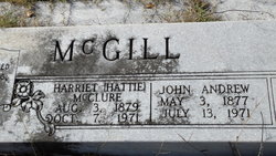

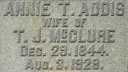
Harriet “Hattie” McClure McGill
| Birth | : | 3 Aug 1879 Anderson County, South Carolina, USA |
| Death | : | 7 Oct 1971 USA |
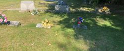
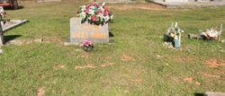
| Burial | : | Jarrell Family Graveyard, Lowgap, Surry County, USA |
| Coordinate | : | 36.5362520, -80.7798310 |
frequently asked questions (FAQ):
-
Where is Harriet “Hattie” McClure McGill's memorial?
Harriet “Hattie” McClure McGill's memorial is located at: Jarrell Family Graveyard, Lowgap, Surry County, USA.
-
When did Harriet “Hattie” McClure McGill death?
Harriet “Hattie” McClure McGill death on 7 Oct 1971 in USA
-
Where are the coordinates of the Harriet “Hattie” McClure McGill's memorial?
Latitude: 36.5362520
Longitude: -80.7798310
Family Members:
Parent
Spouse

Siblings

Flowers:


Nearby Cemetories:
1. Jarrell Family Graveyard
Lowgap, Surry County, USA
Coordinate: 36.5362520, -80.7798310
2. Ivy Green Baptist Church Cemetery
Crooked Oak, Surry County, USA
Coordinate: 36.5381927, -80.7771683
3. Holder Cemetery
Lowgap, Surry County, USA
Coordinate: 36.5364670, -80.7875720
4. Blue Ridge Baptist Church Cemetery
Crooked Oak, Surry County, USA
Coordinate: 36.5490440, -80.7727400
5. Low Family Cemetery
Lowgap, Surry County, USA
Coordinate: 36.5461430, -80.7985910
6. Zion Hill Primitive Baptist Church Cemetery
Crooked Oak, Surry County, USA
Coordinate: 36.5313339, -80.7572250
7. Dillard Family Cemetery
Lowgap, Surry County, USA
Coordinate: 36.5500298, -80.8002243
8. Golding Family Cemetery
Mount Airy, Surry County, USA
Coordinate: 36.5326670, -80.7528330
9. Round Peak Primitive Baptist Church Cemetery
Round Peak, Surry County, USA
Coordinate: 36.5145264, -80.7861633
10. Jarrell Family Cemetery
Lowgap, Surry County, USA
Coordinate: 36.5427860, -80.8103660
11. Phillip Haywood McBride Family Cemetery
Lowgap, Surry County, USA
Coordinate: 36.5602950, -80.7678630
12. Stewart Cemetery
Lambsburg, Carroll County, USA
Coordinate: 36.5681860, -80.7855490
13. Montgomery Cemetery
Surry County, USA
Coordinate: 36.5439722, -80.8204722
14. Holly Grove Baptist Church Cemetery
Lambsburg, Carroll County, USA
Coordinate: 36.5712840, -80.7810790
15. Johnson Puckett Cemetery
Mount Airy, Surry County, USA
Coordinate: 36.5306740, -80.7362830
16. Furbee Cemetery
Wetzel County, USA
Coordinate: 36.5363984, -80.7316687
17. Edwards-Upchurch Cemetery
Lambsburg, Carroll County, USA
Coordinate: 36.5750140, -80.7788060
18. Snow Cemetery
Mount Airy, Surry County, USA
Coordinate: 36.5422500, -80.7299170
19. Fellowship Tabernacle Cemetery
Lambsburg, Carroll County, USA
Coordinate: 36.5769680, -80.7723510
20. Payne Cemetery
Lowgap, Surry County, USA
Coordinate: 36.4947220, -80.7928060
21. Barker Graveyard
Lowgap, Surry County, USA
Coordinate: 36.5295540, -80.8340600
22. W H Stantliff Cemetery
Lambsburg, Carroll County, USA
Coordinate: 36.5807290, -80.7794670
23. Moore Family Cemetery
Mount Airy, Surry County, USA
Coordinate: 36.4919910, -80.7741450
24. Chestnut Grove Primitive Baptist Church Cemetery
Lambsburg, Carroll County, USA
Coordinate: 36.5800740, -80.7686640