Harry Alfonso Driscoll
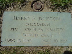
| Birth | : | 18 Dec 1893 Lead Mine, Lafayette County, Wisconsin, USA |
| Death | : | 20 May 1957 Milwaukee County, Wisconsin, USA |
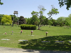
| Burial | : | Sunset Ridge Memorial Park, Kenosha, Kenosha County, USA |
| Coordinate | : | 42.6007996, -87.8833008 |
| Plot | : | Section E, Lot 112, Space 2 |
| Inscription | : | Wisconsin PFC CO H 53 Infantry World War I |
| Description | : | Harry Driscoll, 63, 3814 61st St., died Monday morning at the Veterans Administration hospital at Wood*, Wis., following a long illness. The son of the late Mr. and Mrs. John Driscoll, he was born Dec. 18, 1893, in Lead Mine, Wis. He received his early education in Benton, Wis., and came to Kenosha in 1919. On Nov. 5, 1917, in Platteville, Wis., he married Miss Olga Briener. He was a member of the First Unitarian Society of Kenosha and the Junker-Ball Post 1865, VFW, of which he was a past commander. For the past 30... Read More |
frequently asked questions (FAQ):
-
Where is Harry Alfonso Driscoll's memorial?
Harry Alfonso Driscoll's memorial is located at: Sunset Ridge Memorial Park, Kenosha, Kenosha County, USA.
-
When did Harry Alfonso Driscoll death?
Harry Alfonso Driscoll death on 20 May 1957 in Milwaukee County, Wisconsin, USA
-
Where are the coordinates of the Harry Alfonso Driscoll's memorial?
Latitude: 42.6007996
Longitude: -87.8833008
Family Members:
Parent
Spouse
Siblings
Flowers:
Nearby Cemetories:
1. Sunset Ridge Memorial Park
Kenosha, Kenosha County, USA
Coordinate: 42.6007996, -87.8833008
2. Saint Casimir Cemetery
Kenosha, Kenosha County, USA
Coordinate: 42.6060982, -87.8641968
3. Oakwood Cemetery
Somers, Kenosha County, USA
Coordinate: 42.6394005, -87.8743973
4. Vale Cemetery
Kenosha, Kenosha County, USA
Coordinate: 42.5675011, -87.9241638
5. Colonel Howe Estate Cemetery
Kenosha, Kenosha County, USA
Coordinate: 42.6015010, -87.8222180
6. Saint George Cemetery
Kenosha, Kenosha County, USA
Coordinate: 42.6147003, -87.8238983
7. Saint Matthews Episcopal Church Columbarium
Kenosha, Kenosha County, USA
Coordinate: 42.5819290, -87.8215848
8. B'nai Zedek Cemetery
Kenosha, Kenosha County, USA
Coordinate: 42.6255188, -87.8248978
9. Green Ridge Cemetery
Kenosha, Kenosha County, USA
Coordinate: 42.5722008, -87.8197021
10. Saint James Cemetery
Kenosha, Kenosha County, USA
Coordinate: 42.5696000, -87.8195100
11. Kenosha County Cemetery
Pleasant Prairie, Kenosha County, USA
Coordinate: 42.5483284, -87.9130630
12. Old Saint Marks Cemetery
Kenosha, Kenosha County, USA
Coordinate: 42.5630600, -87.8208300
13. Saint John Chrysostomos Greek Orthodox Monastery C
Pleasant Prairie, Kenosha County, USA
Coordinate: 42.5394300, -87.8653200
14. All Saints Cemetery
Pleasant Prairie, Kenosha County, USA
Coordinate: 42.5336800, -87.8504300
15. Good Shepherd Mausoleum
Pleasant Prairie, Kenosha County, USA
Coordinate: 42.5209200, -87.8602200
16. North Bristol Cemetery
Bristol, Kenosha County, USA
Coordinate: 42.5681000, -87.9918976
17. Bristol-Paris Cemetery
Paris, Kenosha County, USA
Coordinate: 42.5830700, -88.0015100
18. Paris Lutheran Cemetery
Paris, Kenosha County, USA
Coordinate: 42.6549350, -87.9805540
19. South Bristol Cemetery
Bristol, Kenosha County, USA
Coordinate: 42.5317001, -87.9708023
20. Sylvania Cemetery
Sylvania, Racine County, USA
Coordinate: 42.6819600, -87.9538400
21. Parker Family Cemetery
Sturtevant, Racine County, USA
Coordinate: 42.6973000, -87.8848400
22. Spring Brook Cemetery
Pleasant Prairie, Kenosha County, USA
Coordinate: 42.5028000, -87.8918991
23. East Meadows Cemetery
Racine, Racine County, USA
Coordinate: 42.6975020, -87.8407900
24. Saint Johns Cemetery
Paris, Kenosha County, USA
Coordinate: 42.6340866, -88.0154266

