
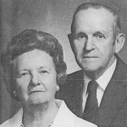


Harry LeRoy McCullough
| Birth | : | 29 Oct 1903 Dayton Township, Iowa County, Iowa, USA |
| Death | : | 7 Jun 1984 Iowa City, Johnson County, Iowa, USA |
| Burial | : | Fairview Cemetery, Smith Center, Smith County, USA |
| Coordinate | : | 39.7966995, -98.7881012 |
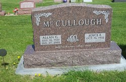
| Description | : | The McCullough Farm located in Iowa County, IA has been owned by one family for 100 years and is now classified a Century Farm. It was originally purchased from the government in 1853 by David McCullough of Tucarwas Co., OH. Five generations have farmed it. I. David McCullough and 2nd wife, Agnes Bell LeeperII. George B. & Alice (Weaver) McCulloughIII. Harry & Edith E. (Giner) McCulloughIV. Allen G. & Joyce (Worrell) McCulloughV. Mark McCullough Harry & Edith McCullough built a home on the family farm and continued to live on the home place until 1955 when they moved to Deep... Read More |
frequently asked questions (FAQ):
-
Where is Harry LeRoy McCullough's memorial?
Harry LeRoy McCullough's memorial is located at: Fairview Cemetery, Smith Center, Smith County, USA.
-
When did Harry LeRoy McCullough death?
Harry LeRoy McCullough death on 7 Jun 1984 in Iowa City, Johnson County, Iowa, USA
-
Where are the coordinates of the Harry LeRoy McCullough's memorial?
Latitude: 39.7966995
Longitude: -98.7881012
Family Members:
Parent
Spouse

Siblings
Children

Flowers:


Nearby Cemetories:
1. Fairview Cemetery
Smith Center, Smith County, USA
Coordinate: 39.7966995, -98.7881012
2. Pleasant View Cemetery
Athol, Smith County, USA
Coordinate: 39.7859000, -98.8982000
3. Meade Cemetery
Reamsville, Smith County, USA
Coordinate: 39.8680992, -98.8839035
4. Saint John Lutheran Cemetery
Athol, Smith County, USA
Coordinate: 39.7269900, -98.8971600
5. Zion Cemetery
Athol, Smith County, USA
Coordinate: 39.8434100, -98.9171700
6. William Nelson Gravesite
Athol, Smith County, USA
Coordinate: 39.8866080, -98.8708130
7. Christ Cemetery
Gaylord, Smith County, USA
Coordinate: 39.6988100, -98.8556700
8. Custer Cemetery
Bellaire, Smith County, USA
Coordinate: 39.7350115, -98.6545141
9. Spring Vale Cemetery
Washington Township, Smith County, USA
Coordinate: 39.9154700, -98.7424900
10. Cedar Hill Cemetery
Cora, Smith County, USA
Coordinate: 39.8863200, -98.6550000
11. Crystal Plains Cemetery
Smith Center, Smith County, USA
Coordinate: 39.6909714, -98.6730270
12. Oak Hill Cemetery
Lebanon, Smith County, USA
Coordinate: 39.8437010, -98.6186200
13. Gaylord Cemetery
Gaylord, Smith County, USA
Coordinate: 39.6598300, -98.8416700
14. Parse Homestead Cemetery
Bellaire, Smith County, USA
Coordinate: 39.7269800, -98.6245300
15. Price Cemetery
Oak Township, Smith County, USA
Coordinate: 39.7986860, -98.5993060
16. Eminence Cemetery
Thornburg, Smith County, USA
Coordinate: 39.9432983, -98.8005981
17. Reamsville Methodist Church Cemetery
Reamsville, Smith County, USA
Coordinate: 39.9299500, -98.8693970
18. Reamsville Cemetery
Reamsville, Smith County, USA
Coordinate: 39.9441500, -98.8593500
19. Bell Cemetery
Smith Center, Smith County, USA
Coordinate: 39.6477700, -98.7102200
20. Cedar Cemetery
Cedar, Smith County, USA
Coordinate: 39.6685982, -98.9310989
21. Old Harlan Cemetery
Harlan, Smith County, USA
Coordinate: 39.6153520, -98.7632390
22. Pleasant Hill Cemetery
Reamsville, Smith County, USA
Coordinate: 39.9510994, -98.9175034
23. Sweet Home Cemetery
Lebanon, Smith County, USA
Coordinate: 39.7854830, -98.5465380
24. Womer Cemetery
Womer, Smith County, USA
Coordinate: 39.9736400, -98.7110800