
| Birth | : | 26 Jun 1911 Allerton, Wayne County, Iowa, USA |
| Death | : | 1 Mar 1988 Corydon, Wayne County, Iowa, USA |
| Burial | : | St. Michael and All Angels Churchyard, Tatenhill, East Staffordshire Borough, England |
| Coordinate | : | 52.7958170, -1.6968150 |
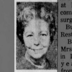
| Description | : | Funeral services for Hazel Whiteley, 76, were held March 4 at 1:30 p.m. from the Randolph Funeral Home, Corydon, with the Rev. James Ford officiating. Organ selections "Whispering Hope" and "In The Garden" were played by Marilyn Jackson. The pallbearers were Brad Wilson, Ted Wilson, John Wilson, Ann Wilson, Tracey Whiteley, Todd Whiteley, Brian New and Russ Danielsen. Burial was in the Corydon Cemetery. There was a memorial to the Wayne County Hospital or the Eden Garden Club. Hazel Knapp Whiteley was born in Allerton June 26, 1911 and was the daughter of Minnie Jones... Read More |
frequently asked questions (FAQ):
-
Where is Hazel A Knapp Whiteley's memorial?
Hazel A Knapp Whiteley's memorial is located at: St. Michael and All Angels Churchyard, Tatenhill, East Staffordshire Borough, England.
-
When did Hazel A Knapp Whiteley death?
Hazel A Knapp Whiteley death on 1 Mar 1988 in Corydon, Wayne County, Iowa, USA
-
Where are the coordinates of the Hazel A Knapp Whiteley's memorial?
Latitude: 52.7958170
Longitude: -1.6968150
Family Members:
Parent

Spouse
Siblings
Flowers:


Nearby Cemetories:
1. St. Michael and All Angels Churchyard
Tatenhill, East Staffordshire Borough, England
Coordinate: 52.7958170, -1.6968150
2. Saint Saviour's Cemetery
Burton upon Trent, East Staffordshire Borough, England
Coordinate: 52.7892907, -1.6668628
3. St. Mary's Churchyard, Dunstall
Tatenhill, East Staffordshire Borough, England
Coordinate: 52.7809957, -1.7236464
4. All Saints Churchyard
Rangemore, East Staffordshire Borough, England
Coordinate: 52.8040800, -1.7337000
5. Holy Trinity Churchyard
Anslow, East Staffordshire Borough, England
Coordinate: 52.8216926, -1.7079807
6. St. James' Churchyard
Barton-under-Needwood, East Staffordshire Borough, England
Coordinate: 52.7641321, -1.7228176
7. St Laurence Churchyard
Walton-on-Trent, South Derbyshire District, England
Coordinate: 52.7613386, -1.6819775
8. St Modwen Churchyard
Burton upon Trent, East Staffordshire Borough, England
Coordinate: 52.8013990, -1.6291340
9. Garden of Remembrance
Burton upon Trent, East Staffordshire Borough, England
Coordinate: 52.8023045, -1.6283625
10. Saint John the Divine Churchyard
Horninglow, East Staffordshire Borough, England
Coordinate: 52.8237520, -1.6426170
11. St. Peter's Parish Churchyard
Stapenhill, East Staffordshire Borough, England
Coordinate: 52.7960899, -1.6230323
12. Stapenhill Cemetery
Burton upon Trent, East Staffordshire Borough, England
Coordinate: 52.8026310, -1.6208900
13. Newchurch, Christchurch-in-Needwood
Hoar Cross, East Staffordshire Borough, England
Coordinate: 52.8083859, -1.7811304
14. RAF Fauld
Hanbury, East Staffordshire Borough, England
Coordinate: 52.8474200, -1.7303500
15. Rolleston Cemetery
Rolleston-on-Dove, East Staffordshire Borough, England
Coordinate: 52.8483757, -1.6643849
16. St Mark Churchyard
Winshill, East Staffordshire Borough, England
Coordinate: 52.8082040, -1.6048350
17. St Mary's Churchyard
Stretton, South Staffordshire Borough, England
Coordinate: 52.8336500, -1.6253400
18. St. Mary's Churchyard
Rolleston-on-Dove, East Staffordshire Borough, England
Coordinate: 52.8465144, -1.6519844
19. Catholic Church of Saint Francis of Sales
Yoxall, East Staffordshire Borough, England
Coordinate: 52.7844140, -1.7909000
20. St Mary's Church
Stretton, East Staffordshire Borough, England
Coordinate: 52.8341478, -1.6247215
21. St Leonard's Church
Wychnor, East Staffordshire Borough, England
Coordinate: 52.7420071, -1.7394617
22. St Werburgh's Church
Hanbury, East Staffordshire Borough, England
Coordinate: 52.8485000, -1.7478000
23. St. Peter's Churchyard
Yoxall, East Staffordshire Borough, England
Coordinate: 52.7687960, -1.7915250
24. Priory Church of St. Mary the Virgin
Tutbury, East Staffordshire Borough, England
Coordinate: 52.8590900, -1.6877900