
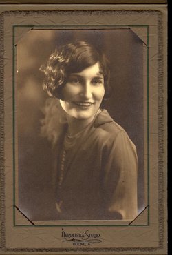
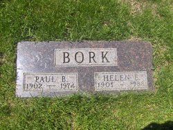
Helen Elizabeth Davisson Bork
| Birth | : | 25 Jun 1901 Woodward, Dallas County, Iowa, USA |
| Death | : | 15 Jun 1988 Ames, Story County, Iowa, USA |
| Burial | : | St. James' Cemetery, Bath, Bath and North East Somerset Unitary Authority, England |
| Coordinate | : | 51.3802000, -2.3722200 |
| Description | : | Helen Elizabeth (Davisson) Bork, 86, 707 Kellogg Avenue, Ames, Iowa, died of congestive heart failure Monday, June 13, 1988, at Riverside Mannor. Funeral services are 10 am Thursday at Stevens Memorial Chapel with the Rev. Gerald Lamotte officiating. Burial will be in Ames Municipal Cemetery. Helen Davisson was born in Boone to Lester and Elizabeth (Burkhart) Davisson. She was raised and educated in Woodward. On June 19, 1930, she married Paul B. Bork, and they moved to Ames. Her memberships included First United Methodist Church. She was also actively involved with the United Methodist Women. Survivors include two... Read More |
frequently asked questions (FAQ):
-
Where is Helen Elizabeth Davisson Bork's memorial?
Helen Elizabeth Davisson Bork's memorial is located at: St. James' Cemetery, Bath, Bath and North East Somerset Unitary Authority, England.
-
When did Helen Elizabeth Davisson Bork death?
Helen Elizabeth Davisson Bork death on 15 Jun 1988 in Ames, Story County, Iowa, USA
-
Where are the coordinates of the Helen Elizabeth Davisson Bork's memorial?
Latitude: 51.3802000
Longitude: -2.3722200
Family Members:
Parent

Spouse

Siblings
Children
Flowers:


Nearby Cemetories:
1. St. James' Cemetery
Bath, Bath and North East Somerset Unitary Authority, England
Coordinate: 51.3802000, -2.3722200
2. St Mary's Chapel, Queens Square
Bath, Bath and North East Somerset Unitary Authority, England
Coordinate: 51.3827790, -2.3649790
3. St Mary Magdalen Chapel
Widcombe, Bath and North East Somerset Unitary Authority, England
Coordinate: 51.3760486, -2.3643405
4. St James Old Burial Ground
Bath, Bath and North East Somerset Unitary Authority, England
Coordinate: 51.3798600, -2.3610100
5. Bath General Hospital Burial Ground
Bath and North East Somerset Unitary Authority, England
Coordinate: 51.3824715, -2.3614742
6. Twerton Cemetery
Twerton, Bath and North East Somerset Unitary Authority, England
Coordinate: 51.3802500, -2.3836220
7. Quaker Meeting House
Bath, Bath and North East Somerset Unitary Authority, England
Coordinate: 51.3823280, -2.3604380
8. St. Mary de Stall Churchyard (Defunct)
Bath, Bath and North East Somerset Unitary Authority, England
Coordinate: 51.3813350, -2.3600353
9. St. Michael's Cemetery
Bath, Bath and North East Somerset Unitary Authority, England
Coordinate: 51.3859700, -2.3814500
10. Ss Michael & Paul Churchyard
Bath, Bath and North East Somerset Unitary Authority, England
Coordinate: 51.3834970, -2.3596980
11. Bath Abbey
Bath, Bath and North East Somerset Unitary Authority, England
Coordinate: 51.3815310, -2.3586640
12. St. Michael's Burial Ground
Bath, Bath and North East Somerset Unitary Authority, England
Coordinate: 51.3838810, -2.3594090
13. Old Orchard Street Catholic Burial Vault
Bath, Bath and North East Somerset Unitary Authority, England
Coordinate: 51.3800370, -2.3579910
14. Locksbrook Cemetery
Lower Weston, Bath and North East Somerset Unitary Authority, England
Coordinate: 51.3845180, -2.3850300
15. Saint Mark's Churchyard
Widcombe, Bath and North East Somerset Unitary Authority, England
Coordinate: 51.3766660, -2.3588010
16. Moravian Burial Ground
Bath, Bath and North East Somerset Unitary Authority, England
Coordinate: 51.3894150, -2.3798150
17. Baptist Burial Ground
Widcombe, Bath and North East Somerset Unitary Authority, England
Coordinate: 51.3764216, -2.3556947
18. Locksbrook St Saviour's Cemetery
Bath and North East Somerset Unitary Authority, England
Coordinate: 51.3867880, -2.3863380
19. St. Swithin Churchyard
Bath, Bath and North East Somerset Unitary Authority, England
Coordinate: 51.3885480, -2.3594500
20. Abbey & St James' Graveyard for the Poor
Widcombe, Bath and North East Somerset Unitary Authority, England
Coordinate: 51.3753550, -2.3545640
21. Old Baptist Burial Ground
Walcot, Bath and North East Somerset Unitary Authority, England
Coordinate: 51.3755070, -2.3544360
22. Walcot Methodist Chapel Burial Ground
Bath, Bath and North East Somerset Unitary Authority, England
Coordinate: 51.3897080, -2.3579610
23. St. Mary's Churchyard
Bathwick, Bath and North East Somerset Unitary Authority, England
Coordinate: 51.3876120, -2.3543540
24. St. John the Baptist Churchyard
Bathwick, Bath and North East Somerset Unitary Authority, England
Coordinate: 51.3886890, -2.3547030