

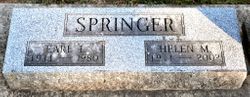

Helen Mae Dann Springer
| Birth | : | 5 Nov 1911 Cedar Falls, Black Hawk County, Iowa, USA |
| Death | : | 1 Oct 2002 Cedar Falls, Black Hawk County, Iowa, USA |
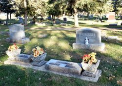
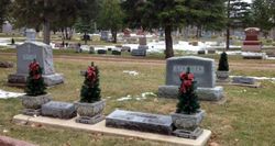
| Burial | : | Donisthorpe Cemetery, Donisthorpe, North West Leicestershire District, England |
| Coordinate | : | 52.7233238, -1.5321259 |
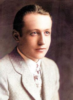
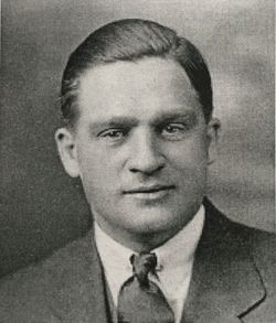
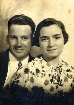
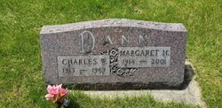
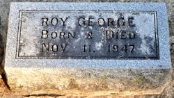
| Description | : | HELEN MAE SPRINGER Helen Mae Springer, 90, of Cedar Falls, formerly of Nashua, passed away October 1, 2002, at Windsor Nursing and Rehabilitation Center in Cedar Falls, Iowa. Helen Dann was born November 5, 1911, in Cedar Falls, the daughter of Frank William and Lillian Mae (Myers) Dann. She was baptized and became a member of the First Baptist Church in Cedar Falls and later joined the United Methodist Church in Nashua. Helen attended Cedar Falls schools where she graduated in 1931. She was married to Gordon James in Galena, Illinois that year. They later divorced. On March... Read More |
frequently asked questions (FAQ):
-
Where is Helen Mae Dann Springer's memorial?
Helen Mae Dann Springer's memorial is located at: Donisthorpe Cemetery, Donisthorpe, North West Leicestershire District, England.
-
When did Helen Mae Dann Springer death?
Helen Mae Dann Springer death on 1 Oct 2002 in Cedar Falls, Black Hawk County, Iowa, USA
-
Where are the coordinates of the Helen Mae Dann Springer's memorial?
Latitude: 52.7233238
Longitude: -1.5321259
Family Members:
Parent
Spouse
Siblings
Children

Flowers:


Nearby Cemetories:
1. Donisthorpe Cemetery
Donisthorpe, North West Leicestershire District, England
Coordinate: 52.7233238, -1.5321259
2. St. John the Evangelist Churchyard
Donisthorpe, North West Leicestershire District, England
Coordinate: 52.7222760, -1.5353450
3. St Tomas Church
Willesley, North West Leicestershire District, England
Coordinate: 52.7292530, -1.4970639
4. St Michael Churchyard
Stretton en le Field, North West Leicestershire District, England
Coordinate: 52.7040970, -1.5516120
5. St. Laurence Courtyard
Measham, North West Leicestershire District, England
Coordinate: 52.7065910, -1.5053110
6. St Peter Churchyard
Netherseal, South Derbyshire District, England
Coordinate: 52.7128960, -1.5741870
7. Measham Cemetery
Measham, North West Leicestershire District, England
Coordinate: 52.7041430, -1.4987930
8. Holy Rood Churchyard
Packington, North West Leicestershire District, England
Coordinate: 52.7268867, -1.4706219
9. Appleby Magna Cemetery
Appleby Magna, North West Leicestershire District, England
Coordinate: 52.6858670, -1.5358910
10. St Matthew Churchyard
Chilcote, North West Leicestershire District, England
Coordinate: 52.6995200, -1.5804990
11. St. Michael and All Angels Churchyard
Appleby Magna, North West Leicestershire District, England
Coordinate: 52.6854410, -1.5353870
12. St Margaret of Antioch Churchyard
Blackfordby, North West Leicestershire District, England
Coordinate: 52.7598200, -1.5115400
13. Ashby De La Zouch Cemetery
Ashby-de-la-Zouch, North West Leicestershire District, England
Coordinate: 52.7460403, -1.4794090
14. Holy Trinity
Ashby-de-la-Zouch, North West Leicestershire District, England
Coordinate: 52.7460010, -1.4757090
15. St. George and St. Mary Churchyard
Church Gresley, South Derbyshire District, England
Coordinate: 52.7597610, -1.5669370
16. St. Helen's Churchyard
Ashby-de-la-Zouch, North West Leicestershire District, England
Coordinate: 52.7473020, -1.4669660
17. Church Gresley Cemetery
Church Gresley, South Derbyshire District, England
Coordinate: 52.7666760, -1.5626180
18. St Mary the Virgin Churchyard
No Man's Heath, North Warwickshire Borough, England
Coordinate: 52.6770470, -1.5722540
19. Saint Peter Churchyard
Swepstone, North West Leicestershire District, England
Coordinate: 52.6912960, -1.4566030
20. All Saints Churchyard
Lullington, South Derbyshire District, England
Coordinate: 52.7135620, -1.6316530
21. St Peter's Church
Hartshorne, South Derbyshire District, England
Coordinate: 52.7840400, -1.5162100
22. Swadlincote Newhall and Stanton Burial Ground
Swadlincote, South Derbyshire District, England
Coordinate: 52.7818200, -1.5683500
23. St. John's Churchyard
Newhall, South Derbyshire District, England
Coordinate: 52.7825310, -1.5685700
24. St Mary Churchyard
Coton in the Elms, South Derbyshire District, England
Coordinate: 52.7358240, -1.6400740