
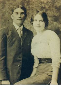
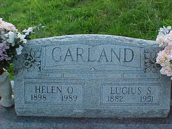

Helen Olean Stallings Garland
| Birth | : | 2 Dec 1898 Spring Gap, Allegany County, Maryland, USA |
| Death | : | 26 Mar 1989 Cumberland, Allegany County, Maryland, USA |
| Burial | : | Wheatley Lane Inghamite Church Churchyard, Wheatley Lane, Pendle Borough, England |
| Coordinate | : | 53.8412800, -2.2457100 |
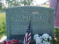
| Description | : | HELEN OLEAN STALLINGS was the daughter of CHARLES "RAYMOND" STALLINGS and LORENA CATHERINE ROOT. She was the wife of LUCIUS SUMMERFIELD GARLAND. They married December 23, 1914 and had 13 children. Cumberland Times-News, Cumberland, MD Monday, March 27, 1989 HELEN O. GARLAND Mrs. Helen Olean Garland, 90, formerly of Utah Avenue, died Sunday, March 26, 1989, at the Allegany County Nursing Home. Born at Spring Gap Dec. 2, 1898, she was the daughter of the late Raymond and Lorena (Root) Stallings. Mrs. Garland was the widow of Lucius S. Garland. She was also preceded in death by three sons. Surviving include five sons, Ralph... Read More |
frequently asked questions (FAQ):
-
Where is Helen Olean Stallings Garland's memorial?
Helen Olean Stallings Garland's memorial is located at: Wheatley Lane Inghamite Church Churchyard, Wheatley Lane, Pendle Borough, England.
-
When did Helen Olean Stallings Garland death?
Helen Olean Stallings Garland death on 26 Mar 1989 in Cumberland, Allegany County, Maryland, USA
-
Where are the coordinates of the Helen Olean Stallings Garland's memorial?
Latitude: 53.8412800
Longitude: -2.2457100
Family Members:
Parent

Spouse

Siblings

Children
Flowers:


Nearby Cemetories:
1. Wheatley Lane Inghamite Church Churchyard
Wheatley Lane, Pendle Borough, England
Coordinate: 53.8412800, -2.2457100
2. All Souls Cemetery
Barrowford, Pendle Borough, England
Coordinate: 53.8462900, -2.2355600
3. Wheatley Lane Methodist Churchyard
Fence, Pendle Borough, England
Coordinate: 53.8341457, -2.2596202
4. St. Anne Churchyard
Fence, Pendle Borough, England
Coordinate: 53.8304372, -2.2679552
5. St. Mary's Churchyard
Newchurch in Pendle, Pendle Borough, England
Coordinate: 53.8504181, -2.2706807
6. St. Thomas Churchyard
Barrowford, Pendle Borough, England
Coordinate: 53.8513900, -2.2196600
7. St. Paul's Churchyard
Nelson, Pendle Borough, England
Coordinate: 53.8289250, -2.2157520
8. Barrowford Cemetery
Nelson, Pendle Borough, England
Coordinate: 53.8521100, -2.2130300
9. Marsden Friends Burial Ground
Marsden, Metropolitan Borough of Kirklees, England
Coordinate: 53.8241910, -2.2197410
10. Nelson Cemetery
Nelson, Pendle Borough, England
Coordinate: 53.8420330, -2.1972230
11. St. John the Evangelist Churchyard
Nelson, Pendle Borough, England
Coordinate: 53.8367000, -2.1977200
12. St John Churchyard
Higham, Pendle Borough, England
Coordinate: 53.8251420, -2.2898120
13. St. James' Churchyard
Briercliffe, Burnley Borough, England
Coordinate: 53.8107700, -2.2031800
14. Haggate Baptist Church Burial Ground
Burnley Borough, England
Coordinate: 53.8145048, -2.1960725
15. Hill Lane Baptist Church Churchyard
Briercliffe, Burnley Borough, England
Coordinate: 53.8161467, -2.1875368
16. Ebenezer Baptist Chapel Chapelyard
Burnley, Burnley Borough, England
Coordinate: 53.7975120, -2.2397260
17. St. Bartholomew Churchyard
Colne, Pendle Borough, England
Coordinate: 53.8570600, -2.1700470
18. West Street Inghamite Chapel Chapelyard
Colne, Pendle Borough, England
Coordinate: 53.8555930, -2.1672140
19. St. Peter's Churchyard
Burnley, Burnley Borough, England
Coordinate: 53.7924450, -2.2394890
20. John Ecroyd's Orchard
Lancaster, City of Lancaster, England
Coordinate: 53.8201990, -2.1697920
21. Twiston Quaker Burial Ground
Clitheroe, Ribble Valley Borough, England
Coordinate: 53.8854210, -2.2838840
22. St. James' Churchyard
Burnley, Burnley Borough, England
Coordinate: 53.7905590, -2.2458280
23. All Saints Churchyard
Habergham Eaves, Burnley Borough, England
Coordinate: 53.7971060, -2.2913770
24. Holy Trinity Churchyard
Burnley, Burnley Borough, England
Coordinate: 53.7898290, -2.2574200