
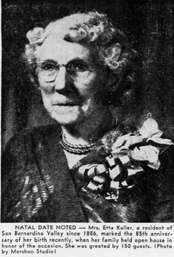
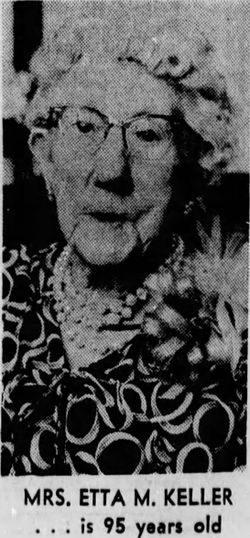

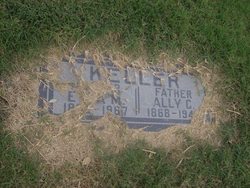
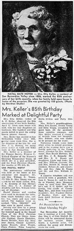
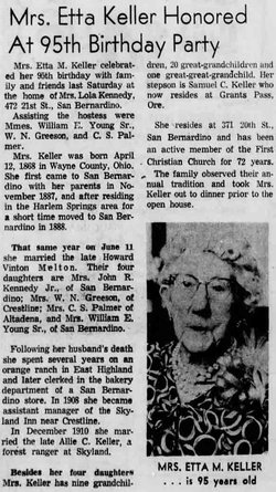
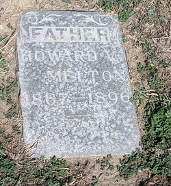
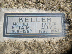
Henrietta “Etta” Hattery Melton Keller
| Birth | : | 12 Apr 1868 Wayne County, Ohio, USA |
| Death | : | 9 Apr 1967 San Bernardino, San Bernardino County, California, USA |
| Burial | : | Westbury General Cemetery, Westbury, Meander Valley Council, Australia |
| Coordinate | : | -41.5319850, 146.8259020 |
| Plot | : | block4-7-8-space 3 |
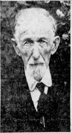
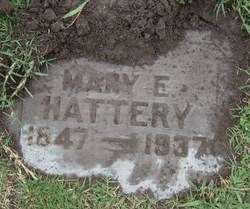
| Description | : | Etta's parents were: Capt. Jeremiah Lewis Hattery, b. Sep. 1846 in Bethlehem Township, Stark County, OH. and d. Jan. 21, 1932 in Long Beach, Los Angeles County, CA. & Mary Elizabeth Barnhart, b. Jun. 12, 1847 in Mount Pleasant, Westmoreland County, PA. and d. Mar. 28, 1937 in San Bernardino, San Bernardino County, CA. In the 1870 U. S. census, 2 yr. old Hettie (Etta) Hattery, b. in OH., was living in East Union, Wayne, OH. with her 26 yr. old (inferred) father, Jen Hattery, a farmer, b. in OH. 23 yr. old (inferred)... Read More |
frequently asked questions (FAQ):
-
Where is Henrietta “Etta” Hattery Melton Keller's memorial?
Henrietta “Etta” Hattery Melton Keller's memorial is located at: Westbury General Cemetery, Westbury, Meander Valley Council, Australia.
-
When did Henrietta “Etta” Hattery Melton Keller death?
Henrietta “Etta” Hattery Melton Keller death on 9 Apr 1967 in San Bernardino, San Bernardino County, California, USA
-
Where are the coordinates of the Henrietta “Etta” Hattery Melton Keller's memorial?
Latitude: -41.5319850
Longitude: 146.8259020
Family Members:
Parent
Spouse
Siblings
Children
Flowers:


Nearby Cemetories:
1. Westbury General Cemetery
Westbury, Meander Valley Council, Australia
Coordinate: -41.5319850, 146.8259020
2. Westbury Uniting Church Cemetery
Westbury, Meander Valley Council, Australia
Coordinate: -41.5316580, 146.8318780
3. Westbury Pioneer Catholic Cemetery
Westbury, Meander Valley Council, Australia
Coordinate: -41.5333340, 146.8393990
4. Culzean Cemetery
Westbury, Meander Valley Council, Australia
Coordinate: -41.5212380, 146.8339060
5. Hagley Methodist-Uniting Cemetery
Hagley, Meander Valley Council, Australia
Coordinate: -41.5258094, 146.8881433
6. Hagley Presbyterian Cemetery
Hagley, Meander Valley Council, Australia
Coordinate: -41.5255610, 146.8975560
7. St. Mary's Anglican Church Cemetery
Hagley, Meander Valley Council, Australia
Coordinate: -41.5217840, 146.9104460
8. Whitemore Methodist-Uniting Cemetery
Whitemore, Meander Valley Council, Australia
Coordinate: -41.5810490, 146.9325240
9. Saint Mark's Anglican Cemetery
Deloraine, Meander Valley Council, Australia
Coordinate: -41.5250850, 146.6600750
10. Carrick Anglican Churchyard
Carrick, Meander Valley Council, Australia
Coordinate: -41.5306800, 147.0075400
11. Bracknell General Cemetery
Bracknell, Meander Valley Council, Australia
Coordinate: -41.6436630, 146.9398520
12. Holy Nativity Anglican Cemetery
Bishopsbourne, Northern Midlands Council, Australia
Coordinate: -41.6173490, 146.9869290
13. Bracknell Presbyterian Cemetery
Bracknell, Meander Valley Council, Australia
Coordinate: -41.6518889, 146.9420278
14. Deloraine General Cemetery
Deloraine, Meander Valley Council, Australia
Coordinate: -41.5077836, 146.6302915
15. Mountain Vale Methodist Cemetery
Liffey, Northern Midlands Council, Australia
Coordinate: -41.6728910, 146.8919670
16. Frankford Cemetery
Frankford, West Tamar Council, Australia
Coordinate: -41.3611110, 146.8022220
17. Church Of The Good Shepherd
Hadspen, Meander Valley Council, Australia
Coordinate: -41.5076150, 147.0618590
18. Hadspen Uniting Church Cemetery
Hadspen, Meander Valley Council, Australia
Coordinate: -41.5064200, 147.0637300
19. Illawarra Christ Church Cemetery
Carrick, Meander Valley Council, Australia
Coordinate: -41.5502380, 147.0651810
20. Meander Cemetery
Meander, Meander Valley Council, Australia
Coordinate: -41.6493140, 146.6173550
21. St. Canice Catholic Cemetery
Glengarry, West Tamar Council, Australia
Coordinate: -41.3350250, 146.8701150
22. Blackwood Creek Community Church Cemetery
Blackwood Creek, Northern Midlands Council, Australia
Coordinate: -41.7400164, 146.8934466
23. St Augustine Catholic Church Cemetery
Longford, Northern Midlands Council, Australia
Coordinate: -41.5932650, 147.1140900
24. Longford General Cemetery
Longford, Northern Midlands Council, Australia
Coordinate: -41.6223790, 147.1055480