
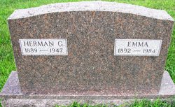
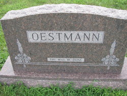
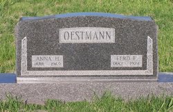
Herman Gottfried Oestmann
| Birth | : | 4 Jun 1889 Auburn, Nemaha County, Nebraska, USA |
| Death | : | 19 Mar 1947 Aurora, Arapahoe County, Colorado, USA |
| Burial | : | McCleary Cemetery, Jefferson County, USA |
| Coordinate | : | 40.9892006, -92.0805969 |
| Plot | : | Lot 7. Plot 2 |
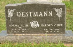
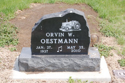
| Description | : | Son of Herman Ernst Heinrich Friedrich Diedrich Oestmann and Sophia Caroline Zabel. Husband to Emma Torbeck, daughter of Reiner Hillrichs Torbeck and Christina Dirks. Emma and Herman wed on February 4, 1913 at St. Johns (Stone)Lutheran Church, rural Auburn, Nebraska. Children 1. Ernestine Sophia Dora Oestmann, 1914–1984, married Adolph Friederich Gustoph Lunzmann 2. Verna Christine Wilhelmine Oestmann, 1916–1991, married Vern Moody 3. Eileen Laura Oestmann, 1918–1995, married Harold Roy Coulter 4. Harold Omer Oestmann, 1924–2016, married Norma Ruth Zorn 5. Orvin Wesley Oestmann, 1927–2010 U.S., Evangelical Lutheran Church in America Church Records, 1781-1969 Name: Herman Gottfried... Read More |
frequently asked questions (FAQ):
-
Where is Herman Gottfried Oestmann's memorial?
Herman Gottfried Oestmann's memorial is located at: McCleary Cemetery, Jefferson County, USA.
-
When did Herman Gottfried Oestmann death?
Herman Gottfried Oestmann death on 19 Mar 1947 in Aurora, Arapahoe County, Colorado, USA
-
Where are the coordinates of the Herman Gottfried Oestmann's memorial?
Latitude: 40.9892006
Longitude: -92.0805969
Family Members:
Parent
Spouse

Siblings
Children
Flowers:


Nearby Cemetories:
1. McCleary Cemetery
Jefferson County, USA
Coordinate: 40.9892006, -92.0805969
2. Morgan Burial Plot
Des Moines Township, Jefferson County, USA
Coordinate: 40.9837160, -92.0964340
3. Gregg Cemetery
Jefferson County, USA
Coordinate: 41.0078011, -92.0811005
4. Smith Family Cemetery
Libertyville, Jefferson County, USA
Coordinate: 40.9972416, -92.0362857
5. Brethren Cemetery
Batavia, Jefferson County, USA
Coordinate: 40.9768000, -92.1240000
6. Koons Cemetery
Locust Grove Township, Jefferson County, USA
Coordinate: 41.0286410, -92.0948960
7. Coon Cemetery
Jefferson County, USA
Coordinate: 41.0266991, -92.1243973
8. Fell Cemetery
Libertyville, Jefferson County, USA
Coordinate: 40.9375000, -92.0772018
9. Moorman Cemetery
Fairfield, Jefferson County, USA
Coordinate: 41.0452995, -92.0622025
10. Gantz Cemetery
Abingdon, Jefferson County, USA
Coordinate: 41.0464000, -92.1017000
11. Batavia Cemetery
Batavia, Jefferson County, USA
Coordinate: 40.9977080, -92.1661100
12. Walnut Hill Cemetery
Jefferson County, USA
Coordinate: 41.0416985, -92.1355972
13. Rominger Cemetery
Batavia, Jefferson County, USA
Coordinate: 40.9379000, -92.1503000
14. Bradfield Plot
Locust Grove Township, Jefferson County, USA
Coordinate: 41.0615330, -92.1014040
15. Brooks Cemetery
Jefferson County, USA
Coordinate: 41.0635986, -92.0693970
16. Courtney Cemetery
Jefferson County, USA
Coordinate: 40.9997711, -92.1788559
17. Jefferson County Poor Farm Cemetery
Libertyville, Jefferson County, USA
Coordinate: 40.9416900, -91.9996200
18. Memorial Lawn Cemetery
Fairfield, Jefferson County, USA
Coordinate: 41.0068000, -91.9805000
19. Holmes Family Cemetery
Batavia, Jefferson County, USA
Coordinate: 41.0175666, -92.1785349
20. Winsell Cemetery
Fairfield, Jefferson County, USA
Coordinate: 40.9067001, -92.1247025
21. Cumberland Cemetery
Jefferson County, USA
Coordinate: 40.9248000, -91.9903000
22. Old Fairfield Cemetery
Fairfield, Jefferson County, USA
Coordinate: 41.0148000, -91.9598000
23. Evergreen Cemetery
Fairfield, Jefferson County, USA
Coordinate: 41.0138600, -91.9562100
24. Roth Cemetery
Fairfield, Jefferson County, USA
Coordinate: 40.9589005, -91.9574966