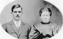
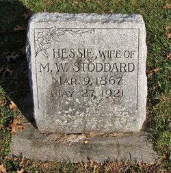
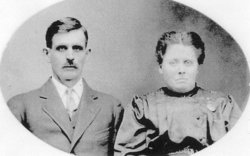
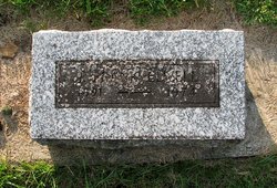
Hessie E. Jones Stoddard
| Birth | : | 9 Mar 1867 Nelsonville, Athens County, Ohio, USA |
| Death | : | 27 May 1921 Waverly, Bremer County, Iowa, USA |
| Burial | : | Union Grove Baptist Cemetery, Union Grove, Blount County, USA |
| Coordinate | : | 35.5883000, -84.1333000 |
| Description | : | Hessie E. Jones was born March 9, 1867, in Nelsonville, Athens County, Ohio, to Graham Franklin and Lucia Woodworth Jones. She traveled to Iowa with her family in 1875. She married William W. Elwell on November 9, 1890, in Glenwood, Mills County, Iowa. Their son, James Frank Elwell, was born July 20, 1891. William Elwell was a farmer, originally from Grant County, Wisconsin. Hessie and William divorced on December 5, 1899. In 1900 Hessie was housekeeper in the home of A.D. Putnam of Center Township, Pottawattamie County, Iowa. Hessie was briefly married to Albert... Read More |
frequently asked questions (FAQ):
-
Where is Hessie E. Jones Stoddard's memorial?
Hessie E. Jones Stoddard's memorial is located at: Union Grove Baptist Cemetery, Union Grove, Blount County, USA.
-
When did Hessie E. Jones Stoddard death?
Hessie E. Jones Stoddard death on 27 May 1921 in Waverly, Bremer County, Iowa, USA
-
Where are the coordinates of the Hessie E. Jones Stoddard's memorial?
Latitude: 35.5883000
Longitude: -84.1333000
Family Members:
Parent
Spouse
Siblings
Children
Flowers:
Nearby Cemetories:
1. Union Grove Baptist Cemetery
Union Grove, Blount County, USA
Coordinate: 35.5883000, -84.1333000
2. Bacon-Henley Cemetery
Monroe County, USA
Coordinate: 35.5691986, -84.1418991
3. Smyrna Baptist Church Cemetery
Blount County, USA
Coordinate: 35.6182750, -84.1444480
4. Chota Memorial
Monroe County, USA
Coordinate: 35.5552670, -84.1315750
5. Montgomery Cemetery
Blount County, USA
Coordinate: 35.6030998, -84.1735992
6. Howard Chapel Missionary Baptist Church Cemetery
Vonore, Monroe County, USA
Coordinate: 35.5560989, -84.1541977
7. Liberty Baptist Church Cemetery
Maryville, Blount County, USA
Coordinate: 35.6260986, -84.1335983
8. Williamson Chapel Cemetery
Maryville, Blount County, USA
Coordinate: 35.6206017, -84.1074982
9. Four Mile Cemetery
Maryville, Blount County, USA
Coordinate: 35.5931015, -84.0832977
10. Garner Family Cemetery
Blount County, USA
Coordinate: 35.6232300, -84.1065100
11. Faith Deliverance Church Cemetery
Blount County, USA
Coordinate: 35.6164200, -84.0946100
12. McGhee Cemetery
Monroe County, USA
Coordinate: 35.5823700, -84.1917600
13. Toqua Graveyard
Vonore, Monroe County, USA
Coordinate: 35.5816667, -84.1941667
14. Nelson Chapel Cemetery
Blount County, USA
Coordinate: 35.6068993, -84.0757980
15. McGhee Cemetery
Vonore, Monroe County, USA
Coordinate: 35.5606003, -84.1893997
16. Oakland United Methodist Church Cemetery
Monroe County, USA
Coordinate: 35.6143990, -84.1913986
17. Toqua Cemetery
Toqua, Monroe County, USA
Coordinate: 35.5788880, -84.2058333
18. Niles-McGhee Cemetery
Monroe County, USA
Coordinate: 35.6025009, -84.2052994
19. Pine Grove Presbyterian Church Cemetery
Greenback, Loudon County, USA
Coordinate: 35.6527800, -84.1535600
20. Allegheny Baptist Church Cemetery
Maryville, Blount County, USA
Coordinate: 35.5923040, -84.0510180
21. Riverbend Farm Cemetery
Greenback, Loudon County, USA
Coordinate: 35.6238850, -84.2040080
22. Bingham Cemetery
Loudon County, USA
Coordinate: 35.6555200, -84.1440500
23. Crossroads Tabernacle Cemetery
Blount County, USA
Coordinate: 35.6555000, -84.1173600
24. McCollum Family Cemetery
Glendale, Loudon County, USA
Coordinate: 35.6425185, -84.1852114


