
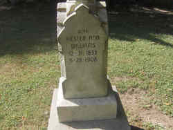

Hester Ann Williams Lewis
| Birth | : | 31 Dec 1833 Ross County, Ohio, USA |
| Death | : | 28 May 1908 Parke County, Indiana, USA |
| Burial | : | Saint Marys Cemetery, Guttenberg, Clayton County, USA |
| Coordinate | : | 42.7691994, -91.1352997 |
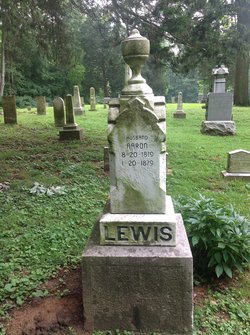
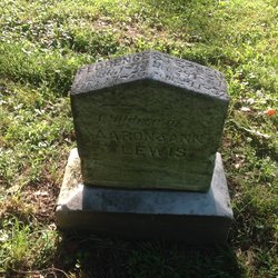
| Description | : | Hester Ann Lewis, nee Williams, was born in Ross Co, Ohio, Dec. 31, 1833. At about the age of 6 years, she with her parents, moved to Parke County, Indiana, settling in the vicinity of Sand Creek, where she grew to womanhood, and where, on Sept 19, 1851, she was united in marriage to Aaron Lewis. She and her husband continued to live in this vicinity until his death, and for many years afterward, she made her home in this part of the county. She became the mother of 8 children. Six of whom still... Read More |
frequently asked questions (FAQ):
-
Where is Hester Ann Williams Lewis's memorial?
Hester Ann Williams Lewis's memorial is located at: Saint Marys Cemetery, Guttenberg, Clayton County, USA.
-
When did Hester Ann Williams Lewis death?
Hester Ann Williams Lewis death on 28 May 1908 in Parke County, Indiana, USA
-
Where are the coordinates of the Hester Ann Williams Lewis's memorial?
Latitude: 42.7691994
Longitude: -91.1352997
Family Members:
Spouse
Children


Flowers:


Nearby Cemetories:
1. Saint Marys Cemetery
Guttenberg, Clayton County, USA
Coordinate: 42.7691994, -91.1352997
2. Mount Olivet Cemetery
Guttenberg, Clayton County, USA
Coordinate: 42.7764840, -91.1083560
3. Guttenberg Cemetery
Guttenberg, Clayton County, USA
Coordinate: 42.7691994, -91.1035995
4. Saint Johns Cemetery
Jefferson Township, Clayton County, USA
Coordinate: 42.7497000, -91.1133000
5. Storck Cemetery
Guttenberg, Clayton County, USA
Coordinate: 42.7694335, -91.1834638
6. Lewis Cemetery
Osterdock, Clayton County, USA
Coordinate: 42.7416000, -91.1834000
7. Saint Paula Cemetery
Osterdock, Clayton County, USA
Coordinate: 42.7635994, -91.1992035
8. Saint Michael Cemetery
Clayton County, USA
Coordinate: 42.8055992, -91.1802979
9. Borcherding Cemetery
Jefferson Township, Clayton County, USA
Coordinate: 42.8182983, -91.1414032
10. Bierer Cemetery
Millville, Clayton County, USA
Coordinate: 42.7230500, -91.0925166
11. Old Saint Marys Cemetery
Glen Haven, Grant County, USA
Coordinate: 42.8078100, -91.0675330
12. Friedlein Cemetery
Millville, Clayton County, USA
Coordinate: 42.7080994, -91.1108017
13. Redman Cemetery
Millville, Clayton County, USA
Coordinate: 42.7166755, -91.0852901
14. Pioneer Rock Cemetery
Ceres, Clayton County, USA
Coordinate: 42.8230591, -91.1863937
15. Bethel Cemetery
Osterdock, Clayton County, USA
Coordinate: 42.7041702, -91.1688919
16. Charlotte Cemetery
Glen Haven, Grant County, USA
Coordinate: 42.7933006, -91.0381012
17. McClelland Cemetery
Garnavillo, Clayton County, USA
Coordinate: 42.8249879, -91.2084641
18. Duncan Cemetery
Glen Haven, Grant County, USA
Coordinate: 42.8325540, -91.0725940
19. Graham Cemetery
Millville, Clayton County, USA
Coordinate: 42.6833172, -91.1195685
20. Gockel Cemetery
Glen Haven, Grant County, USA
Coordinate: 42.8224983, -91.0385971
21. Tangeman Family Cemetery
Garnavillo, Clayton County, USA
Coordinate: 42.8580000, -91.1420000
22. Old Garber Cemetery
Garber, Clayton County, USA
Coordinate: 42.7560005, -91.2580032
23. Bolsinger Cemetery
Mallory Township, Clayton County, USA
Coordinate: 42.6776340, -91.1424090
24. Goshen Cemetery
Millville, Clayton County, USA
Coordinate: 42.6905594, -91.0544434