

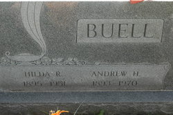
Hilda R Hoop Buell
| Birth | : | 25 Aug 1895 Goose Lake, Clinton County, Iowa, USA |
| Death | : | 19 Dec 1951 Clinton, Clinton County, Iowa, USA |
| Burial | : | Blessed Virgin Mary Churchyard, Compton Dando, Bath and North East Somerset Unitary Authority, England |
| Coordinate | : | 51.3796870, -2.5100920 |
frequently asked questions (FAQ):
-
Where is Hilda R Hoop Buell's memorial?
Hilda R Hoop Buell's memorial is located at: Blessed Virgin Mary Churchyard, Compton Dando, Bath and North East Somerset Unitary Authority, England.
-
When did Hilda R Hoop Buell death?
Hilda R Hoop Buell death on 19 Dec 1951 in Clinton, Clinton County, Iowa, USA
-
Where are the coordinates of the Hilda R Hoop Buell's memorial?
Latitude: 51.3796870
Longitude: -2.5100920
Family Members:
Parent

Spouse
Siblings
Children
Flowers:


Nearby Cemetories:
1. Blessed Virgin Mary Churchyard
Compton Dando, Bath and North East Somerset Unitary Authority, England
Coordinate: 51.3796870, -2.5100920
2. Saint Michael Churchyard
Keynsham, Bath and North East Somerset Unitary Authority, England
Coordinate: 51.3865690, -2.4830350
3. All Saints Churchyard
Publow, Bath and North East Somerset Unitary Authority, England
Coordinate: 51.3751100, -2.5423600
4. Queen Charlton St. Margaret Churchyard
Compton Dando, Bath and North East Somerset Unitary Authority, England
Coordinate: 51.4009300, -2.5271800
5. Saint Margaret Churchyard
Compton Dando, Bath and North East Somerset Unitary Authority, England
Coordinate: 51.4009330, -2.5272136
6. Saint Thomas Churchyard
Pensford, Bath and North East Somerset Unitary Authority, England
Coordinate: 51.3710450, -2.5495820
7. Pensford Methodist Churchyard
Pensford, Bath and North East Somerset Unitary Authority, England
Coordinate: 51.3731030, -2.5506730
8. Saint Leonard Churchyard
Chelwood, Bath and North East Somerset Unitary Authority, England
Coordinate: 51.3546300, -2.5246880
9. St. Peter's Church Cemetery
Marksbury, Bath and North East Somerset Unitary Authority, England
Coordinate: 51.3591670, -2.4802780
10. Whitchurch Cemetery
Bristol Unitary Authority, England
Coordinate: 51.3990278, -2.5506809
11. Saint Lawrence Churchyard
Stanton Prior, Bath and North East Somerset Unitary Authority, England
Coordinate: 51.3627780, -2.4638890
12. Saint Lawrence of Stanton Prior
Keynsham, Bath and North East Somerset Unitary Authority, England
Coordinate: 51.3626830, -2.4638780
13. Ebenezer Baptist Church
Keynsham, Bath and North East Somerset Unitary Authority, England
Coordinate: 51.4160710, -2.4983170
14. Holy Trinity Churchyard
Norton Malreward, Bath and North East Somerset Unitary Authority, England
Coordinate: 51.3831750, -2.5711360
15. St. John the Baptist Churchyard
Keynsham, Bath and North East Somerset Unitary Authority, England
Coordinate: 51.4174570, -2.4987140
16. Keynsham Abbey
Keynsham, Bath and North East Somerset Unitary Authority, England
Coordinate: 51.4172000, -2.4961000
17. All Saints Churchyard
Farmborough, Bath and North East Somerset Unitary Authority, England
Coordinate: 51.3430620, -2.4876590
18. Keynsham Cemetery
Keynsham, Bath and North East Somerset Unitary Authority, England
Coordinate: 51.4212975, -2.5116095
19. All Saints Churchyard
Corston, Bath and North East Somerset Unitary Authority, England
Coordinate: 51.3857350, -2.4400372
20. Blessed Virgin Mary Churchyard
Saltford, Bath and North East Somerset Unitary Authority, England
Coordinate: 51.4056845, -2.4528274
21. St Mary the Virgin Churchyard
Stanton Drew, Bath and North East Somerset Unitary Authority, England
Coordinate: 51.3657390, -2.5788440
22. Holy Trinity Churchyard
Newton St Loe, Bath and North East Somerset Unitary Authority, England
Coordinate: 51.3820470, -2.4311300
23. St. Nicholas Churchyard
Kelston, Bath and North East Somerset Unitary Authority, England
Coordinate: 51.4006420, -2.4344010
24. St. Mary Churchyard
Bitton, South Gloucestershire Unitary Authority, England
Coordinate: 51.4223600, -2.4599100