

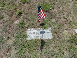

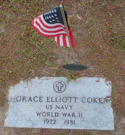
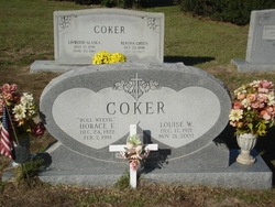
Horace Eliott Coker
| Birth | : | 24 Dec 1922 Clarendon County, South Carolina, USA |
| Death | : | 7 Feb 1981 Clarendon County, South Carolina, USA |
| Burial | : | St. John the Baptist Churchyard, Meopham, Gravesham Borough, England |
| Coordinate | : | 51.3713500, 0.3615600 |
| Inscription | : | US Navy World War II |
| Description | : | Inscription: "Boll Weevil" "US Navy, World War II" Wife: Louise W. Coker "Married Sept. 5, 1974" |
frequently asked questions (FAQ):
-
Where is Horace Eliott Coker's memorial?
Horace Eliott Coker's memorial is located at: St. John the Baptist Churchyard, Meopham, Gravesham Borough, England.
-
When did Horace Eliott Coker death?
Horace Eliott Coker death on 7 Feb 1981 in Clarendon County, South Carolina, USA
-
Where are the coordinates of the Horace Eliott Coker's memorial?
Latitude: 51.3713500
Longitude: 0.3615600
Family Members:
Parent
Spouse
Siblings
Flowers:


Nearby Cemetories:
1. St. John the Baptist Churchyard
Meopham, Gravesham Borough, England
Coordinate: 51.3713500, 0.3615600
2. Meopham Cemetery
Meopham, Gravesham Borough, England
Coordinate: 51.3709100, 0.3600900
3. St Mildred Churchyard
Nurstead, Gravesham Borough, England
Coordinate: 51.3902931, 0.3574180
4. St Peter and St Paul Churchyard
Luddesdown, Gravesham Borough, England
Coordinate: 51.3700218, 0.3974010
5. All Saints Churchyard
Hartley, Sevenoaks District, England
Coordinate: 51.3761177, 0.3164520
6. Hartley Parish Burial Ground
Hartley, Sevenoaks District, England
Coordinate: 51.3765290, 0.3164040
7. St. Mary Magdalene New Churchyard
Cobham, Gravesham Borough, England
Coordinate: 51.3899060, 0.3983090
8. Cobham War Memorial
Cobham, Gravesham Borough, England
Coordinate: 51.3900719, 0.4043670
9. St. Margaret Churchyard
Cobham, Gravesham Borough, England
Coordinate: 51.4059906, 0.3749080
10. St Peter and St Paul Churchyard
Ash, Sevenoaks District, England
Coordinate: 51.3575990, 0.2989910
11. St Mary Magdalene Churchyard
Longfield, Dartford Borough, England
Coordinate: 51.3978510, 0.3033730
12. St Mary Churchyard
Fawkham, Sevenoaks District, England
Coordinate: 51.3893970, 0.2938280
13. St Mary the Virgin Churchyard
Stansted, Tonbridge and Malling Borough, England
Coordinate: 51.3355120, 0.3060170
14. St Peter and St Paul Churchyard
Trottiscliffe, Tonbridge and Malling Borough, England
Coordinate: 51.3201520, 0.3612360
15. St. Benedict Churchyard
Snodland, Tonbridge and Malling Borough, England
Coordinate: 51.3332200, 0.4171600
16. St Nicholas Churchyard
Southfleet, Dartford Borough, England
Coordinate: 51.4165030, 0.3193850
17. Halling War Memorial
Halling, Medway Unitary Authority, England
Coordinate: 51.3519630, 0.4439060
18. Halling Church Cemetery
Halling, Medway Unitary Authority, England
Coordinate: 51.3499140, 0.4447960
19. St John the Baptist Churchyard
Halling, Medway Unitary Authority, England
Coordinate: 51.3484993, 0.4468510
20. St. Michael and All Angels Churchyard
Cuxton, Medway Unitary Authority, England
Coordinate: 51.3714120, 0.4546760
21. Snodland Cemetery
Snodland, Tonbridge and Malling Borough, England
Coordinate: 51.3336110, 0.4348770
22. St Peter and St Paul Churchyard
Shorne, Gravesham Borough, England
Coordinate: 51.4132347, 0.4297970
23. All Saints Churchyard
Birling, Tonbridge and Malling Borough, England
Coordinate: 51.3197010, 0.4097520
24. Christ Church Milton-next-Gravesend
Gravesend, Gravesham Borough, England
Coordinate: 51.4317570, 0.3769340