

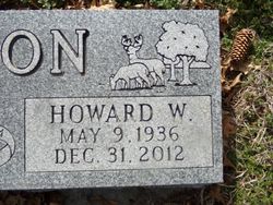
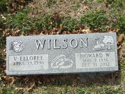
Howard Wayne Wilson
| Birth | : | 9 May 1936 |
| Death | : | 31 Dec 2012 Omaha, Douglas County, Nebraska, USA |
| Burial | : | Wesley Chapel Cemetery, Henderson, Mills County, USA |
| Coordinate | : | 41.1019249, -95.4987793 |
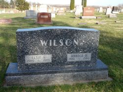
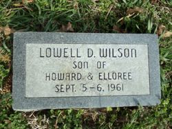
| Description | : | Howard Wayne Wilson, the only child of Elsie Viola (Harris) and Harold William Wilson, was born on May 9, 1936 on a farm near Henderson, Iowa. He grew up on the farm his parents had moved to in 1937 northwest of Hastings, Iowa. Howard attended school in Henderson through the 11th grade. He worked as a mechanic for a year at the John Deere dealership in Macedonia, Iowa and then began to help on the farm with his father, eventually taking over. Howard and Virginia Elloree Prine were married on August 22, 1954 in Pisgah, Iowa. They made their home... Read More |
frequently asked questions (FAQ):
-
Where is Howard Wayne Wilson's memorial?
Howard Wayne Wilson's memorial is located at: Wesley Chapel Cemetery, Henderson, Mills County, USA.
-
When did Howard Wayne Wilson death?
Howard Wayne Wilson death on 31 Dec 2012 in Omaha, Douglas County, Nebraska, USA
-
Where are the coordinates of the Howard Wayne Wilson's memorial?
Latitude: 41.1019249
Longitude: -95.4987793
Family Members:
Parent

Children
Flowers:


Nearby Cemetories:
1. Wesley Chapel Cemetery
Henderson, Mills County, USA
Coordinate: 41.1019249, -95.4987793
2. Saylers Farm Cemetery
Henderson, Mills County, USA
Coordinate: 41.1083300, -95.4919440
3. Cotten Cemetery
Mills County, USA
Coordinate: 41.0845000, -95.5167000
4. Wearin Cemetery
Malvern, Mills County, USA
Coordinate: 41.0395000, -95.5313000
5. Farm Creek Cemetery
Henderson, Mills County, USA
Coordinate: 41.1319008, -95.4186020
6. East Liberty Cemetery
Malvern, Mills County, USA
Coordinate: 41.0592346, -95.6005020
7. North Grove Cemetery
Hastings, Mills County, USA
Coordinate: 41.0161018, -95.4618988
8. Hastings Cemetery
Hastings, Mills County, USA
Coordinate: 41.0097008, -95.4993973
9. Emerson Cemetery
Emerson, Mills County, USA
Coordinate: 41.0325012, -95.4021988
10. Lowens Cemetery
Garfield Township, Montgomery County, USA
Coordinate: 41.0527728, -95.3758292
11. Silver City Cemetery
Silver City, Mills County, USA
Coordinate: 41.1042442, -95.6380005
12. Macedonia Cemetery
Macedonia, Pottawattamie County, USA
Coordinate: 41.1921997, -95.4167023
13. Old Town Cemetery
Macedonia, Pottawattamie County, USA
Coordinate: 41.2030983, -95.4421997
14. South Grove Cemetery
Mills County, USA
Coordinate: 40.9775009, -95.4931030
15. Malvern Cemetery
Malvern, Mills County, USA
Coordinate: 40.9886017, -95.5785980
16. Parker Cemetery
White Cloud, Mills County, USA
Coordinate: 40.9737649, -95.5184363
17. Buckner Cemetery
Wales, Montgomery County, USA
Coordinate: 41.1595600, -95.3440700
18. Mormon Cemetery
Macedonia, Pottawattamie County, USA
Coordinate: 41.1885986, -95.3557663
19. Hillsdale Cemetery
Glenwood, Mills County, USA
Coordinate: 41.0097008, -95.6427994
20. Gomer Cemetery
Wales, Montgomery County, USA
Coordinate: 41.1171989, -95.3082962
21. Mills County Farm Cemetery
Glenwood, Mills County, USA
Coordinate: 41.0417930, -95.6756530
22. Mineola Cemetery
Mineola, Mills County, USA
Coordinate: 41.1391130, -95.6941800
23. Zion Congregational Cemetery
Treynor, Pottawattamie County, USA
Coordinate: 41.2325090, -95.6079200
24. Carson Cemetery
Carson, Pottawattamie County, USA
Coordinate: 41.2392006, -95.4044037