

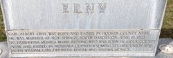
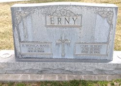
Hubertina Monica Marie Ruffing Erny
| Birth | : | 3 Nov 1900 Montrose, Sioux County, Nebraska, USA |
| Death | : | 17 Oct 2004 Alliance, Box Butte County, Nebraska, USA |
| Burial | : | St. James Churchyard, Lower Hutt, Lower Hutt City, New Zealand |
| Coordinate | : | -41.2128840, 174.9003910 |
| Description | : | Hubertina Monica Marie Erny, 103, of Alliance, Nebr., died Oct. 17, at the Good Samaritan Health Care Center. Funeral services were held Oct. 21 at Holy Rosary Catholic Church in Alliance with Father Bryan Ernest officiating. Burial was at Calvary Cemetery. A wake service was held Oct. 20, 7 p.m. at the church. Memorial may be directed to St. Agnes Academy, 1104 Cheyenne, Alliance, NE. 69301 or Good Samaritan Health Care Center, P.O. Box 970, Alliance, NE 69301. Monica was born Nov. 3, 1900, the oldest of nine children, near Montrose in Sioux County, to Christ and Gertrude (Marking) Ruffing. The family... Read More |
frequently asked questions (FAQ):
-
Where is Hubertina Monica Marie Ruffing Erny's memorial?
Hubertina Monica Marie Ruffing Erny's memorial is located at: St. James Churchyard, Lower Hutt, Lower Hutt City, New Zealand.
-
When did Hubertina Monica Marie Ruffing Erny death?
Hubertina Monica Marie Ruffing Erny death on 17 Oct 2004 in Alliance, Box Butte County, Nebraska, USA
-
Where are the coordinates of the Hubertina Monica Marie Ruffing Erny's memorial?
Latitude: -41.2128840
Longitude: 174.9003910
Family Members:
Parent
Spouse
Siblings
Children

Flowers:


Nearby Cemetories:
1. St. James Churchyard
Lower Hutt, Lower Hutt City, New Zealand
Coordinate: -41.2128840, 174.9003910
2. Bridge Street Cemetery
Lower Hutt, Lower Hutt City, New Zealand
Coordinate: -41.2117740, 174.8969660
3. Boulcott Farm Cemetery
Lower Hutt, Lower Hutt City, New Zealand
Coordinate: -41.2030590, 174.9272750
4. Owhiti Urupā
Seaview, Lower Hutt City, New Zealand
Coordinate: -41.2358800, 174.9044500
5. Korokoro Catholic Cemetery
Lower Hutt, Lower Hutt City, New Zealand
Coordinate: -41.2210110, 174.8702590
6. Te Puni Urupā
Petone, Lower Hutt City, New Zealand
Coordinate: -41.2254898, 174.8686975
7. Taita Old Cemetery
Naenae, Lower Hutt City, New Zealand
Coordinate: -41.1945700, 174.9564000
8. Knox Presbyterian Church Cemetery
Lower Hutt, Lower Hutt City, New Zealand
Coordinate: -41.1965430, 174.9579920
9. Somes Island
Wellington, Wellington City, New Zealand
Coordinate: -41.2548630, 174.8650830
10. Taita Lawn Cemetery
Naenae, Lower Hutt City, New Zealand
Coordinate: -41.1968900, 174.9634900
11. Christ Church Anglican Cemetery
Taita, Lower Hutt City, New Zealand
Coordinate: -41.1820960, 174.9600920
12. Woodlands Farm Cemetery
Wainuiomata, Lower Hutt City, New Zealand
Coordinate: -41.2587540, 174.9549250
13. Johnsonville Methodist Cemetery
Wellington, Wellington City, New Zealand
Coordinate: -41.2229000, 174.8083500
14. St. John's Anglican Churchyard Cemetery
Johnsonville, Wellington City, New Zealand
Coordinate: -41.2201300, 174.8076800
15. Grasslees Reserve
Tawa, Wellington City, New Zealand
Coordinate: -41.1647415, 174.8284302
16. Homedale Methodist Cemetery
Wainuiomata, Lower Hutt City, New Zealand
Coordinate: -41.2780500, 174.9527000
17. Tawa Flat Cemetery
Tawa, Wellington City, New Zealand
Coordinate: -41.1580600, 174.8281800
18. Porirua Cemetery
Porirua, Porirua City, New Zealand
Coordinate: -41.1453640, 174.8420300
19. Wainuiomata Remembrance Garden
Wainuiomata, Lower Hutt City, New Zealand
Coordinate: -41.2762300, 174.9696800
20. Sinclair Cemetery
Wainuiomata, Lower Hutt City, New Zealand
Coordinate: -41.2770470, 174.9697580
21. Massey Memorial
Wellington, Wellington City, New Zealand
Coordinate: -41.2850700, 174.8259900
22. Holy Trinity Cemetery
Ohariu, Wellington City, New Zealand
Coordinate: -41.2000860, 174.7793400
23. Bradey Grave
Whitby, Porirua City, New Zealand
Coordinate: -41.1173161, 174.9056161
24. Ngati Toa Street Urupā
Takapuwahia, Porirua City, New Zealand
Coordinate: -41.1264070, 174.8344310