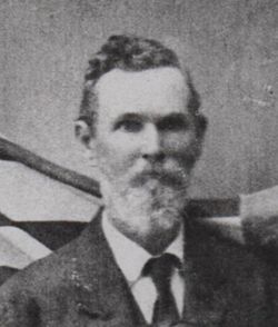
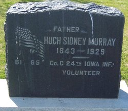
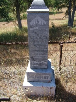
Hugh Sidney Murray
| Birth | : | 7 Mar 1843 County Down, Northern Ireland |
| Death | : | 22 May 1929 Santa Cruz, Santa Cruz County, California, USA |
| Burial | : | St. Michael and All Angels Churchyard, Bunwell, South Norfolk District, England |
| Coordinate | : | 52.4914460, 1.1296800 |
| Description | : | Hugh Sydney Murray was born in Ireland in 1843. He was 18-years-old and a resident of Tipton, Iowa, when he enlisted on August 15, 1862. He mustered in as a Private on August 29, 1862, into Company C, 24th Iowa Infantry. He was wounded in action at Champion's Hill, Mississippi, on May 16, 1863, and discharged for wounds on March 27, 1864, at Alexandria, Virginia. He appears as a member of Lompoc's Anderson Post, No. 66, Grand Army of the Republic, in 1886. He remained a member of the Post until his death in 1929. |
frequently asked questions (FAQ):
-
Where is Hugh Sidney Murray's memorial?
Hugh Sidney Murray's memorial is located at: St. Michael and All Angels Churchyard, Bunwell, South Norfolk District, England.
-
When did Hugh Sidney Murray death?
Hugh Sidney Murray death on 22 May 1929 in Santa Cruz, Santa Cruz County, California, USA
-
Where are the coordinates of the Hugh Sidney Murray's memorial?
Latitude: 52.4914460
Longitude: 1.1296800
Family Members:
Parent
Siblings
Flowers:
Nearby Cemetories:
1. St. Michael and All Angels Churchyard
Bunwell, South Norfolk District, England
Coordinate: 52.4914460, 1.1296800
2. Carleton Rode Baptist Churchyard
Carleton Rode, South Norfolk District, England
Coordinate: 52.4937320, 1.1185210
3. All Saints Churchyard
Carleton Rode, South Norfolk District, England
Coordinate: 52.4892230, 1.1133590
4. Methodist Churchyard
Forncett End, South Norfolk District, England
Coordinate: 52.4993440, 1.1545110
5. St Michael Churchyard
Aslacton, South Norfolk District, England
Coordinate: 52.4750490, 1.1737040
6. St Peter Churchyard
Forncett, South Norfolk District, England
Coordinate: 52.4906450, 1.1862950
7. St Mary Churchyard
Forncett, South Norfolk District, England
Coordinate: 52.4994380, 1.1897810
8. St. Martin's Churchyard
New Buckenham, Breckland Borough, England
Coordinate: 52.4728860, 1.0728380
9. St. Michael's Churchyard
Great Moulton, South Norfolk District, England
Coordinate: 52.4718860, 1.1868760
10. Saint Nicholas Churchyard
Fundenhall, South Norfolk District, England
Coordinate: 52.5275430, 1.1717020
11. All Saints Churchyard
Ashwellthorpe, South Norfolk District, England
Coordinate: 52.5346560, 1.1638810
12. Buckenham Priory
Buckenham, Broadland District, England
Coordinate: 52.4911000, 1.0497000
13. All Saints Churchyard
Old Buckenham, Breckland Borough, England
Coordinate: 52.4816260, 1.0433160
14. St. Margaret Churchyard
Hapton, South Norfolk District, England
Coordinate: 52.5244110, 1.2066410
15. All Saints Churchyard
Besthorpe, Breckland Borough, England
Coordinate: 52.5192800, 1.0431370
16. Long Stratton Congregational Churchyard
Long Stratton, South Norfolk District, England
Coordinate: 52.4818890, 1.2324460
17. St Mary's Churchyard
Long Stratton, South Norfolk District, England
Coordinate: 52.4840800, 1.2339000
18. St. Mary the Virgin Churchyard
Banham, Breckland Borough, England
Coordinate: 52.4529230, 1.0353120
19. Saint Mary Churchyard
Gissing, South Norfolk District, England
Coordinate: 52.4235630, 1.1548260
20. St Michael And All Saint's
Flordon, South Norfolk District, England
Coordinate: 52.5294700, 1.2261400
21. Parkside Garden
Attleborough, Breckland Borough, England
Coordinate: 52.5167420, 1.0209100
22. Theddingworth Congregational Church yard
Theddingworth, Harborough District, England
Coordinate: 52.4644400, 1.0211700
23. St Mary's Churchyard Extension
Banham, Breckland Borough, England
Coordinate: 52.4549400, 1.0274400
24. Blessed Virgin Mary Churchyard
Attleborough, Breckland Borough, England
Coordinate: 52.5178950, 1.0181880


