

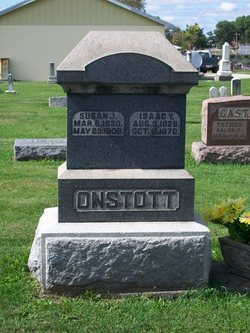
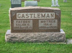
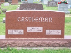
Ida Jane Onstott Castleman
| Birth | : | 1 Jun 1856 Miami County, Indiana, USA |
| Death | : | 4 Oct 1930 Fulton County, Indiana, USA |
| Burial | : | Pleasant View Cemetery, Athol, Smith County, USA |
| Coordinate | : | 39.7859000, -98.8982000 |
| Plot | : | Section 3, Row 2 |
| Description | : | Published in the Rochester(IN) News-Sentinel, Saturday, October 4, 1930 Mrs. Caleb CASTLEMAN, 74, died at 8:10 Saturday morning in her home eight miles west of Rochester in the Loyal community, death being due to complications of diseases. Mrs. Castleman had been in ill health for the past five years but her condition had only been regarded as serious one week. The deceased had lived near Loyal for many years and was one of the best known residents of that community. Ida Jane [ONSTOTT], daughter of Isaac and Susan ONSTOTT, was born in Miami county June 1, 1856, and came... Read More |
frequently asked questions (FAQ):
-
Where is Ida Jane Onstott Castleman's memorial?
Ida Jane Onstott Castleman's memorial is located at: Pleasant View Cemetery, Athol, Smith County, USA.
-
When did Ida Jane Onstott Castleman death?
Ida Jane Onstott Castleman death on 4 Oct 1930 in Fulton County, Indiana, USA
-
Where are the coordinates of the Ida Jane Onstott Castleman's memorial?
Latitude: 39.7859000
Longitude: -98.8982000
Family Members:
Parent

Spouse
Siblings
Children
Flowers:


Nearby Cemetories:
1. Pleasant View Cemetery
Athol, Smith County, USA
Coordinate: 39.7859000, -98.8982000
2. Saint John Lutheran Cemetery
Athol, Smith County, USA
Coordinate: 39.7269900, -98.8971600
3. Zion Cemetery
Athol, Smith County, USA
Coordinate: 39.8434100, -98.9171700
4. Meade Cemetery
Reamsville, Smith County, USA
Coordinate: 39.8680992, -98.8839035
5. Fairview Cemetery
Smith Center, Smith County, USA
Coordinate: 39.7966995, -98.7881012
6. Christ Cemetery
Gaylord, Smith County, USA
Coordinate: 39.6988100, -98.8556700
7. Saint John Lutheran Cemetery
Kensington, Smith County, USA
Coordinate: 39.7744700, -99.0308700
8. William Nelson Gravesite
Athol, Smith County, USA
Coordinate: 39.8866080, -98.8708130
9. Cedar Cemetery
Cedar, Smith County, USA
Coordinate: 39.6685982, -98.9310989
10. Germantown Cemetery
Kensington, Smith County, USA
Coordinate: 39.8292300, -99.0450800
11. Olive Branch Cemetery
Kensington, Smith County, USA
Coordinate: 39.7418800, -99.0470800
12. Gaylord Cemetery
Gaylord, Smith County, USA
Coordinate: 39.6598300, -98.8416700
13. Reamsville Methodist Church Cemetery
Reamsville, Smith County, USA
Coordinate: 39.9299500, -98.8693970
14. Reamsville Cemetery
Reamsville, Smith County, USA
Coordinate: 39.9441500, -98.8593500
15. Pleasant Hill Cemetery
Reamsville, Smith County, USA
Coordinate: 39.9510994, -98.9175034
16. Saint Francis Catholic Cemetery
Cedar, Smith County, USA
Coordinate: 39.6328011, -98.9816971
17. West Cedar Cemetery
Agra, Phillips County, USA
Coordinate: 39.8143997, -99.1136017
18. Eminence Cemetery
Thornburg, Smith County, USA
Coordinate: 39.9432983, -98.8005981
19. Agra Cemetery
Agra, Phillips County, USA
Coordinate: 39.7571600, -99.1220400
20. Spring Vale Cemetery
Washington Township, Smith County, USA
Coordinate: 39.9154700, -98.7424900
21. Fairview Stone Cemetery
Kensington, Smith County, USA
Coordinate: 39.9304330, -99.0479270
22. Custer Cemetery
Bellaire, Smith County, USA
Coordinate: 39.7350115, -98.6545141
23. Crystal Plains Cemetery
Smith Center, Smith County, USA
Coordinate: 39.6909714, -98.6730270
24. Old Harlan Cemetery
Harlan, Smith County, USA
Coordinate: 39.6153520, -98.7632390