

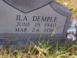

Ila Demple Crawford Parrish
| Birth | : | 19 Jun 1940 |
| Death | : | 24 Mar 2018 Hendersonville, Sumner County, Tennessee, USA |
| Burial | : | Hinson Cemetery, Moss, Clay County, USA |
| Coordinate | : | 36.5756750, -85.7020010 |
| Description | : | Ila Demple Parrish, age 77 of Hendersonville passed away peacefully on Saturday, March 24, at her home surrounded by her loving family. Demple, as she was known to her family and friends, was a member of the Luna Lane Church of Christ in Hendersonville. She enjoyed fishing, hunting Ginseng, sewing, quilting and cooking. She was preceded in death by her parents, Bertha and Rue Crawford; 3 brothers, Sonny Crawford, Dumas Crawford, Clyde Crawford; and her sister, Gladys Wilmoth. She is survived by her husband of 61 years, Joe “Danny” Parrish; her son, Joe (Ruby) Parrish, Jr.;... Read More |
frequently asked questions (FAQ):
-
Where is Ila Demple Crawford Parrish's memorial?
Ila Demple Crawford Parrish's memorial is located at: Hinson Cemetery, Moss, Clay County, USA.
-
When did Ila Demple Crawford Parrish death?
Ila Demple Crawford Parrish death on 24 Mar 2018 in Hendersonville, Sumner County, Tennessee, USA
-
Where are the coordinates of the Ila Demple Crawford Parrish's memorial?
Latitude: 36.5756750
Longitude: -85.7020010
Family Members:
Parent

Siblings
Flowers:


Nearby Cemetories:
1. Hinson Cemetery
Moss, Clay County, USA
Coordinate: 36.5756750, -85.7020010
2. Jonestown Cemetery
Clay County, USA
Coordinate: 36.5619011, -85.6921997
3. Cherry Denton Cemetery
Clay County, USA
Coordinate: 36.5512200, -85.6971200
4. Pitcock Cemetery
Clay County, USA
Coordinate: 36.5992012, -85.6911011
5. Cherry Cemetery #3
Oak Grove, Clay County, USA
Coordinate: 36.6015000, -85.7100300
6. James H. Cherry Family Cemetery
Clay County, USA
Coordinate: 36.5453700, -85.7266000
7. Smith Cemetery
Pine Hill, Clay County, USA
Coordinate: 36.5714930, -85.6568170
8. Clementsville Cemetery
Clementsville, Clay County, USA
Coordinate: 36.6132300, -85.7146410
9. Pricetown Cemetery
Clay County, USA
Coordinate: 36.5422500, -85.6750670
10. Eads-Denton Cemetery
Pine Hill, Clay County, USA
Coordinate: 36.5644207, -85.6503187
11. Mount Vernon Cemetery
Miles Crossroads, Clay County, USA
Coordinate: 36.5435982, -85.7403030
12. Liberty Church Cemetery
Boles, Clay County, USA
Coordinate: 36.6010850, -85.6496830
13. Browning Cemetery
Clay County, USA
Coordinate: 36.5578003, -85.7602997
14. Moore Cemetery #1
Moss, Clay County, USA
Coordinate: 36.6164920, -85.6636620
15. Kendall Cemetery
Moss, Clay County, USA
Coordinate: 36.5672540, -85.6362650
16. Old Bowman Cemetery
Gamaliel, Monroe County, USA
Coordinate: 36.6289830, -85.7204190
17. Beech Grove Cemetery
Harlan Crossroads, Monroe County, USA
Coordinate: 36.6319000, -85.6809000
18. Hermitage Springs Cemetery
Hermitage Springs, Clay County, USA
Coordinate: 36.5823500, -85.7750900
19. Moore Cemetery
Moss, Clay County, USA
Coordinate: 36.6113400, -85.6374980
20. Willhoite-Curtis Cemetery
Tompkinsville, Monroe County, USA
Coordinate: 36.6182208, -85.6442948
21. Moss Cemetery
Moss, Clay County, USA
Coordinate: 36.5911210, -85.6214460
22. Pedigo Cemetery
Clay County, USA
Coordinate: 36.5744019, -85.7863998
23. Beautiful Home Cemetery
Tompkinsville, Monroe County, USA
Coordinate: 36.6392000, -85.7371000
24. Old Bob Wood Place Cemetery
Boles, Monroe County, USA
Coordinate: 36.6325120, -85.6515600