

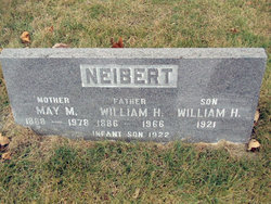
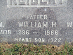
Infant Son Neibert
| Birth | : | 21 Dec 1922 |
| Death | : | 21 Dec 1922 |
| Burial | : | Elmwood Cemetery, Gooding, Gooding County, USA |
| Coordinate | : | 42.9308014, -114.7011032 |
| Plot | : | Old.P.296 |
| Description | : | Son of William Henry Neibert and May Julia McClain Neibert. Not named. |
frequently asked questions (FAQ):
-
Where is Infant Son Neibert's memorial?
Infant Son Neibert's memorial is located at: Elmwood Cemetery, Gooding, Gooding County, USA.
-
When did Infant Son Neibert death?
Infant Son Neibert death on 21 Dec 1922 in
-
Where are the coordinates of the Infant Son Neibert's memorial?
Latitude: 42.9308014
Longitude: -114.7011032
Family Members:
Parent
Siblings
Flowers:


Nearby Cemetories:
1. Elmwood Cemetery
Gooding, Gooding County, USA
Coordinate: 42.9308014, -114.7011032
2. Pioneer Cemetery
Gooding, Gooding County, USA
Coordinate: 42.9324989, -114.6931000
3. Wendell Cemetery
Wendell, Gooding County, USA
Coordinate: 42.7734160, -114.7111700
4. Hagerman Cemetery
Hagerman, Gooding County, USA
Coordinate: 42.8230500, -114.8902810
5. Pioneer Cemetery
Bliss, Gooding County, USA
Coordinate: 42.9227982, -114.9443970
6. Hagerman Pioneer Cemetery
Hagerman, Gooding County, USA
Coordinate: 42.8298000, -114.9040000
7. Bliss Family Cemetery
Bliss, Gooding County, USA
Coordinate: 42.9084900, -114.9497800
8. Upper Clover Creek Cemetery
Bliss, Gooding County, USA
Coordinate: 43.0297000, -114.9458000
9. Chinese Memorial Cemetery
Gooding County, USA
Coordinate: 42.9266000, -114.9841000
10. Shoshone Cemetery
Shoshone, Lincoln County, USA
Coordinate: 42.9388270, -114.3879960
11. Jerome Cemetery
Jerome, Jerome County, USA
Coordinate: 42.7141400, -114.5299500
12. Lower Clover Creek Cemetery
Bliss, Gooding County, USA
Coordinate: 43.0229100, -115.0456200
13. Dietrich Cemetery
Dietrich, Lincoln County, USA
Coordinate: 42.8946400, -114.2958400
14. Monastery of the Ascension Cemetery
Jerome, Jerome County, USA
Coordinate: 42.7067000, -114.4162000
15. West End Cemetery
Buhl, Twin Falls County, USA
Coordinate: 42.6008380, -114.7366730
16. Snake River Canyon National Cemetery
Buhl, Twin Falls County, USA
Coordinate: 42.6016979, -114.7586136
17. Manard Cemetery
Fairfield, Camas County, USA
Coordinate: 43.2675018, -114.7463989
18. Church of God in Christ Mennonite Cemetery
Buhl, Twin Falls County, USA
Coordinate: 42.5942000, -114.8307000
19. Barbara Ann Morgan Gravesite
Twin Falls County, USA
Coordinate: 42.5768970, -114.7119550
20. Ira Burton Perrine Cemetery
Perrine, Jerome County, USA
Coordinate: 42.6082500, -114.4754000
21. Filer Cemetery
Filer, Twin Falls County, USA
Coordinate: 42.5778008, -114.5847015
22. Valley View Mennonite Church Cemetery
Twin Falls County, USA
Coordinate: 42.5670000, -114.6745000
23. King Hill Cemetery
King Hill, Elmore County, USA
Coordinate: 42.9975610, -115.2239060
24. Ascension Episcopal Church Cemetery
Twin Falls, Twin Falls County, USA
Coordinate: 42.5680000, -114.4418000