Isabelle Hannah Carnahan Brust
| Birth | : | 24 Sep 1858 Butler County, Pennsylvania, USA |
| Death | : | 29 Feb 1928 Stella, Newton County, Missouri, USA |
| Burial | : | Santa Barbara Cemetery, Santa Barbara, Santa Barbara County, USA |
| Coordinate | : | 34.4188995, -119.6544037 |
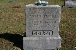
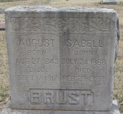
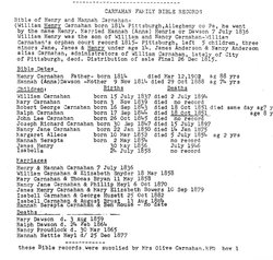
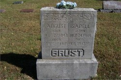
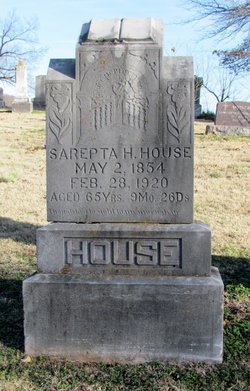
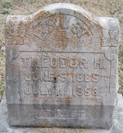
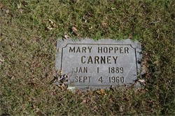
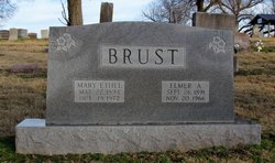
| Description | : | ISABELL BRUST DIES Mrs. Isabell Brust, mother of Theodore Brust, died at the home of her son near Christopher, Wednesday, February 29 at the age of 73. Funeral services were held Thursday and burial was made in the Hazelgreen Cemetery. The Neosho Times Thursday, Mary 8, 1928 ***~~**~~*** Wife of George K. Huyett (Marr. Oct. 25, 1882 in Douglas Co., KS.) George "August" August Brust (Marr. Aug. 13, 1884 in Douglas Co., KS. He died Sept. 17, 1917.) Mother of Theodore Henry Brust, Sarpeta Hannah (Brust) Scott Horner, Mary Belle (Brust) Hopper, Elmer August Brust, Rev. William John Brust, and George Benjamine Brust. Daughter of William... Read More |
frequently asked questions (FAQ):
-
Where is Isabelle Hannah Carnahan Brust's memorial?
Isabelle Hannah Carnahan Brust's memorial is located at: Santa Barbara Cemetery, Santa Barbara, Santa Barbara County, USA.
-
When did Isabelle Hannah Carnahan Brust death?
Isabelle Hannah Carnahan Brust death on 29 Feb 1928 in Stella, Newton County, Missouri, USA
-
Where are the coordinates of the Isabelle Hannah Carnahan Brust's memorial?
Latitude: 34.4188995
Longitude: -119.6544037
Family Members:
Parent
Spouse
Siblings
Children
Flowers:
Nearby Cemetories:
1. Santa Barbara Cemetery
Santa Barbara, Santa Barbara County, USA
Coordinate: 34.4188995, -119.6544037
2. All Saints By The Sea Episcopal Church Columbarium
Montecito, Santa Barbara County, USA
Coordinate: 34.4210500, -119.6312100
3. Presidio Cemetery
Santa Barbara, Santa Barbara County, USA
Coordinate: 34.4228790, -119.6991480
4. Montecito Cemetery
Montecito, Santa Barbara County, USA
Coordinate: 34.4363080, -119.5959850
5. Mission Santa Barbara Cemetery
Santa Barbara, Santa Barbara County, USA
Coordinate: 34.4378800, -119.7134600
6. Calvary Cemetery
Santa Barbara, Santa Barbara County, USA
Coordinate: 34.4432983, -119.7466965
7. Carpinteria Cemetery
Carpinteria, Santa Barbara County, USA
Coordinate: 34.4118996, -119.5385971
8. Potters Field Cemetery
Goleta, Santa Barbara County, USA
Coordinate: 34.4526310, -119.7686540
9. Cieneguitas Catholic Cemetery
La Patera, Santa Barbara County, USA
Coordinate: 34.4402920, -119.7744090
10. Goleta Cemetery
Goleta, Santa Barbara County, USA
Coordinate: 34.4407997, -119.7802963
11. Christ the King Episcopal Church Memorial Garden
Santa Barbara, Santa Barbara County, USA
Coordinate: 34.4343418, -119.7998439
12. Ferrer Family Ranch Grounds
Carpinteria, Santa Barbara County, USA
Coordinate: 34.3821940, -119.4812560
13. Ojai United Methodist Memorial Garden
Ojai, Ventura County, USA
Coordinate: 34.4437040, -119.2665540
14. Saint Thomas Aquinas Cemetery
Ojai, Ventura County, USA
Coordinate: 34.4301250, -119.2650250
15. Mission San Buenaventura Cemetery
Ventura, Ventura County, USA
Coordinate: 34.2811890, -119.2982090
16. Nordhoff Cemetery
Ojai, Ventura County, USA
Coordinate: 34.4446600, -119.2604400
17. Ojai Presbyterian Church Columbarium
Ojai, Ventura County, USA
Coordinate: 34.4494250, -119.2530420
18. Saint Andrews Episcopal Church Columbarium
Ojai, Ventura County, USA
Coordinate: 34.4454300, -119.2513700
19. First United Methodist Church Ventura Columbarium
Ventura, Ventura County, USA
Coordinate: 34.2793589, -119.2819936
20. Cemetery Memorial Park
Ventura, Ventura County, USA
Coordinate: 34.2811900, -119.2800700
21. Saint Pauls Episcopal Church Memorial Garden
Ventura, Ventura County, USA
Coordinate: 34.2759070, -119.2522820
22. Rancho del Cielo Cemetery
Santa Barbara, Santa Barbara County, USA
Coordinate: 34.5304780, -120.0758920
23. Trinity Lutheran Church Columbarium
Ventura, Ventura County, USA
Coordinate: 34.2772220, -119.2394440
24. Capuchin Cemetery
Santa Ynez, Santa Barbara County, USA
Coordinate: 34.6442860, -120.0270440

