
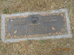
Iva Lee Greene Sprouse
| Birth | : | 7 Apr 1915 Pacolet, Spartanburg County, South Carolina, USA |
| Death | : | 8 Jun 2005 Spartanburg, Spartanburg County, South Carolina, USA |
| Burial | : | Holy Trinity Churchyard, Hoghton, Chorley Borough, England |
| Coordinate | : | 53.7279300, -2.5848550 |
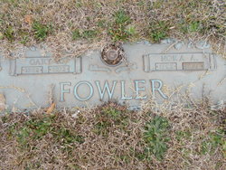
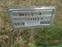
| Description | : | Iva Lee (Greene) Sprouse, 90, of Pacolet, SC, died Wednesday, June 8, 2005, at White Oak Manor of Spartanburg. Born April 7, 1915, in Pacolet, she was the daughter of the late Robert H. Greene and Nora Alvie (Gilliland) Greene Fowler and the wife of the late Thomas Albert Sprouse. Retired from Pacolet Manufacturing Company after 43 years of service, she was a member of Pacolet First Baptist Church. Survivors include three daughters, Hazel Suttles of Pacolet, Mary Sue Smith of Abbottstown, PA, and Annette Erwin of Union; two sons, Thomas Lee Sprouse of Belvedere, SC, and Floyd W. Sprouse of Glendale;... Read More |
frequently asked questions (FAQ):
-
Where is Iva Lee Greene Sprouse's memorial?
Iva Lee Greene Sprouse's memorial is located at: Holy Trinity Churchyard, Hoghton, Chorley Borough, England.
-
When did Iva Lee Greene Sprouse death?
Iva Lee Greene Sprouse death on 8 Jun 2005 in Spartanburg, Spartanburg County, South Carolina, USA
-
Where are the coordinates of the Iva Lee Greene Sprouse's memorial?
Latitude: 53.7279300
Longitude: -2.5848550
Family Members:
Parent
Spouse

Children

Flowers:


Nearby Cemetories:
1. Holy Trinity Churchyard
Hoghton, Chorley Borough, England
Coordinate: 53.7279300, -2.5848550
2. St. Josephs Roman Catholic Churchyard
Brindle, Chorley Borough, England
Coordinate: 53.7350780, -2.5880640
3. St James's Churchyard
Brindle, Chorley Borough, England
Coordinate: 53.7133333, -2.6086111
4. Pleasington Priory
Pleasington, Blackburn with Darwen Unitary Authority, England
Coordinate: 53.7348590, -2.5433060
5. Pleasington Cemetery and Crematorium
Blackburn, Blackburn with Darwen Unitary Authority, England
Coordinate: 53.7388880, -2.5368710
6. St Paul's Churchyard
Withnell, Chorley Borough, England
Coordinate: 53.6970740, -2.5592150
7. All Saints Churchyard
Walton-le-Dale, South Ribble Borough, England
Coordinate: 53.7407250, -2.6408280
8. Our Lady and St Patrick's Church
Walton-le-Dale, South Ribble Borough, England
Coordinate: 53.7407250, -2.6408280
9. St. Bedes Churchyard
Clayton-le-Woods, Chorley Borough, England
Coordinate: 53.7079260, -2.6390320
10. St. Mary's and St. John RC Churchyard, Southworth
Samlesbury, South Ribble Borough, England
Coordinate: 53.7676690, -2.6183400
11. St. Saviour's Churchyard
Bamber Bridge, South Ribble Borough, England
Coordinate: 53.7197301, -2.6598985
12. St Stephen Churchyard
Tockholes, Blackburn with Darwen Unitary Authority, England
Coordinate: 53.7058350, -2.5169320
13. St. Leonard the Less Churchyard
Samlesbury, South Ribble Borough, England
Coordinate: 53.7680000, -2.6237000
14. St. Chad's South Hill Churchyard
Wheelton, Chorley Borough, England
Coordinate: 53.6826040, -2.6125010
15. St Mary's Churchyard Brownedge
Bamber Bridge, South Ribble Borough, England
Coordinate: 53.7305472, -2.6669416
16. New Row Methodist Church
Blackburn with Darwen Unitary Authority, England
Coordinate: 53.7208950, -2.5023720
17. St Barnabas Churchyard
Heapey, Chorley Borough, England
Coordinate: 53.6792520, -2.6043310
18. St John the Evangelist Churchyard
Whittle-le-Woods, Chorley Borough, England
Coordinate: 53.6883280, -2.6400320
19. St Leonard Churchyard
Walton-le-Dale, South Ribble Borough, England
Coordinate: 53.7476530, -2.6666950
20. St. Mary's Churchyard
Mellor, Ribble Valley Borough, England
Coordinate: 53.7728600, -2.5312400
21. Mellor Methodist Churchyard
Blackburn, Blackburn with Darwen Unitary Authority, England
Coordinate: 53.7742950, -2.5255060
22. St Leonard Churchyard
Balderstone, Ribble Valley Borough, England
Coordinate: 53.7860070, -2.5609380
23. St Paul's
Blackburn, Blackburn with Darwen Unitary Authority, England
Coordinate: 53.7491222, -2.4891266
24. St. Peter's Churchyard
Blackburn, Blackburn with Darwen Unitary Authority, England
Coordinate: 53.7448110, -2.4865070