
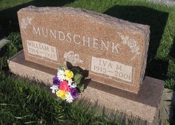
Iva Margaret Haas Mundschenk
| Birth | : | 28 Sep 1915 Boone County, Nebraska, USA |
| Death | : | 18 Feb 2001 Albion, Boone County, Nebraska, USA |
| Burial | : | St. Mary's Churchyard, Tarleton, West Lancashire District, England |
| Coordinate | : | 53.6746100, -2.8239200 |
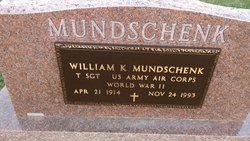
| Description | : | Daughter of Otto & Theresa (Franzen) Haas. Married to William "Bill" K. Mundschenk on 6-18-1946 at Albion, Ne. |
frequently asked questions (FAQ):
-
Where is Iva Margaret Haas Mundschenk's memorial?
Iva Margaret Haas Mundschenk's memorial is located at: St. Mary's Churchyard, Tarleton, West Lancashire District, England.
-
When did Iva Margaret Haas Mundschenk death?
Iva Margaret Haas Mundschenk death on 18 Feb 2001 in Albion, Boone County, Nebraska, USA
-
Where are the coordinates of the Iva Margaret Haas Mundschenk's memorial?
Latitude: 53.6746100
Longitude: -2.8239200
Family Members:
Parent

Spouse
Flowers:


Nearby Cemetories:
1. St. Mary's Churchyard
Tarleton, West Lancashire District, England
Coordinate: 53.6746100, -2.8239200
2. Congregational Church
Bretherton, Chorley Borough, England
Coordinate: 53.6780260, -2.7986920
3. St. John the Baptist Churchyard
Bretherton, Chorley Borough, England
Coordinate: 53.6776300, -2.7952200
4. St. Michael and All Angel Churchyard
Much Hoole, South Ribble Borough, England
Coordinate: 53.6942950, -2.8143830
5. Becconsall Old Church Churchyard
Hesketh with Becconsall, West Lancashire District, England
Coordinate: 53.7023610, -2.8314810
6. Woodland Burial Ground
Much Hoole, South Ribble Borough, England
Coordinate: 53.6986390, -2.7974440
7. All Saints Churchyard
Hesketh with Becconsall, West Lancashire District, England
Coordinate: 53.7028189, -2.8400142
8. Croston Cemetery
Croston, Chorley Borough, England
Coordinate: 53.6586700, -2.7733100
9. Much Hoole Methodist Burial Ground
Much Hoole, South Ribble Borough, England
Coordinate: 53.7053750, -2.7951470
10. St. Mary the Virgin Churchyard
Rufford, West Lancashire District, England
Coordinate: 53.6349960, -2.8126410
11. Saint James Churchyard
Leyland, South Ribble Borough, England
Coordinate: 53.6896630, -2.7327430
12. St. Andrew's Churchyard
Longton, South Ribble Borough, England
Coordinate: 53.7263889, -2.7822222
13. St Mary the Virgin Churchyard
Eccleston, Chorley Borough, England
Coordinate: 53.6528800, -2.7331920
14. St. Peter's Churchyard
Mawdesley, Chorley Borough, England
Coordinate: 53.6237600, -2.7734100
15. St. Stephen's Churchyard
North Meols, West Lancashire District, England
Coordinate: 53.6813720, -2.9248140
16. St. Peter and St. Paul Churchyard
Mawdesley, Chorley Borough, England
Coordinate: 53.6266580, -2.7451420
17. St John the Baptist Churchyard
Burscough, West Lancashire District, England
Coordinate: 53.6042760, -2.8401390
18. Saint John Crossens Churchyard
Crossens, Metropolitan Borough of Sefton, England
Coordinate: 53.6733410, -2.9478740
19. St Mary's Roman Catholic Churchyard
Leyland, South Ribble Borough, England
Coordinate: 53.6880510, -2.6983240
20. Saint Andrews Churchyard
Leyland, South Ribble Borough, England
Coordinate: 53.6881270, -2.6957880
21. St Cuthberts Churchyard
Southport, Metropolitan Borough of Sefton, England
Coordinate: 53.6603230, -2.9620310
22. Holy Trinity Churchyard
Freckleton, Fylde Borough, England
Coordinate: 53.7543090, -2.8669130
23. St. Elizabeth's Churchyard
Scarisbrick, West Lancashire District, England
Coordinate: 53.6124460, -2.9206340
24. St John The Evangelist Roman Catholic Church
Burscough, West Lancashire District, England
Coordinate: 53.5902152, -2.8424163