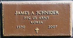
James Anthony Schnider
| Birth | : | 6 Apr 1930 Salem, McCook County, South Dakota, USA |
| Death | : | 23 Sep 2007 Sioux Falls, Minnehaha County, South Dakota, USA |
| Burial | : | Sacramento County Veterans Memorial Cemetery, Sacramento, Sacramento County, USA |
| Coordinate | : | 38.5252838, -121.4239120 |
| Description | : | Funeral Mass will be Thurs., Sept. 27, for James Anthony Schnider, 77, Sioux Falls, who died unexpectedly on Sept. 23, 2007, at Avera McKennan Hospital. The Rev. Charles Cimpl will officiate in St. Michael Catholic Church at Sioux Falls, and burial with military honors will be in St. Mary Cemetery at Salem. Schnider was born on April 6, 1930, at Salem. He grew up in Salem and graduated from St. Mary High School in 1948. He attended Worthington Junior College and coached at St. Mary High School for two years. He served in the U.S. Army during the Korean War. He... Read More |
frequently asked questions (FAQ):
-
Where is James Anthony Schnider's memorial?
James Anthony Schnider's memorial is located at: Sacramento County Veterans Memorial Cemetery, Sacramento, Sacramento County, USA.
-
When did James Anthony Schnider death?
James Anthony Schnider death on 23 Sep 2007 in Sioux Falls, Minnehaha County, South Dakota, USA
-
Where are the coordinates of the James Anthony Schnider's memorial?
Latitude: 38.5252838
Longitude: -121.4239120
Family Members:
Parent
Spouse
Siblings
Children
Flowers:
Nearby Cemetories:
1. Sacramento County Veterans Memorial Cemetery
Sacramento, Sacramento County, USA
Coordinate: 38.5252838, -121.4239120
2. Sacramento County Cemetery
Sacramento County, USA
Coordinate: 38.5267900, -121.4233700
3. Russian Orthodox Cemetery
Sacramento, Sacramento County, USA
Coordinate: 38.5268800, -121.4244300
4. Sacramento County Hospital Cemetery
Sacramento, Sacramento County, USA
Coordinate: 38.5289300, -121.4239100
5. Saint Mary's Catholic Cemetery and Mausoleum
Sacramento, Sacramento County, USA
Coordinate: 38.5298900, -121.4261200
6. Tinh Xa Ngoc An Temple Columbarium
Sacramento, Sacramento County, USA
Coordinate: 38.5190200, -121.4159500
7. Elder Creek Cemetery
Florin, Sacramento County, USA
Coordinate: 38.5111008, -121.4169006
8. Sacramento Memorial Lawn Cemetery
Sacramento, Sacramento County, USA
Coordinate: 38.5146484, -121.4380341
9. Home of Peace Cemetery
Sacramento, Sacramento County, USA
Coordinate: 38.5137558, -121.4382782
10. Saint Rose Cemetery (Defunct)
Sacramento, Sacramento County, USA
Coordinate: 38.5208015, -121.4672012
11. East Lawn Memorial Park
Sacramento, Sacramento County, USA
Coordinate: 38.5612960, -121.4492760
12. Pho Minh Temple Columbarium
Sacramento, Sacramento County, USA
Coordinate: 38.5340100, -121.4769000
13. Saint Joseph Cemetery
Sacramento, Sacramento County, USA
Coordinate: 38.5574989, -121.4835968
14. New Helvetia Cemetery (Defunct)
Sacramento, Sacramento County, USA
Coordinate: 38.5731600, -121.4639900
15. Trinity Episcopal Cathedral Columbarium
Sacramento, Sacramento County, USA
Coordinate: 38.5705500, -121.4723770
16. Odd Fellows Lawn Cemetery and Mausoleum
Sacramento, Sacramento County, USA
Coordinate: 38.5585000, -121.5011000
17. Buddhist Church of Sacramento Nokotsudo
Sacramento, Sacramento County, USA
Coordinate: 38.5639300, -121.4978400
18. Masonic Lawn Cemetery
Sacramento, Sacramento County, USA
Coordinate: 38.5604720, -121.5032600
19. Sacramento City Cemetery
Sacramento, Sacramento County, USA
Coordinate: 38.5636864, -121.5009537
20. Sunset Hill Cemetery
Sacramento, Sacramento County, USA
Coordinate: 38.5608000, -121.5037300
21. California State Capitol
Sacramento, Sacramento County, USA
Coordinate: 38.5760994, -121.4931488
22. National Shrine of Our Lady of Guadalupe Crypt
Sacramento, Sacramento County, USA
Coordinate: 38.5704800, -121.5014400
23. Bellview Cemetery
Sacramento, Sacramento County, USA
Coordinate: 38.5153580, -121.3257446
24. Sacramento Pet Cemetery
Sacramento, Sacramento County, USA
Coordinate: 38.4815870, -121.3402080


