

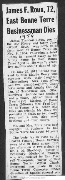
James Francois Roux
| Birth | : | 6 Nov 1884 Bonne Terre, St. Francois County, Missouri, USA |
| Death | : | 17 Apr 1956 East Bonne Terre, St. Francois County, Missouri, USA |
| Burial | : | Fairview Cemetery, Smith Center, Smith County, USA |
| Coordinate | : | 39.7966995, -98.7881012 |
| Description | : | Husband of Maud Berry Son of Henry Roux & Mary Jane Whitt |
frequently asked questions (FAQ):
-
Where is James Francois Roux's memorial?
James Francois Roux's memorial is located at: Fairview Cemetery, Smith Center, Smith County, USA.
-
When did James Francois Roux death?
James Francois Roux death on 17 Apr 1956 in East Bonne Terre, St. Francois County, Missouri, USA
-
Where are the coordinates of the James Francois Roux's memorial?
Latitude: 39.7966995
Longitude: -98.7881012
Family Members:
Parent
Spouse
Siblings

Children
Flowers:


Nearby Cemetories:
1. Fairview Cemetery
Smith Center, Smith County, USA
Coordinate: 39.7966995, -98.7881012
2. Pleasant View Cemetery
Athol, Smith County, USA
Coordinate: 39.7859000, -98.8982000
3. Meade Cemetery
Reamsville, Smith County, USA
Coordinate: 39.8680992, -98.8839035
4. Saint John Lutheran Cemetery
Athol, Smith County, USA
Coordinate: 39.7269900, -98.8971600
5. Zion Cemetery
Athol, Smith County, USA
Coordinate: 39.8434100, -98.9171700
6. William Nelson Gravesite
Athol, Smith County, USA
Coordinate: 39.8866080, -98.8708130
7. Christ Cemetery
Gaylord, Smith County, USA
Coordinate: 39.6988100, -98.8556700
8. Custer Cemetery
Bellaire, Smith County, USA
Coordinate: 39.7350115, -98.6545141
9. Spring Vale Cemetery
Washington Township, Smith County, USA
Coordinate: 39.9154700, -98.7424900
10. Cedar Hill Cemetery
Cora, Smith County, USA
Coordinate: 39.8863200, -98.6550000
11. Crystal Plains Cemetery
Smith Center, Smith County, USA
Coordinate: 39.6909714, -98.6730270
12. Oak Hill Cemetery
Lebanon, Smith County, USA
Coordinate: 39.8437010, -98.6186200
13. Gaylord Cemetery
Gaylord, Smith County, USA
Coordinate: 39.6598300, -98.8416700
14. Parse Homestead Cemetery
Bellaire, Smith County, USA
Coordinate: 39.7269800, -98.6245300
15. Price Cemetery
Oak Township, Smith County, USA
Coordinate: 39.7986860, -98.5993060
16. Eminence Cemetery
Thornburg, Smith County, USA
Coordinate: 39.9432983, -98.8005981
17. Reamsville Methodist Church Cemetery
Reamsville, Smith County, USA
Coordinate: 39.9299500, -98.8693970
18. Reamsville Cemetery
Reamsville, Smith County, USA
Coordinate: 39.9441500, -98.8593500
19. Bell Cemetery
Smith Center, Smith County, USA
Coordinate: 39.6477700, -98.7102200
20. Cedar Cemetery
Cedar, Smith County, USA
Coordinate: 39.6685982, -98.9310989
21. Old Harlan Cemetery
Harlan, Smith County, USA
Coordinate: 39.6153520, -98.7632390
22. Pleasant Hill Cemetery
Reamsville, Smith County, USA
Coordinate: 39.9510994, -98.9175034
23. Sweet Home Cemetery
Lebanon, Smith County, USA
Coordinate: 39.7854830, -98.5465380
24. Womer Cemetery
Womer, Smith County, USA
Coordinate: 39.9736400, -98.7110800