
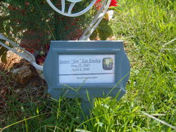
James Lee “Jim” Ensley
| Birth | : | 22 May 1942 Fayetteville, Washington County, Arkansas, USA |
| Death | : | 4 Apr 2008 Shell Knob, Barry County, Missouri, USA |
| Burial | : | Westview Cemetery, Carrollton, Carroll County, USA |
| Coordinate | : | 40.5663986, -81.0852966 |
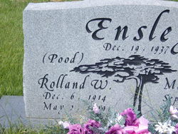
| Description | : | The Morning News April 7, 2008 FAYETTEVILLE -- James "Jim" Lee Ensley, 66, of Fayetteville died April 4, 2008, in Shell Knob, Mo. He was born May 22, 1942, in Fayetteville to Roland and Jane Harrison Ensley. He was a lifetime resident of this area and was a member of the Elks Club and Moose Lodge. He was of the Church of Christ faith. Survivors include his wife, Gwen, of the home; two sons, James Easley Jr. of Manhattan, N.Y., Dean Easley of Springdale; one sister, Jan Ensley of Springdale; two Stepchildren, Helen Irven of Springdale, Phillip Yingst of Stilwell, Okla.; six grandchildren;... Read More |
frequently asked questions (FAQ):
-
Where is James Lee “Jim” Ensley's memorial?
James Lee “Jim” Ensley's memorial is located at: Westview Cemetery, Carrollton, Carroll County, USA.
-
When did James Lee “Jim” Ensley death?
James Lee “Jim” Ensley death on 4 Apr 2008 in Shell Knob, Barry County, Missouri, USA
-
Where are the coordinates of the James Lee “Jim” Ensley's memorial?
Latitude: 40.5663986
Longitude: -81.0852966
Family Members:
Parent
Spouse

Flowers:


Nearby Cemetories:
1. Westview Cemetery
Carrollton, Carroll County, USA
Coordinate: 40.5663986, -81.0852966
2. Grandview Cemetery
Carrollton, Carroll County, USA
Coordinate: 40.5694008, -81.0828018
3. Immaculate Heart of Mary Cemetery
Carrollton, Carroll County, USA
Coordinate: 40.5758010, -81.0955510
4. Aller Family Cemetery
Carrollton, Carroll County, USA
Coordinate: 40.5879760, -81.0771540
5. Champers Cemetery
Carrollton, Carroll County, USA
Coordinate: 40.5667610, -81.1178540
6. Piecynski Farm Cemetery
Carrollton, Carroll County, USA
Coordinate: 40.5658690, -81.1224020
7. Mount Pleasant Cemetery
Carrollton, Carroll County, USA
Coordinate: 40.5238991, -81.1003036
8. Lee Cemetery
Carroll County, USA
Coordinate: 40.5391998, -81.0314026
9. Pleasant Valley Cemetery
Carroll County, USA
Coordinate: 40.5764008, -81.1493988
10. Wherry Cemetery
Stemple, Carroll County, USA
Coordinate: 40.6156006, -81.1063995
11. Denver George Haddock Family Cemetery
Carrollton, Carroll County, USA
Coordinate: 40.5443880, -81.0227370
12. County Home Cemetery
Carroll County, USA
Coordinate: 40.6175003, -81.0674973
13. Old Scott Cemetery
Carroll County, USA
Coordinate: 40.5483017, -81.1541977
14. McGuire Cemetery
Tabor, Carroll County, USA
Coordinate: 40.5518990, -81.1564026
15. Seceders Cemetery
Carroll County, USA
Coordinate: 40.5332985, -81.1446991
16. Downing Cemetery
Carroll County, USA
Coordinate: 40.5567017, -81.0117035
17. Green Hill Cemetery
Carroll County, USA
Coordinate: 40.5303001, -81.0246964
18. Scotts Cemetery
Carroll County, USA
Coordinate: 40.5386009, -81.1556015
19. Farnsworth Cemetery
Carroll County, USA
Coordinate: 40.5385017, -81.1567001
20. Mount Olivet Cemetery
Carroll County, USA
Coordinate: 40.5905991, -81.0081024
21. Moorehead Cemetery
Carroll County, USA
Coordinate: 40.5449982, -81.0033035
22. Stuller Cemetery
Carroll County, USA
Coordinate: 40.6302986, -81.0513992
23. New Harrisburg Cemetery
New Harrisburg, Carroll County, USA
Coordinate: 40.6208000, -81.1483002
24. Harsh-Swamp Cemetery
Carroll County, USA
Coordinate: 40.6413994, -81.0892029