
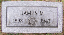
James M Crum
| Birth | : | 1892 Missouri, USA |
| Death | : | 1947 Leavenworth, Leavenworth County, Kansas, USA |
| Burial | : | Olean Cemetery, Olean, Miller County, USA |
| Coordinate | : | 38.4131012, -92.5413971 |
| Description | : | The Eldon Advertiser, January 9, 1947 Funeral services for James M Crum, a former banker at Eugene, were held at Eugene Monday afternoon with burial in the Olean Cemetery under the direction of Phillips Funeral Service with Rev. A.L. Alexander officiating. Mr. Crum suffered a stroke 6 weeks ago at Leavenworth, Kansas, where he has been employed for the past two years by the Kansas City Star. Death occurred Friday in the Leavenworth hospital and the body was brought to Eldon Saturday. Mr. Crum, who was 54 years old, was the son of the late Judge and Mrs. S/G.... Read More |
frequently asked questions (FAQ):
-
Where is James M Crum's memorial?
James M Crum's memorial is located at: Olean Cemetery, Olean, Miller County, USA.
-
When did James M Crum death?
James M Crum death on 1947 in Leavenworth, Leavenworth County, Kansas, USA
-
Where are the coordinates of the James M Crum's memorial?
Latitude: 38.4131012
Longitude: -92.5413971
Family Members:
Parent
Spouse
Siblings
Flowers:


Nearby Cemetories:
1. Olean Cemetery
Olean, Miller County, USA
Coordinate: 38.4131012, -92.5413971
2. Green Ridge Baptist Church Cemetery
Eldon, Miller County, USA
Coordinate: 38.4116200, -92.5645700
3. Etter-Walker Cemetery
Burris Fork, Moniteau County, USA
Coordinate: 38.4333700, -92.5525400
4. Walker Cemetery
Moniteau County, USA
Coordinate: 38.4338989, -92.5522003
5. Farris Cemetery
Moniteau County, USA
Coordinate: 38.4369900, -92.5380000
6. Allen Cemetery
Olean, Miller County, USA
Coordinate: 38.4150009, -92.5008011
7. Jackson Chapel Methodist Church Cemetery
California, Moniteau County, USA
Coordinate: 38.4447900, -92.5286500
8. Gray Cemetery
Moniteau County, USA
Coordinate: 38.4536018, -92.5456009
9. Hite Cemetery
Miller County, USA
Coordinate: 38.4039001, -92.5935974
10. Mount Pleasant Cemetery
Eldon, Miller County, USA
Coordinate: 38.3667700, -92.5300800
11. Salem Cemetery
Saline Township, Miller County, USA
Coordinate: 38.3691232, -92.5697260
12. Salem Cemetery
Eldon, Miller County, USA
Coordinate: 38.3697014, -92.5714035
13. Mount Vernon Cemetery
Eldon, Miller County, USA
Coordinate: 38.3624992, -92.5606003
14. Bruce-Lewis-McGahan Cemetery
Enon, Moniteau County, USA
Coordinate: 38.4667500, -92.5172100
15. Rock Enon Cemetery
Miller County, USA
Coordinate: 38.4668400, -92.5170700
16. Eldon Cemetery
Eldon, Miller County, USA
Coordinate: 38.3642006, -92.5868988
17. Phillips Cemetery
High Point, Moniteau County, USA
Coordinate: 38.4430300, -92.6125300
18. Colburn Cemetery
Eldon, Miller County, USA
Coordinate: 38.4246300, -92.6275500
19. Depp Cemetery
High Point, Moniteau County, USA
Coordinate: 38.4776400, -92.5818500
20. High Point Cemetery
High Point, Moniteau County, USA
Coordinate: 38.4817009, -92.5757980
21. Phillips Cemetery
Barnett, Morgan County, USA
Coordinate: 38.4227982, -92.6367035
22. Matheis Cemetery
Russellville, Cole County, USA
Coordinate: 38.4571800, -92.4491600
23. United Baptist Church Cemetery
High Point, Moniteau County, USA
Coordinate: 38.4962200, -92.5856800
24. Karnes-Carney-Henderson Cemetery
Burris Fork, Moniteau County, USA
Coordinate: 38.4992100, -92.5007510