
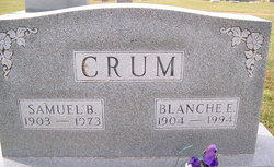
Samuel Bryan Crum
| Birth | : | 11 Feb 1903 Olean, Miller County, Missouri, USA |
| Death | : | 25 Jul 1973 Columbia, Boone County, Missouri, USA |
| Burial | : | Olean Cemetery, Olean, Miller County, USA |
| Coordinate | : | 38.4131012, -92.5413971 |
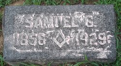
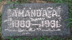
| Description | : | Daily Capital News, Friday, July 27, 1973, Jefferson City, Missouri Samuel Bryan Crum, 70, of Olean, died Wednesday at University of Missouri Medical Center, Columbia. Mr. Crum was born Feb. 11, 1903, near Olean, the son of Samuel G. and Amanda Howard Crum. On Feb. 20, 1923 he was married at California to the former Miss Blanche E. Renken, who survives. Other survivors include: a foster-daughter, Mrs. Helen Mae Vittur, Ft. Lauderdale, Fla. Funeral services will be at 2 p.m. Saturday, at the Phillips Funeral Chapel, Eldon, with the Rev. Gilbert Pearson officiating. Burial will be in the... Read More |
frequently asked questions (FAQ):
-
Where is Samuel Bryan Crum's memorial?
Samuel Bryan Crum's memorial is located at: Olean Cemetery, Olean, Miller County, USA.
-
When did Samuel Bryan Crum death?
Samuel Bryan Crum death on 25 Jul 1973 in Columbia, Boone County, Missouri, USA
-
Where are the coordinates of the Samuel Bryan Crum's memorial?
Latitude: 38.4131012
Longitude: -92.5413971
Family Members:
Parent
Spouse

Siblings
Flowers:


Nearby Cemetories:
1. Olean Cemetery
Olean, Miller County, USA
Coordinate: 38.4131012, -92.5413971
2. Green Ridge Baptist Church Cemetery
Eldon, Miller County, USA
Coordinate: 38.4116200, -92.5645700
3. Etter-Walker Cemetery
Burris Fork, Moniteau County, USA
Coordinate: 38.4333700, -92.5525400
4. Walker Cemetery
Moniteau County, USA
Coordinate: 38.4338989, -92.5522003
5. Farris Cemetery
Moniteau County, USA
Coordinate: 38.4369900, -92.5380000
6. Allen Cemetery
Olean, Miller County, USA
Coordinate: 38.4150009, -92.5008011
7. Jackson Chapel Methodist Church Cemetery
California, Moniteau County, USA
Coordinate: 38.4447900, -92.5286500
8. Gray Cemetery
Moniteau County, USA
Coordinate: 38.4536018, -92.5456009
9. Hite Cemetery
Miller County, USA
Coordinate: 38.4039001, -92.5935974
10. Mount Pleasant Cemetery
Eldon, Miller County, USA
Coordinate: 38.3667700, -92.5300800
11. Salem Cemetery
Saline Township, Miller County, USA
Coordinate: 38.3691232, -92.5697260
12. Salem Cemetery
Eldon, Miller County, USA
Coordinate: 38.3697014, -92.5714035
13. Mount Vernon Cemetery
Eldon, Miller County, USA
Coordinate: 38.3624992, -92.5606003
14. Bruce-Lewis-McGahan Cemetery
Enon, Moniteau County, USA
Coordinate: 38.4667500, -92.5172100
15. Rock Enon Cemetery
Miller County, USA
Coordinate: 38.4668400, -92.5170700
16. Eldon Cemetery
Eldon, Miller County, USA
Coordinate: 38.3642006, -92.5868988
17. Phillips Cemetery
High Point, Moniteau County, USA
Coordinate: 38.4430300, -92.6125300
18. Colburn Cemetery
Eldon, Miller County, USA
Coordinate: 38.4246300, -92.6275500
19. Depp Cemetery
High Point, Moniteau County, USA
Coordinate: 38.4776400, -92.5818500
20. High Point Cemetery
High Point, Moniteau County, USA
Coordinate: 38.4817009, -92.5757980
21. Phillips Cemetery
Barnett, Morgan County, USA
Coordinate: 38.4227982, -92.6367035
22. Matheis Cemetery
Russellville, Cole County, USA
Coordinate: 38.4571800, -92.4491600
23. United Baptist Church Cemetery
High Point, Moniteau County, USA
Coordinate: 38.4962200, -92.5856800
24. Karnes-Carney-Henderson Cemetery
Burris Fork, Moniteau County, USA
Coordinate: 38.4992100, -92.5007510