
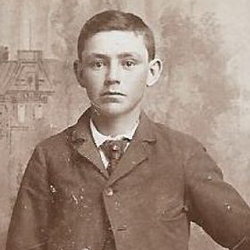
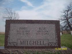
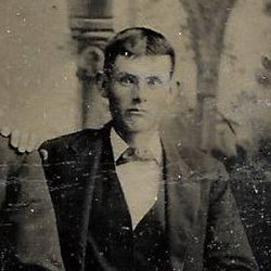
James Mitchell
| Birth | : | 22 Aug 1882 Green, Clay County, Kansas, USA |
| Death | : | 13 Jan 1965 Green, Clay County, Kansas, USA |
| Burial | : | Green Cemetery, Green, Clay County, USA |
| Coordinate | : | 39.4235992, -96.9882965 |
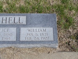
| Inscription | : | MITCHELL James Aug. 22, 1882 Jan. 13, 1965 Elsie Apr. 15, 1891 Nov. 10, 1952 |
frequently asked questions (FAQ):
-
Where is James Mitchell's memorial?
James Mitchell's memorial is located at: Green Cemetery, Green, Clay County, USA.
-
When did James Mitchell death?
James Mitchell death on 13 Jan 1965 in Green, Clay County, Kansas, USA
-
Where are the coordinates of the James Mitchell's memorial?
Latitude: 39.4235992
Longitude: -96.9882965
Family Members:
Parent
Spouse

Siblings
Children

Flowers:


Nearby Cemetories:
1. Green Cemetery
Green, Clay County, USA
Coordinate: 39.4235992, -96.9882965
2. Ebenezer Cemetery
Green, Clay County, USA
Coordinate: 39.3866997, -96.9974976
3. Pleasant Hill Cemetery
Leonardville, Riley County, USA
Coordinate: 39.4371210, -96.9426730
4. Lasita Cemetery
Leonardville, Riley County, USA
Coordinate: 39.4092900, -96.9422900
5. Fancy Creek Cemetery
Green, Clay County, USA
Coordinate: 39.4668999, -96.9969025
6. Brethren in Christ Cemetery
Clay County, USA
Coordinate: 39.4810982, -97.0344009
7. Hayes Cemetery
Clay County, USA
Coordinate: 39.4516983, -97.0811005
8. Clay County Poor Farm Cemetery
Clay Center, Clay County, USA
Coordinate: 39.3772700, -97.0727000
9. May Day Cemetery
Center Township, Riley County, USA
Coordinate: 39.4958000, -96.9302979
10. Goshen Central Cemetery
Clay Center, Clay County, USA
Coordinate: 39.5099983, -97.0160980
11. Joseph Sender Family Cemetery
Clay County, USA
Coordinate: 39.5090600, -97.0348800
12. Appleton Cemetery
Clay County, USA
Coordinate: 39.5250015, -96.9972000
13. Broughton Cemetery
Clay Center, Clay County, USA
Coordinate: 39.3306007, -97.0535965
14. Saint Peter and Saint Pauls Catholic Cemetery
Clay Center, Clay County, USA
Coordinate: 39.4005450, -97.1236680
15. Idylwilde Cemetery
Clay Center, Clay County, USA
Coordinate: 39.5097900, -97.0713000
16. Crooked Creek Cemetery
Randolph, Riley County, USA
Coordinate: 39.4369011, -96.8480988
17. Leonardville Cemetery
Leonardville, Riley County, USA
Coordinate: 39.3792000, -96.8589020
18. Greenwood Cemetery
Clay Center, Clay County, USA
Coordinate: 39.4011002, -97.1275024
19. Swedish Pleasant Hill Cemetery
Clay Center, Clay County, USA
Coordinate: 39.4735985, -97.1268997
20. Saint Johns Lutheran Cemetery
Winkler, Riley County, USA
Coordinate: 39.4813995, -96.8494034
21. Bala Cemetery
Bala, Riley County, USA
Coordinate: 39.3053017, -96.9341965
22. Leonardville United Methodist Cemetery
Leonardville, Riley County, USA
Coordinate: 39.3568700, -96.8493600
23. Walsburg Lutheran Cemetery
Leonardville, Riley County, USA
Coordinate: 39.3931100, -96.8133200
24. Swedish Evangelical Lutheran Cemetery
Clay County, USA
Coordinate: 39.4911700, -97.1455100