
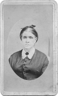

Mary Amanda “Polly” Roberts Mitchell
| Birth | : | 1 Apr 1842 Grant County, Indiana, USA |
| Death | : | 19 Oct 1930 Linn, Washington County, Kansas, USA |
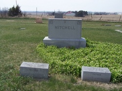
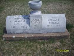
| Burial | : | Green Cemetery, Green, Clay County, USA |
| Coordinate | : | 39.4235992, -96.9882965 |
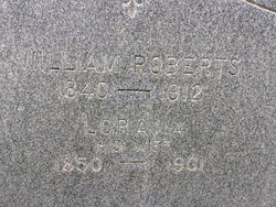
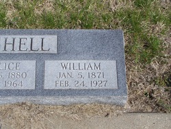
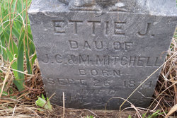
| Inscription | : | Mary Apr. 1, 1842 Oct. 19, 1930 Mother |
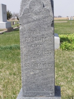
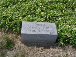
| Description | : | The Times Clay Center, Kansas, 23 October, 1930, Section 2, Page 1, Col. 4 Mitchell-Mrs. Mary Mitchell, one of the oldest settlers of the Green neighborhood, and one of the best known and best liked ladies of the community, passed away Sunday morning, October 19th, at the home of her daughter, Mrs. Terry, near Linn, Washington county. The story of Mrs. Mitchell's life is as below: Mrs. Mary Mitchell was the oldest daughter of Paul and Mary Roberts, born in Grant County, Indiana, April 1st., 1842. Her girlhood and young womanhood was spent in the Hoosier State. She was married to John C. Mitchell... Read More |
frequently asked questions (FAQ):
-
Where is Mary Amanda “Polly” Roberts Mitchell's memorial?
Mary Amanda “Polly” Roberts Mitchell's memorial is located at: Green Cemetery, Green, Clay County, USA.
-
When did Mary Amanda “Polly” Roberts Mitchell death?
Mary Amanda “Polly” Roberts Mitchell death on 19 Oct 1930 in Linn, Washington County, Kansas, USA
-
Where are the coordinates of the Mary Amanda “Polly” Roberts Mitchell's memorial?
Latitude: 39.4235992
Longitude: -96.9882965
Family Members:
Parent

Spouse
Siblings

Children
Flowers:


Nearby Cemetories:
1. Green Cemetery
Green, Clay County, USA
Coordinate: 39.4235992, -96.9882965
2. Ebenezer Cemetery
Green, Clay County, USA
Coordinate: 39.3866997, -96.9974976
3. Pleasant Hill Cemetery
Leonardville, Riley County, USA
Coordinate: 39.4371210, -96.9426730
4. Lasita Cemetery
Leonardville, Riley County, USA
Coordinate: 39.4092900, -96.9422900
5. Fancy Creek Cemetery
Green, Clay County, USA
Coordinate: 39.4668999, -96.9969025
6. Brethren in Christ Cemetery
Clay County, USA
Coordinate: 39.4810982, -97.0344009
7. Hayes Cemetery
Clay County, USA
Coordinate: 39.4516983, -97.0811005
8. Clay County Poor Farm Cemetery
Clay Center, Clay County, USA
Coordinate: 39.3772700, -97.0727000
9. May Day Cemetery
Center Township, Riley County, USA
Coordinate: 39.4958000, -96.9302979
10. Goshen Central Cemetery
Clay Center, Clay County, USA
Coordinate: 39.5099983, -97.0160980
11. Joseph Sender Family Cemetery
Clay County, USA
Coordinate: 39.5090600, -97.0348800
12. Appleton Cemetery
Clay County, USA
Coordinate: 39.5250015, -96.9972000
13. Broughton Cemetery
Clay Center, Clay County, USA
Coordinate: 39.3306007, -97.0535965
14. Saint Peter and Saint Pauls Catholic Cemetery
Clay Center, Clay County, USA
Coordinate: 39.4005450, -97.1236680
15. Idylwilde Cemetery
Clay Center, Clay County, USA
Coordinate: 39.5097900, -97.0713000
16. Crooked Creek Cemetery
Randolph, Riley County, USA
Coordinate: 39.4369011, -96.8480988
17. Leonardville Cemetery
Leonardville, Riley County, USA
Coordinate: 39.3792000, -96.8589020
18. Greenwood Cemetery
Clay Center, Clay County, USA
Coordinate: 39.4011002, -97.1275024
19. Swedish Pleasant Hill Cemetery
Clay Center, Clay County, USA
Coordinate: 39.4735985, -97.1268997
20. Saint Johns Lutheran Cemetery
Winkler, Riley County, USA
Coordinate: 39.4813995, -96.8494034
21. Bala Cemetery
Bala, Riley County, USA
Coordinate: 39.3053017, -96.9341965
22. Leonardville United Methodist Cemetery
Leonardville, Riley County, USA
Coordinate: 39.3568700, -96.8493600
23. Walsburg Lutheran Cemetery
Leonardville, Riley County, USA
Coordinate: 39.3931100, -96.8133200
24. Swedish Evangelical Lutheran Cemetery
Clay County, USA
Coordinate: 39.4911700, -97.1455100